Maps of Ubstadt-Weiher

Meßtischblatt 46 [6817]: Bruchsal, 1876
1 : 250000 Bruchsal. - 1:25000. - Leipzig : Giesecke & Devrient, 1876. - 1 Kt.
173 Philipsbourg.
1 : 86400 Cassini family; Cassini, Cesar-Francois, 1714-1784
Vorstellung des Campements der kayserl. u. Reichs-Armee zu Bruchsal
1 Karte auf 2 Blättern : Kupferdruck ; je 23 x 44 cm Riecke Homännische Erben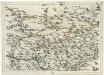
Geographica Provinciarum Sveviae Descriptio =
Mollova mapová sbírka Hurter, Johann Christoph Bodenehr, Gabriel
[Philipsbourg]
1 Blatt : 60 x 91 cm s.n.
Vorstellung der Linie u[nd] Inondation von Bruchsahl bis Ketsch
1 : 60000 Mollova mapová sbírka Riecke, Gustav Friedrich Homann, Johann Baptista - dědici
Eigentlicher Plan des Feldlagers der Kayserlichen- und Reichs-Armee unter dem Com[m]ando des Printzens Evgenii vom 1sten bis 22 Julii A.o 1734 bey der von der frantzösischen Armee hart belagerten Festung Philippsbvrg nebst dem accuraten Plan des frantzösischens Retrenchements

Plan der Kayserlichen und Reichs Vöstung Philippsburg
1 : 35000 Mollova mapová sbírka Duchaffat, Antoine
Grundris der Vestung Philippsburg nebst denen feindlichen Attaquen, Circumvalations-Linien u. Batterien aus welchen die Französische Armee den 23. May. 1734 die Vestung zu belagern, und den 7. Juny, selbige zu beschiessen angefangen und nach tapferer [...]
1 : 20000 auf das accurateste vorgestellet von einem berühmten Ingenieur L. S. C.
Plan der R. Vestung Philipsburg
Mollova mapová sbírka Homann, Johann Baptista - dědici
Eigentlicher Plan des Feldlagers der Kayserlichen- und Reichs-Armee unter dem Commando des Printzens Eugenii vom 1sten bis 22 Julii Ao. 1734 bey der von der Frantzösischen Armee hart belagerten Festung, Philippsburg
1 : 30000 Mollova mapová sbírka Evžen Savojský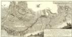
Carte von Linie und Innondation, von Bruchsal bis Kethsch, woselbst die Innondation in Rhein fließet.
1 : 65000 Mollova mapová sbírka Riecke, Gustav Friedrich Bodenehr, Gabriel
Le Flambeau de la Guerre Allumee au Rhin
Mollova mapová sbírka Delisle, Guillaume Schenk, Peter II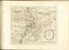

Der Pfinz und Enz Kreis im Grossherzogthum Baden
1 : 200000 Bádensko (Německo) Krauth Wolff, F. C.F. Müllerschen Buchhandlung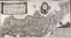
Accurate Special-Charte der Gegend des Rheins, von Ettlingen, Carls Ruhe, Philippsburg, Bruchsal, bis Mannheim, etc. Entworffen
Riecke, Gustav Friedrich; Ostertag, Heinrich Jonas; Cöntgen, Bartolomäus Anton Brönner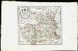
Des Herzogthums Würtemberg nordwestliche Aemter mit der freyen Reichsstadt Weil : Nro. 187
Reilly, Franz Johann Joseph von
Carte Particuliere de Pays qui sont situéz entre le Rhein, la Saare, la Moselle, et la Basse Alsace
1 : 150000 Mollova mapová sbírka Jaillot, Alexis-Hubert Jaillot, Alexis Hubert
Exact und Gantz accurater Plan
1 : 570000 Mollova mapová sbírka Geyer, Friedrich W. Berndt, Johann Christoph Geyer, Friedrich
Suevia Universa
1 : 170000 Mollova mapová sbírka Michal, Jacques de Seutter, Matthäus Seutter, Matthäus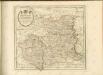

Carlsruhe - Stuttgart
1 : 200000 Herder, Benjamin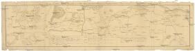
Camps et marches de l'armée imperiale com[m]andée par S.A.S. le prince de Savoye pour retourner de Wesenthal prés de Philippsbourg, et aller passer le Rhein a Mayence, l'armée de France étant campé a Oppenheim prés de céte ville
Mannheim (Německo) Müller, Johann Conrad
Territorium Seculare Episcopatvs Spirensis una cum terris adiacentibus
1 : 140000 Mollova mapová sbírka Blödtner, Cyriak Homann, Johann Baptista - dědici
Die untere Markgrafschaft Baaden oder die Grafschaft Eberstein mit den Durlachischen Landen
1 Karte : Kupferdruck ; 18 x 24 cm Reilly F. J. J. von Reilly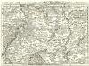
Staaten ahm Rhein, und Necker
1 : 180000 Mollova mapová sbírka Person, Nikolaus Person, Nicolas
Kriegs-Theatrum.
Mollova mapová sbírka Lidl, Johann Jakob Lidl, Johann Jacob

Suevia universa IX. tabulis delineata, 1
1 Blatt : s.n.
![Meßtischblatt 46 [6817]: Bruchsal, 1876](https://images-2.georeferencer.com/images/iiif/186089179787/full/,300/0/native.jpg)

