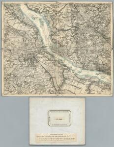
Maps of Geest und Marsch Südholstein

145. Stade. (Germany)
1 : 100000 Reichsamt fur Landesaufnahme
Nordsee
1 : 25000 Labe (Česko a Německo : řeka : dolní tok) Reichs-Marine-Amt
Nordsee
1 : 25000 Labe (Česko a Německo : řeka : dolní tok) Reichs-Marine-Amt
Meßtischblatt Ütersen
1 : 250000 Ütersen. - Aufn. 1878, hrsg. 1880, einz. Nachtr. 1896. - 1:25000. - [Berlin]: Reichsamt für Landesaufnahme, 1896. - 1 Kt.
Meßtischblatt 1027 : Horneburg, 1906
1 : 250000 Horneburg. - Aufn. 1878, hrsg. 1880,einz. Nachtr. 1906. - 1:25000. - [Berlin]: Reichsamt für Landesaufnahme, 1906. - 1 Kt.
Meßtischblatt 930 : Stade, 1880
1 : 250000 Stade. - Aufn. 1878. - 1:25000. - [Berlin]: Reichsamt für Landesaufnahme, 1880. - 1 Kt.
Meßtischblatt Pinneberg
1 : 250000 Pinneberg. - Aufn. 1878, bericht. 1927. - 1:25000. - [Berlin]: Reichsamt für Landesaufnahme, 1927. - 1 Kt.
Meßtischblatt 1026 : Hagen, 1898
1 : 250000 Hagen. - Aufn. 1878, einz. Nachtr. 1898. - 1:25000. - [Berlin]: Reichsamt für Landesaufnahme, 1898. - 1 Kt.
Meßtischblatt 1028 : Wedel, 1933
1 : 250000 Wedel. - Hrsg. 1880, bericht. 1927. - 1:25000. - [Berlin]: Reichsamt für Landesaufnahme, 1933. - 1 Kt.
Composite: 145. Stade. (Germany)
1 : 100000 Reichsamt fur Landesaufnahme
Meßtischblatt 834, neue Nr. 2223 : Elmshorn, 1880
1 : 250000 Elmshorn. - Aufn. 1878, hrsg. 1880. - 1:25000. - [Berlin]: Reichsamt für Landesaufnahme, 1880. - 1 Kt.
Meßtischblatt 835 : Barmstedt, 1906
1 : 250000 Barmstedt. - Aufn. 1878, hrsg. 1880, einz. Nachtr. 1899. - 1:25000. - [Berlin]: Reichsamt für Landesaufnahme, 1906. - 1 Kt.
COMITATVS | PINNEN BERG
Andres Lorensen | Rodtgießer Husum | sculps. [Amsterdam : Joan Blaeu]
40. Hamburg, uit: Topographische Uebersichtskarte des Deutschen Reiches / herausgegeben v. d. Kartogr. Abt. d. Königl. Preuß. Landesaufnahme
1 : 200000 titelvariant: Topogr. Übersichtskarte des Deutschen Reiches; Annotatie: Titel boven bladen ook: Topogr. Übersichtskarte des Deutschen Reiches; Annotatie geografische gegevens: Op elk blad twee maatstokken: 10 Kilometer = 5,5 cm; 1 geogr. Meile = 3,6 cm; Legenda onder op elk blad Königlich Preußische Landesaufnahme. Kartographische Abtheilung [S.l : Königlich Preußische Landesaufnahme, Kartographische Abtheilung]
Nobilissimi Albis Fluvii Ostia, nec non Hamburgense et alia Territoria adjacentia
1 : 170000 Mollova mapová sbírka Visscher, Nicolaes Schenk, Peter II
Hamburg mit dero Gegend Westwerts, die Elbe hinunter zu fahren Bis Gluckstadt.
1 : 320000 Mollova mapová sbírka Bodenehr, Gabriel Bodenehr, Gabriel


Celeberrimi Flvvii Albis nova delineatio Auctore Christiano Mollero
1 : 160000 Mollova mapová sbírka Moller, Christian Blaeu, Willem Jansz.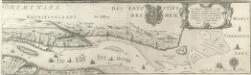
Celeberrimi Flvvii Albis nova delineatio Auctore Christiano Mollero
1 : 160000 Mollova mapová sbírka Moller, Christian Blaeu, Willem Jansz.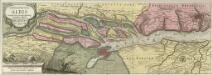
Nobilis Fluvius Albis maximâ curâ ex variis famosisq; Autoribus collectus et in lucem editus
1 : 250000 Mollova mapová sbírka Schenk, Pieter Schenk, Peter I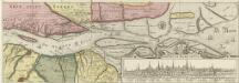
Nobilis Fluvius Albis maximâ curâ ex variis famosisq; Autoribus collectus et in lucem editus
1 : 250000 Mollova mapová sbírka Schenk, Pieter Schenk, Peter I
Nobilis fluvius Albis
1 : 160000 Hamburk (Německo) Visscher, Claes Jansz. Nicolao Johannide Piscatore
Tabula geographica novissima ducatus Stormariae in meridionali parte Holsatiae
1 : 209000 Holštýnsko Schenk, Pieter Valk, Gerhard apud P. Schenk et G. Valk
Tabula Geographica novissima Ducatus Stormariae in Meridionali parte Holsatiae
1 : 210000 Mollova mapová sbírka Schenk, Pieter Schenk, Peter I
STORMARIA | DVCATVS
Auctore Joh: Meyer Husumensi. Matthias & Nicolaus Peters | Goldtschmide gebr. Hus. sculp. [Amsterdam : Joan Blaeu]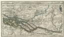
Hamburg mit dero Gegend Oostwerts bis Lauenburg Sampt denen in Gemeinschaft Lubeck besitzenden Vier Laendern.
1 : 320000 Mollova mapová sbírka Bodenehr, Gabriel Bodenehr, Gabriel
Dvcatvs Bremae et Princ. Verdae
1 : 200000 Mollova mapová sbírka
Hamburg 33, uit: Special-Karte von Mittel-Europa / nach amtlichen Quellen bearbeitet von W. Liebenow
1 : 300000 titelvariant: W. Liebenow's Mittel-Europa; Annotatie: Titel boven de bladen: W. Liebenow's Mittel-Europa Johannes Wilhelm Liebenow 1822-1897 Frankfurt a. M. : Ludwig Ravenstein