Maps of Hamburg-Mitte

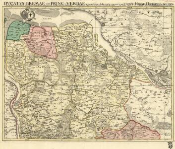
Dvcatvs Bremae et Princ. Verdae
1 : 200000 Mollova mapová sbírka
Paskaart vande Iade, Weser en Elve :
1 : 250000 Mollova mapová sbírka Keulen, Johannes van Keulen, Johannes van

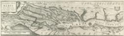
Celeberrimi Flvvii Albis nova delineatio Auctore Christiano Mollero
1 : 160000 Mollova mapová sbírka Moller, Christian Blaeu, Willem Jansz.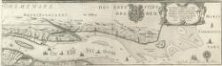
Celeberrimi Flvvii Albis nova delineatio Auctore Christiano Mollero
1 : 160000 Mollova mapová sbírka Moller, Christian Blaeu, Willem Jansz.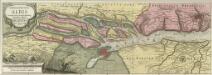
Nobilis Fluvius Albis maximâ curâ ex variis famosisq; Autoribus collectus et in lucem editus
1 : 250000 Mollova mapová sbírka Schenk, Pieter Schenk, Peter I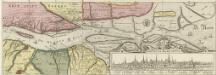
Nobilis Fluvius Albis maximâ curâ ex variis famosisq; Autoribus collectus et in lucem editus
1 : 250000 Mollova mapová sbírka Schenk, Pieter Schenk, Peter I
Nobilis fluvius Albis
1 : 160000 Hamburk (Německo) Visscher, Claes Jansz. Nicolao Johannide Piscatore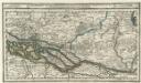
Hamburg mit dero Gegend Oostwerts bis Lauenburg Sampt denen in Gemeinschaft Lubeck besitzenden Vier Laendern.
1 : 320000 Mollova mapová sbírka Bodenehr, Gabriel Bodenehr, Gabriel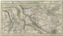
Hamburg mit dero Gegend Westwerts, die Elbe hinunter zu fahren Bis Gluckstadt.
1 : 320000 Mollova mapová sbírka Bodenehr, Gabriel Bodenehr, Gabriel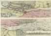
Nobilissimi Albis Fluvii Ostia, nec non Hamburgense et alia Territoria adjacentia
1 : 170000 Mollova mapová sbírka Visscher, Nicolaes Schenk, Peter II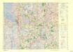
Central Europe 1:1,000,000, Bremerhaven
Sheet L3 of the 287 sheet series: Central Europe. 1 : 100,000. G.S.G.S. No. 4416. AMS. M641, M651, M671. [London?] ; Washington, D.C. : War Office : Army Map Service, U.S. Army.
COMITATVS | PINNEN BERG
Andres Lorensen | Rodtgießer Husum | sculps. [Amsterdam : Joan Blaeu]
39. Bremerhaven, uit: Topographische Uebersichtskarte des Deutschen Reiches / herausgegeben v. d. Kartogr. Abt. d. Königl. Preuß. Landesaufnahme
1 : 200000 titelvariant: Topogr. Übersichtskarte des Deutschen Reiches; Annotatie: Titel boven bladen ook: Topogr. Übersichtskarte des Deutschen Reiches; Annotatie geografische gegevens: Op elk blad twee maatstokken: 10 Kilometer = 5,5 cm; 1 geogr. Meile = 3,6 cm; Legenda onder op elk blad Königlich Preußische Landesaufnahme. Kartographische Abtheilung [S.l : Königlich Preußische Landesaufnahme, Kartographische Abtheilung]
40. Hamburg, uit: Topographische Uebersichtskarte des Deutschen Reiches / herausgegeben v. d. Kartogr. Abt. d. Königl. Preuß. Landesaufnahme
1 : 200000 titelvariant: Topogr. Übersichtskarte des Deutschen Reiches; Annotatie: Titel boven bladen ook: Topogr. Übersichtskarte des Deutschen Reiches; Annotatie geografische gegevens: Op elk blad twee maatstokken: 10 Kilometer = 5,5 cm; 1 geogr. Meile = 3,6 cm; Legenda onder op elk blad Königlich Preußische Landesaufnahme. Kartographische Abtheilung [S.l : Königlich Preußische Landesaufnahme, Kartographische Abtheilung]
Tabula Geographica novissima Ducatus Stormariae in Meridionali parte Holsatiae
1 : 210000 Mollova mapová sbírka Schenk, Pieter Schenk, Peter I
Nobilis Fluvius Albis maximâ curâ, ex variis, famosisque Autoribus collectus, et in lucem editus. [Karte, Teil 1], in: Gerardi Mercatoris et I. Hondii Newer Atlas, oder, Grosses Weltbuch, Bd. 1, S. 277.
1 Karte aus Atlas Mercator, Gerhard und Hondius, Jodocus Jansson, Jan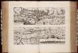
Nobilis fluvius Albis : maximâ curâ, ex varijs, famosisq. ... / a Nicolao Johannide Piscatore
1 : 152900 Annotatie: Origineel is Blad 81 in atlas factice; Annotatie geografische gegevens: Schaalstok: 2 Miliaria Germanica communia quorum 15 gradum unum latitudinis constituunt = 9 cm; Zuid boven; Inzet: Emporium Hamburgum Claes Jansz. Visscher 1586/1587-1652 [S.l. : s.n.]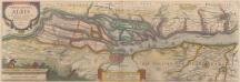
Nobilis Fluvius Albis maximâ curâ, ex variis famosisque Autoribus collectus, et in lucem editus. [Karte, Teil 1], in: Novus atlas absolutissimus, Bd. 2, S. 33.
1 Karte aus Atlas Janssonius Offizin
Composite: 145. Stade. (Germany)
1 : 100000 Reichsamt fur Landesaufnahme
Composite: 176. Bremervorde. (Germany)
1 : 100000 Reichsamt fur Landesaufnahme
176. Bremervorde. (Germany)
1 : 100000 Reichsamt fur Landesaufnahme
177. Buxtehude. (Germany)
1 : 100000 Reichsamt fur Landesaufnahme
Composite: 177. Buxtehude. (Germany)
1 : 100000 Reichsamt fur Landesaufnahme
144. Osten. (Germany)
1 : 100000 Reichsamt fur Landesaufnahme
145. Stade. (Germany)
1 : 100000 Reichsamt fur Landesaufnahme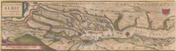
Celeberrimi Fluvii Albis nova delineatio [Karte, Teil 1], in: Novus Atlas, das ist, Weltbeschreibung, Bd. 1, S. 117.
1 Karte aus Atlas Blaeu, Joan Blaeu, Willem Janszoon
Celeberrimi Fluvii Albis nova delineatio [Karte, Teil 1], in: Le théâtre du monde, ou, Nouvel atlas contenant les chartes et descriptions de tous les païs de la terre, Bd. 1, S. 148.
1 Karte aus Atlas Blaeu, Willem Janszoon und Blaeu, Joan Blaeu, Willem Janszoon