Maps of Steinburg

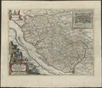
COMITATVS | PINNEN BERG
Andres Lorensen | Rodtgießer Husum | sculps. [Amsterdam : Joan Blaeu]
40. Hamburg, uit: Topographische Uebersichtskarte des Deutschen Reiches / herausgegeben v. d. Kartogr. Abt. d. Königl. Preuß. Landesaufnahme
1 : 200000 titelvariant: Topogr. Übersichtskarte des Deutschen Reiches; Annotatie: Titel boven bladen ook: Topogr. Übersichtskarte des Deutschen Reiches; Annotatie geografische gegevens: Op elk blad twee maatstokken: 10 Kilometer = 5,5 cm; 1 geogr. Meile = 3,6 cm; Legenda onder op elk blad Königlich Preußische Landesaufnahme. Kartographische Abtheilung [S.l : Königlich Preußische Landesaufnahme, Kartographische Abtheilung]
Nobilissimi Albis Fluvii Ostia, nec non Hamburgense et alia Territoria adjacentia
1 : 170000 Mollova mapová sbírka Visscher, Nicolaes Schenk, Peter II
Composite: 145. Stade. (Germany)
1 : 100000 Reichsamt fur Landesaufnahme
Composite: 112. Itzehoe. (Germany)
1 : 100000 Reichsamt fur Landesaufnahme
PRÆFECTVRA | STEINBORGH | cum | Kremper, et | Wilstermarsch.
Matthias & Nicolaus Peters | Goldtschmide gebr. Hus. sculps. [Amsterdam : Joan Blaeu]
Prospect und Grundris der Keiserl. Freyen Reichs und Ansee Stadt Hamburg, samt ihrer Gegend
1 : 40000 Mollova mapová sbírka Homann, Johann Baptist Homann, Johann Baptista
112. Itzehoe. (Germany)
1 : 100000 Reichsamt fur Landesaufnahme
145. Stade. (Germany)
1 : 100000 Reichsamt fur Landesaufnahme
Composite: 146. Hamburg. (Germany)
1 : 100000 Reichsamt fur Landesaufnahme
Plan von Hamburg
Hamburk (Německo) Georg Vigand's Verlag
Plan von Hamburg mit seinen Vorstädten
1 : 12600 Hamburk (Německo) Grieben, Th. Th. Grieben
Nordsee
1 : 25000 Labe (Česko a Německo : řeka : dolní tok) Reichs-Marine-Amt
Entwurf des generalplanes für die stadtweiterung. Blatt 1
1 : 20000 Meyer, Andreas, fl. 1896 Photolithographie v. Strumper & Co.
Composite: 113. Segeberg. (Germany)
1 : 100000 Reichsamt fur Landesaufnahme
Karte von der Gegend um Hamburg
1 : 140000
113. Segeberg. (Germany)
1 : 100000 Reichsamt fur Landesaufnahme
Karte von Hamburg nebst Umgebung für Touristen
1 : 100000 Hamburg : Verlag der Lith. Institut von Ch. Fuchs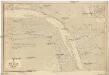
Nordsee
1 : 25000 Glückstadt (Německo) Reichs-Marine-Amt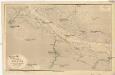
Nordsee
1 : 25000 Labe (Česko a Německo : řeka : dolní tok) Reichs-Marine-Amt
Prospect und Grundris der keiserl. freyen Reichs und Ansee Stadt Hamburg, samt ihrer Gegend
1 : 40000 Hamburk (Německo) Homann, Johann Baptist Ioh. Bapt. Homann
Prospect und Grundris der keiserl. freyen Reichs und Ansee Stadt Hamburg, samt ihrer Gegend
1 : 40700 Hamburk (Německo) Homann, Johann Baptist Ioh. Bapt. Homann
Plan zur Veranschaulichung der Wasserversorgung Hamburg's, mit der Situation der projectirten Filtrations Anlage
1 : 20000 Strumper & Co.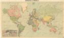
Bez titulu: Politische Weltkarte

H. Carly's Bebauungs-Plan von Hamburg und sämtlichen Hamburgischen Vororten : nebst Plan von Altona-Ottensen, Wandsbeck und Umgebung sowie Plan von Hagenbecks Tierpark
Carly, H Druck und Verlag H. Carly (Inh. Oscar und Robert Enoch)
Grosser Plan von Hamburg, Altona-Ottensen und Wandsbek
1 : 14000 Verl.-Anst. (vormals J. Richter)
Meßtischblatt 1030 : Wandsbek, 1927
1 : 250000 Wandsbek. - Aufn. 1878, bericht. 1927. - 1:25000. - [Berlin]: Reichsamt für Landesaufnahme, 1927. - 1 Kt.
Meßtischblatt 1030 : Wandsbek, 1917
1 : 250000 Wandsbek. - Aufn. 1878, hrsg. 1881, Auflagedr. 1917. - 1:25000. - [Berlin]: Reichsamt für Landesaufnahme, 1917. - 1 Kt.
Meßtischblatt 1029 : Hamburg, 1933
1 : 250000 Hamburg. - Aufn. 1878, hrsg. 1881, bericht. 1927. - 1:25000. - [Berlin]: Reichsamt für Landesaufnahme, 1933. - 1 Kt.