Maps of Bolívar

Orinoco.
1 : 2650000 Restrepo, Jose Manuel, 1781-1863
Partie, Colombie. Amer. Merid. 3.
1 : 1641836 Vandermaelen, Philippe, 1795-1869
Facsimile: Guiana by Blaeuw.
1 : 7100000 Blaeuw, William
Boundaries Claimed or Proposed.
1 : 2027520 Venezuela-British Guiana Boundary Commission
The coast of Caracas, Cumana, Parla and the mouths of Rio Orinoco.
1 : 1560000 Jefferys, Thomas
Forests and Savannas.
1 : 2027520 Venezuela-British Guiana Boundary Commission
European Occupation in 1803 (1814).
1 : 2027520 Venezuela-British Guiana Boundary Commission
Drainage Basins.
1 : 2027520 Venezuela-British Guiana Boundary Commission
European Occupation in 1648.
1 : 2027520 Venezuela-British Guiana Boundary Commission
European Occupation in 1796.
1 : 2027520 Venezuela-British Guiana Boundary Commission
European Occupation in 1773.
1 : 2027520 Venezuela-British Guiana Boundary Commission
European Occupation in 1703.
1 : 2027520 Venezuela-British Guiana Boundary Commission
European Occupation in 1674.
1 : 2027520 Venezuela-British Guiana Boundary Commission
European Occupation in 1597.
1 : 2027520 Venezuela-British Guiana Boundary Commission
European Occupation in 1626.
1 : 2027520 Venezuela-British Guiana Boundary Commission
European Occupation in 1724.
1 : 2027520 Venezuela-British Guiana Boundary Commission
European Occupation in 1756.
1 : 2027520 Venezuela-British Guiana Boundary Commission
Grand View of European Occupation, 1597-1803 (1814).
1 : 2027520 Venezuela-British Guiana Boundary Commission
(Provincias de Margarita, Cumana, Barcelona, Guayana)
1 : 1300000 Codazzi, Agustin, 1793-1859
Facsimile: Surinam by Popple.
1 : 3787000 Popple, Henry
Facsimile: Part of Chart of the Guiana Coast by Jefferys.
1 : 1510000 Jefferys, Thomas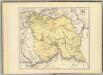
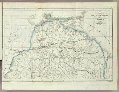
Carta del Canton de Upata, Provincia de Guayana.
1 : 1300000 Codazzi, Agustin, 1793-1859
(La provincia de Caracas dividida por cantones)
1 : 1340000 Codazzi, Agustin, 1793-1859
Facsimile: Part of the Great Colonial Map by Schomburgk.
1 : 1430000 Brown, Charles B.
A new chart of the coast of Guyana from Rio Orinoco to River Berbice.
1 : 550000 Jefferys, Thomas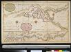
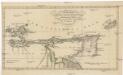
De rivier van Oronoque van Moco Moco tot St. Thome en een gedeelte van de Golf van Paria
Venezuela Gerard van Keulen
Facsimile: Part of South America by Arrowsmith.
1 : 2800000 Arrowsmith, John
Facsimile: Part of Northern Coast of South America by Jefferys.
1 : 1540000 Jefferys, Thomas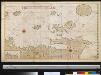
Een gedeelte van de kust van Venezuela en van de Caribesse Eijlanden van t eijland Granada tot t eijland Roca door d Engelse afgeteek(end)
Venezuela Gerard van Keulen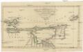
Charte von den Inseln TRINIDAD, TABAGO und MARGARETHA, dem Busen von PARIA, und einem Theile von CUMANA
1 : 1900000 Trinidad a Tobago