Maps of Faroe Islands

Scotland.
1 : 1530000 Greenleaf, Jeremiah
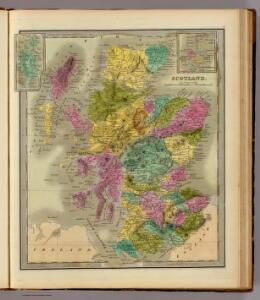
Scotland.
1 : 1457280 Greenleaf, Jeremiah
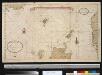
FAEROARUM Prima & accurato DELINEATIO
1 : 294000 Faerské ostrovy Debes, L. J. Rothsteen, Jano
Faeroerne 1:200 000
1 : 200000 Faerské ostrovy Geodaetisk institut
England IV.
1 : 765000 Society for the Diffusion of Useful Knowledge (Great Britain)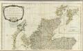
A new and correct map of Scotland or North Britain (Northern section)
1 : 447000 Campbell, Robert, Lieutenant
Les isles Orcadney, ou Orkney; Schetland, ou Hetland; et de Fero, ou Farre
1 Karte : Kupferdruck ; 41 x 52 cm Sanson; Fortin chez le Sr. Fortin ing.r pour les globes rue de la Harpe près celle du Foin
Les isles Orcadney, ou Orkney; Schetland, ou Hetland; et de Fero, ou Farre
1 Karte : Kupferdruck ; 41 x 52 cm Sanson; Mariette chez Pierre Mariette rue St. Iacques a l'Esperance
Feuille 15 (A III), uit: Carte géologique internationale de l'Europe : la carte, votée au congrès géologique international de Bologne en 1881, est exécutée conformément aux décisions d'une commission internationale, avec le concours des gouvernements, sous le dir. de M.M. Beyrich et Hauchecorne
Annotatie: Blad 48 gamme des couleurs; blad 49: bladwijzer en titelblad Heinrich Ernst Beyrich 1815-1896; Wi. Hauchecorne Berlin : Reimer / (Berlin: Institut lithographique)
Paskaart vande noord cust van Schotland als mede de eylanden van Hitlandt en Fero. Naaukeuring opgestelt en van veel fouten verbetert ... / Iohannes van Keulen.
Keulen, Johannes van, 1654-1715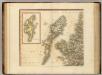
Scotland NW.
1 : 500000 Cary, John, ca. 1754-1835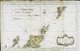
Partie septentrionale de l'Ecosse
1 Karte : Kupferdruck ; 50 x 82 cm s.n.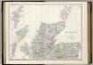
Scotland N.
1 : 633600 Johnston, Alexander Keith, 1804-1871
Insulae Iohannis Mayen Cum universo situ Sinuum et Promontoriorum. [...] [Karte], in: Het vijfde Deel Des Grooten Atlas : Vervatende De Water-Weereld, S. 131.
1 Karte aus Atlas Jansson, Jan Jansson, Jan
INSVLA | QVÆ À | IOANNE MAYEN | NOMEN SORTITA EST.
[Amsterdam : Joan Blaeu]
Russian Empire.
1 : 21000000 Greenleaf, Jeremiah
Russian Empire.
1 : 21000000 Greenleaf, Jeremiah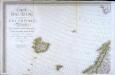
Carte d'Europe ou sont tracées les limites des empires, royaumes, et etats souverains, feuille 1
1 Blatt : 63 x 96 cm Semen etc
Museumskart 178: Sjøkart over Norskehavet
1 : 1000000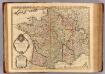
France.
1 : 2100000 L'Isle, Guillaume de, 1675-1726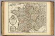
Carte de France.
1 : 2100000 L'Isle, Guillaume de, 1675-1726
Golfe de Botnie.
1 : 3700000 Vincent
[II], uit: Geognostische Karte des Oesterreichischen Kaiserstaates mit einem grossen Theile Deutschland's u. Italien / hauptsachlich nach ... Haidinger's geognostischer Karte dieses Staates bearb. von Josef Scheda
1 : 3000000 titelvariant: General-Karte von Europa in 25 Blättern; Annotatie: Bijlage bij: General-Karte von Europa in 25 Blättern. - 1:2.592.000. - 1845-1847 Scheda, Joseph Wien : K.K. Militär. Geografisch. Institut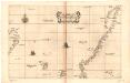
Museumskart 17 Kart over Norskehavet med Island, Færøyene, Shetland og norskekysten
1 : 500000 Robert Dudley
Feuille 9 (B II), uit: Carte géologique internationale de l'Europe : la carte, votée au congrès géologique international de Bologne en 1881, est exécutée conformément aux décisions d'une commission internationale, avec le concours des gouvernements, sous le dir. de M.M. Beyrich et Hauchecorne
Annotatie: Blad 48 gamme des couleurs; blad 49: bladwijzer en titelblad Heinrich Ernst Beyrich 1815-1896; Wi. Hauchecorne Berlin : Reimer / (Berlin: Institut lithographique)
Feuille 3 (C I), uit: Carte géologique internationale de l'Europe : la carte, votée au congrès géologique international de Bologne en 1881, est exécutée conformément aux décisions d'une commission internationale, avec le concours des gouvernements, sous le dir. de M.M. Beyrich et Hauchecorne
Annotatie: Blad 48 gamme des couleurs; blad 49: bladwijzer en titelblad Heinrich Ernst Beyrich 1815-1896; Wi. Hauchecorne Berlin : Reimer / (Berlin: Institut lithographique)
Carte generale de toute l'Europe, 1
1 Blatt : 57 x 48 cm J.M. Will
Feuille 2 (B I), uit: Carte géologique internationale de l'Europe : la carte, votée au congrès géologique international de Bologne en 1881, est exécutée conformément aux décisions d'une commission internationale, avec le concours des gouvernements, sous le dir. de M.M. Beyrich et Hauchecorne
Annotatie: Blad 48 gamme des couleurs; blad 49: bladwijzer en titelblad Heinrich Ernst Beyrich 1815-1896; Wi. Hauchecorne Berlin : Reimer / (Berlin: Institut lithographique)
Partie, Norwege. Europe 3.
1 : 1641836 Vandermaelen, Philippe, 1795-1869