Maps of Iceland

Feuille 9 (B II), uit: Carte géologique internationale de l'Europe : la carte, votée au congrès géologique international de Bologne en 1881, est exécutée conformément aux décisions d'une commission internationale, avec le concours des gouvernements, sous le dir. de M.M. Beyrich et Hauchecorne
Annotatie: Blad 48 gamme des couleurs; blad 49: bladwijzer en titelblad Heinrich Ernst Beyrich 1815-1896; Wi. Hauchecorne Berlin : Reimer / (Berlin: Institut lithographique)
Museumskart 17 Kart over Norskehavet med Island, Færøyene, Shetland og norskekysten
1 : 500000 Robert Dudley
Het Noorder deel van de Noord Zee seer dienstig voor de Oostindise kruijsers
North Sea Gerard van Keulen
Charte von Island und den Färöer Inseln
1 : 1400000 Faerské ostrovy
CHARTE von ISLAND und den Färöer Inseln
1 : 1420000 Faerské ostrovy
Partie, Norwege. Europe 3.
1 : 1641836 Vandermaelen, Philippe, 1795-1869
Carte internationale du monde au 1:1,000,000 E
1 : 1000000 Generalstabens topografiske Afdeling
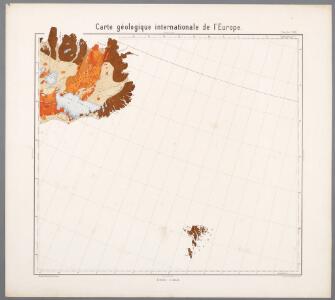
Feuille 15 (A III), uit: Carte géologique internationale de l'Europe : la carte, votée au congrès géologique international de Bologne en 1881, est exécutée conformément aux décisions d'une commission internationale, avec le concours des gouvernements, sous le dir. de M.M. Beyrich et Hauchecorne
Annotatie: Blad 48 gamme des couleurs; blad 49: bladwijzer en titelblad Heinrich Ernst Beyrich 1815-1896; Wi. Hauchecorne Berlin : Reimer / (Berlin: Institut lithographique)
Islande. Europe 1 bis.
1 : 1641836 Vandermaelen, Philippe, 1795-1869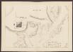
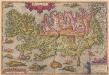
Islandia. [Karte], in: Atlas, sive, Cosmographicae meditationes de fabrica mundi et fabricati figura, S. 77.
1 Karte aus Atlas Mercator, Gerhard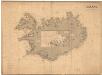
Museumskart 192: Iceland
J. W. Appleton Norie & Wilson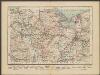
Islandia. [Karte], in: Gerardi Mercatoris Atlas, sive, Cosmographicae meditationes de fabrica mundi et fabricati figura, S. 79.
1 Karte aus Atlas Mercator, Gerhard Montanus, Petrus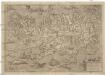
Islandia
1 : 2046000 Island Velleius, Andreas Frederik A. Ortel.
Island
1 : 1350000 Annotatie: Met administratieve indeling [S.l. : s.n.]
INSVLAE ISLANDIAE delineatio, prout haec Solenni mensurandi negotio sub Auspiciis Potentissimi Regis DANIAE facto, & a 1734 demum per Cnopfium Archit. militarem ad finem perducto, debetur
1 : 1600000 Island studio et impensis Homannianorum Heredum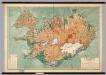
Iceland -- Physical-Political
1 : 500000 Danish General Staff
Danish Islands in the North Atlantic Ocean.
1 : 3000000 Fullarton, A. & Co.
Charte von Island und den Färöer Inseln
1 : 1400000 Faerské ostrovy Streit, Friedrich Wilhelm
Charte von Island und den Färöer Inseln
1 : 1400000 Faerské ostrovy Streit, Friedrich Wilhelm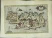
Islandia
1 Karte : Kupferdruck ; 26 x 42 cm Mercator; Hondius Henricus Hondius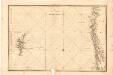
Museumskart 180: Den nordlige delen av Nordsjøen, med Shetland og deler av Norskekysten
1 : 500000 C. Akrel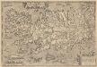
Islandia. [Karte], in: Theatrum orbis terrarum, S. 384.
1 Karte aus Atlas Ortelius, Abraham Vrients, Jan Baptista
51. Iceland, Denmark. The World Atlas.
1 : 2500000 USSR (Union of Soviet Socialist Republics).
Islandia. [Karte], in: Theatrum orbis terrarum, S. 290.
1 Karte aus Atlas Ortelius, Abraham
Tabula Islandiae [Karte], in: Le théâtre du monde, ou, Nouvel atlas contenant les chartes et descriptions de tous les païs de la terre, Bd. 1, S. 41.
1 Karte aus Atlas Blaeu, Willem Janszoon und Blaeu, Joan Blaeu, Willem Janszoon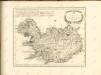

Sweden & Norway.
1 : 2217600 Arrowsmith, John
Tabula Islandiae [Karte], in: Gerardi Mercatoris et I. Hondii Newer Atlas, oder, Grosses Weltbuch, Bd. 1, S. 45.
1 Karte aus Atlas Mercator, Gerhard und Hondius, Jodocus Jansson, Jan