Maps of Peru

Peru.
1 : 6000000 Carey, Mathew
Peru.
1 : 9500000 Carey, Mathew
Mapa del Perú
1 : 4000000 Peru Pesce, Luis Carlos Fabbri
Mittel- und Nord-Peru und Ekuador
1 : 3000000 Ekvádor Pape, Eduard Tessmann, Günter Friederichsen, De Gruyter & Co.
Mapa del Peru
1 : 5000000 Raimondi, Antonio 1826-1890 Paris : Erhard Frères
Ttahuantin-Suyu, or, the empire of the Yncas (except Quito and Chile) : in its four great divisions of Chincha-Suyu, Cunti-Suyu, Anti-Suyu, Colla-Suyu : with their tribes and ayllus or lineages, also the routes of the Ynca conquerors
1 : 3000000 Markham, Clements R. (Clements Robert), Sir, 1830-1916
Peru
1 : 6530000 Peru Finlayson im Verlage des Geographischen Instituts
CHARTE der PROVINZ oder AUDIENCIA von LIMA oder des alten Königreichs PERU
1 : 5500000 Peru
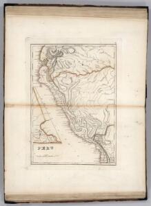
Peru.
1 : 11088000 Lucas, Fielding Jr.
Charte der Provinz oder Audiencia von Lima oder des alten Königreichs Peru

Geographisch-statistische und historische Charte von Peru
1 : 3500000 gezeichnet von Finlayson Weimar : Verlag des Geographischen Instituts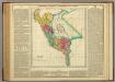
Map Of Peru.
1 : 6336000 Lea, I.
Mapa general del Peru.
1 : 3250000 Paz Soldan, Mariano Felipe, 1821-1886
Mapa mineralogico del Peru.
1 : 3300000 Paz Soldan, Mariano Felipe, 1821-1886
Fondeaderos de algunos puertos del Peru.
Paz Soldan, Mariano Felipe, 1821-1886
Mapa de los ferrocarriles del Peru : de sus principales vias de comunicación terrestres, fluviales y maritimas, y de la futura red ferroviaria según los proyectos formulados con indicación de los vias interfluviales llamadas varaderos
1 : 3000000 Vallejos Z., Camilo Lit. tip. Badiola y Berrio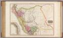
Peru.
1 : 3125000 Pinkerton, John, 1758-1826
Cote, Perou.
1 : 2200000 Spain. Marina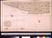
Een gedeelte van de Zuijdt Zee aen de kust van Peru van Guarmaij tot Quila int groot
Peru Gerard van Keulen
Asuay.
1 : 2700000 Restrepo, Jose Manuel, 1781-1863
Partie, Colombie. Amer. Merid. 8.
1 : 1641836 Vandermaelen, Philippe, 1795-1869
Partie du Perou. Amer. Merid. 14.
1 : 1641836 Vandermaelen, Philippe, 1795-1869
Partie du Perou. Amer. Merid. 20.
1 : 1641836 Vandermaelen, Philippe, 1795-1869
(East) Provincia litoral de Loreto.
1 : 1080000 Paz Soldan, Mariano Felipe, 1821-1886
Composite: Provincia litoral de Loreto.
1 : 1080000 Paz Soldan, Mariano Felipe, 1821-1886
(West) Provincia litoral de Loreto.
1 : 1080000 Paz Soldan, Mariano Felipe, 1821-1886
Departamento de Cuzco.
1 : 1090000 Paz Soldan, Mariano Felipe, 1821-1886
Mapa del sur del Peru y parte de Bolivia
1 : 1000000 Arequipa : J.L. Villanueva
Lecho, Rio Amazonas; Corte vertical, camino de Lima-Cerro de Pasco.
Paz Soldan, Mariano Felipe, 1821-1886