Maps of Loreto

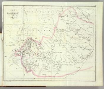
Asuay.
1 : 2700000 Restrepo, Jose Manuel, 1781-1863
Partie, Colombie. Amer. Merid. 8.
1 : 1641836 Vandermaelen, Philippe, 1795-1869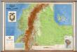
Ecuador -- Physical
1 : 500000 Instituto Geografico Militar
Ecuador.
1 : 2700000 Restrepo, Jose Manuel, 1781-1863
Carta geográfica del Ecuador
1 : 445000 Wolf, Teodoro Instituto geográfica de H. Wagner & E. Debes
(East) Provincia litoral de Loreto.
1 : 1080000 Paz Soldan, Mariano Felipe, 1821-1886
Composite: Provincia litoral de Loreto.
1 : 1080000 Paz Soldan, Mariano Felipe, 1821-1886
(West) Provincia litoral de Loreto.
1 : 1080000 Paz Soldan, Mariano Felipe, 1821-1886
Carta Geografica del Ecuador.
1 : 445000 Wolf, Teodoro
Carte de la province de Quito au Perou / dressée sur les observations astronomiques, journaux de route et mémoires de Mr. de la Condamine et sur ceux de Don Pedro Maldonado par Mr. D'Anville
1 Mapa, b/n. Tom. XIII, no 10. - Les triangles tracés dans cette carte sont ceux qui ont servi a la mesure de la Meridienne Anville, Jean Baptiste Bourguignon d'
Guayaquil.
1 : 2700000 Restrepo, Jose Manuel, 1781-1863
Mapa del Peru
1 : 500000 Raimondi, Antonio 1826-1890 Paris : Erhard Frères
Mapa del Peru
1 : 500000 Raimondi, Antonio 1826-1890 Paris : Erhard Frères
Mapa del Peru
1 : 500000 Raimondi, Antonio 1826-1890 Paris : Erhard Frères
Mapa del Peru
1 : 500000 Raimondi, Antonio 1826-1890 Paris : Erhard Frères
Plano de caminos, Departamento de Amazonas.
1 : 735000 Paz Soldan, Mariano Felipe, 1821-1886
Departamento de Amazonas.
1 : 1070000 Paz Soldan, Mariano Felipe, 1821-1886
Lecho, Rio Amazonas; Corte vertical, camino de Lima-Cerro de Pasco.
Paz Soldan, Mariano Felipe, 1821-1886
Departamento litoral de Piura.
1 : 1070000 Paz Soldan, Mariano Felipe, 1821-1886
Plateau von Quito
1 : 200000 Berghaus, Heinrich Karl Wilhelm, 1797-1884 J. Perthes
Vermischtes zur Geologie
Erster Band, enthaltend in vier Abtheilungen die Erscheinungen der anorganischen Natur: 1. Meteorologie und Klimatographie. 2. Hydrologie und Hydrographie. 3. Geologie. 4. Tellurischer Magnetismus Humboldt, Alexander von Verlag von Justus Perthes
Vermischtes zur Geologie.
Berghaus, Heinrich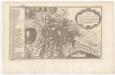
Plan de la ville et cite de St. Franciscois de Quito
1 mapa. A la part inferior: Tom. XIII, Num. 11.
Departamento de Cajamarca.
1 : 1080000 Paz Soldan, Mariano Felipe, 1821-1886
Mapa del Peru
1 : 500000 Raimondi, Antonio 1826-1890 Paris : Erhard Frères
Mapa del Peru
1 : 500000 Raimondi, Antonio 1826-1890 Paris : Erhard Frères
Mapa del Peru
1 : 500000 Raimondi, Antonio 1826-1890 Paris : Erhard Frères
Mapa del Peru
1 : 500000 Raimondi, Antonio 1826-1890 Paris : Erhard Frères
New Grenada.
1 : 3400000 Pinkerton, John, 1758-1826