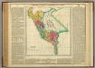
Maps of Cordillera Occidental

Cote, Perou.
1 : 2200000 Spain. Marina
Fondeaderos de algunos puertos del Peru.
Paz Soldan, Mariano Felipe, 1821-1886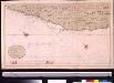
Een gedeelte van de Zuijdt Zee aen de kust van Peru van Guarmaij tot Quila int groot
Peru Gerard van Keulen
Partie du Perou. Amer. Merid. 20.
1 : 1641836 Vandermaelen, Philippe, 1795-1869
Departamento de Junin.
1 : 1090000 Paz Soldan, Mariano Felipe, 1821-1886
Corte geologico de la parte sud del Peru.
Paz Soldan, Mariano Felipe, 1821-1886
Departamento de Lima.
1 : 1080000 Paz Soldan, Mariano Felipe, 1821-1886
Departamento de Arequipa.
1 : 1100000 Paz Soldan, Mariano Felipe, 1821-1886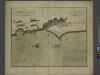
The city of LIMA where the vice Roy of Peru is Resident
from The sea-atlas : containing an hydrographical description of most of the sea-coasts of the known parts of the world.
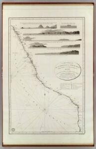
Cote, Perou.
1 : 830000 Lartigue, Joseph, 1791-1876
Departamento de Cuzco.
1 : 1090000 Paz Soldan, Mariano Felipe, 1821-1886
Partie du Perou. Amer. Merid. 14.
1 : 1641836 Vandermaelen, Philippe, 1795-1869
Mapa del sur del Peru y parte de Bolivia
1 : 1000000 Arequipa : J.L. Villanueva
Departamento de Moquegua.
1 : 1080000 Paz Soldan, Mariano Felipe, 1821-1886
Departamento de Ayacucho.
1 : 1080000 Paz Soldan, Mariano Felipe, 1821-1886
Departamento de Ancachs.
1 : 1080000 Paz Soldan, Mariano Felipe, 1821-1886
Provincia litoral de Ica.
1 : 1080000 Paz Soldan, Mariano Felipe, 1821-1886
Departamento de Huancavelica.
1 : 1090000 Paz Soldan, Mariano Felipe, 1821-1886
Mapa, exploracion de cuatro vias entre Lima, Juaja y Pasco.
1 : 830000 Paz Soldan, Mariano Felipe, 1821-1886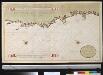
Port de Hillaij, reede van Hierbabouenna en Dierbaboine, de Hoek of Pointe Tambot en Rade deHillot aen de kust van Perou in de Zuijd Zee
Peru Grout Gerard van Keulen
Croquis, ferro-carril entre Arequipa y la costa.
1 : 317500 Paz Soldan, Mariano Felipe, 1821-1886
Callao de Lima, Valparaiso.
Ulloa, Antonio de, 1716-1795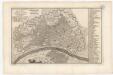
Plan scennographique de la cite des rois au Lima capitale du royaume de perou
1 mapa. A la part inferior: Tom. XIII, Num. 8.
Corte geologico de la parte sud del Peru.
Paz Soldan, Mariano Felipe, 1821-1886
Mapa del Peru
1 : 500000 Raimondi, Antonio 1826-1890 Paris : Erhard Frères
Mapa del Peru
1 : 500000 Raimondi, Antonio 1826-1890 Paris : Erhard Frères
Departamento de Puno.
1 : 1090000 Paz Soldan, Mariano Felipe, 1821-1886
Mapa del Peru
1 : 5000000 Raimondi, Antonio 1826-1890 Paris : Erhard Frères
Charte der Provinz oder Audiencia von Lima oder des alten Königreichs Peru