Maps of Carpathian Mountains
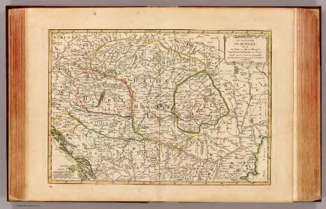
Hongrie, Transilvanie, Esclavonie, Croatie.
1 : 2650000 Janvier, Jean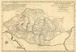
Mappa Potamologica In Qua Fluvii Ac Fluvioli Nominatiores Fere Omnes Qui in Monarchia Hungariae ad Danubium Sive Immediate Sive Mediate Confluunt; Lacus Item Ac Paludes Idea Generali Repraesentantur
1 : 2400000 Mollova mapová sbírka Marsili, Luigi Ferdinando
Ungarn und seine Nebenlande nach ihrer kirchlichen Eintheilung bis in das XVte. Jahrhundert.
1 : 3800000 Spruner von Merz, Karl
Regnorum Hungariae Dalmatiae, Croatiae, Sclavoniae Bosniae et Serviae cum principatu Transylvaniae, maximaque parte Valachiae nova et exacta tabula
1 : 784000 Bosna Homann, Johann Baptist Müller, Johann Christoph á Io. Bapt. Homanno
Donautiefland
Ungarn, Siebenbürgen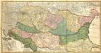
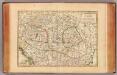
Novissima et Accuratissima totius Regni Hungariae, Dalmatiae, Croatiae, Sclavoniae, Bosniae, Serviae, Transylvaniae, cum Adiacentibus Regnis et Provinciis Tabula
1 : 2100000 Mollova mapová sbírka Sandrart, Jakob von Sandrart, Jacob von
General Charte vom Ungarn
1 : 890000 Bukovina (Rumunsko a Ukrajina) Güssefeld, Franz L. Rausch, J. Homannischen Erben
Pohraničí Rakousko-Uherska, Rumunska, Srbska a Bulharska
1 : 1250000 Bulharsko Machát, František V. Neubert
[Galizien, Ungarn Slavonien und Croatien, Siebenbürgen und Dalmatien, Moldau, Wallachey]
Hand-Atlas über alle Theile der Erde nach dem neuesten Zustande und über das Weltgebäude Stieler, Adolf bei Justus Perthes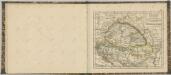

Ungarn und seine Nebenlande vom Regierungs-Antritte des Hauses Anjou bis zur Schlacht von Mohacs 1526.
1 : 3800000 Spruner von Merz, Karl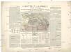
Carte ethnographique historique et stratégique des contrées Hongroises, Slaves, Moldo-Valaques et Allemandes de l'Empire Autrichien impliquées dans la guerre actuelle
Evropa jihovýchodní Bourgoing, Paul Charles Amable de imprimerie Gerdes
Die Laender an der untern Donau Vten.-Xte. Jahrhundert.
1 : 3800000 Spruner von Merz, Karl
Galizien, Ungarn mit Sclavonien und Croatien, Siebenbürgen und Dalmatien; Moldau, Walachey]
Stieler's Hand-Atlas Stieler, Adolf bei Justus Perthes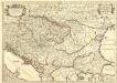
Le Royaume de Hongrie et les Estats qui en ont Esté sujets et qui font presentement la Partie Septentrionale de la Turquie en Europe.
1 : 2500000 Mollova mapová sbírka Sanson, Guillaume Cordier, Louis Jaillot, Alexis Hubert
Galizien, Ungarn, Slavonien, Kroatien, Siebenburgen, Dalmatien, Moldau, Wallachey.
1 : 10000000 Brudin, J. L.; Stieler, Adolf

Magyarország hegy- és vizrajzi térképe
1 : 2200000 Evropa jihovýchodní Homolka, Josef Eggenberger-féle könyvkereskedés
Ungarn und seine Nebenlande bis zum Aussterben Arpadischen Stammers 1301.
1 : 3800000 Spruner von Merz, Karl
Ungarn mit seinen Nebenländern und Galizien
1 : 1600000 Dalmácie jižní (Chorvatsko) Kiepert, Heinrich Eulenstein, F. Geographisches Institut
Ungarn mit seinen Nebenländern und Galizien
1 : 1600000 Dalmácie jižní (Chorvatsko) Kiepert, Heinrich Blaschnek Verlag des Geographischen Institut
Ungarn mit seinen Nebenländern und Galizien
1 : 1600000 Dalmácie jižní (Chorvatsko) Kiepert, Heinrich Blaschnek Verlag des Geographisches Institut
(La Hongrie)
1 : 10000000 Bruyset, Jean-Marie; Schneider, J. H.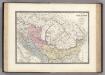
Dacie, Pannonie, Illyrie, Moesie Ancienne.
1 : 2886000 Levasseur, E.
Hvngariae ampliori significatu et veteris vel methodicae complexae regna: Hvngariae propriae, Croatiæ, Dalmatiae, Bosniae, Serviae, Bvlgariae, Cvmaniae, principatvm: Transylvaniae, despotatvs: Walachiae, Moldaviae [exclusis ab eadem alienatis Galitia et Lvdomiriria] in suas provincias ac partes divisae et quo ad imperanies ex Avstriacis, Tvrcis et Venetis distinctae [juncta tamen propter comoditatem Romania vel Romelia tvrcica] tabvla
1 Karte : Kupferdruck ; 45 x 57 cm Haas curantibus Homannianis Heredibus
Etats Orientaux De L'Empereur a partir De La Baviere Et De La Boheme : pour l'Ouvrage intitulé: De la Monarchie Prussienne
Mentelle, Edme
General Charte von Ungarn
1 : 2390000 Bukovina (Rumunsko a Ukrajina) Güssefeld, Franz L. Rausch, Johann Lorenz Jakob bey den Homannischen Erben
Karpatenländer, politische Übersicht
1 : 6000000 Donau-Karpaten-Gebiet