Maps of Carpathian Mountains

Ungarn und seine Nebenlande bis zum Aussterben Arpadischen Stammers 1301.
1 : 3800000 Spruner von Merz, Karl
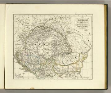
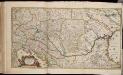
Karpatenländer, politische Übersicht
1 : 6000000 Donau-Karpaten-Gebiet

Galizien, Ungarn mit Sclavonien und Croatien, Siebenbürgen und Dalmatien; Moldau, Walachey]
Stieler's Hand-Atlas Stieler, Adolf bei Justus Perthes
Karpatenländer, Flusz- & Gebirgskarte
1 : 6000000 Donau-Karpaten-Gebiet
[Galizien, Ungarn Slavonien und Croatien, Siebenbürgen und Dalmatien, Moldau, Wallachey]
Hand-Atlas über alle Theile der Erde nach dem neuesten Zustande und über das Weltgebäude Stieler, Adolf bei Justus Perthes
Galizien, Ungarn mit Slavonien und Croatien, Siebenbürgen und Dalmatien, Moldau, Wallachey
1 : 3700000 Chorvatsko Justus Perthes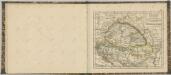

Ungarn und seine sudlichen Nachbarlander seit 1526.
1 : 3800000 Spruner von Merz, Karl
Die Laender an der untern Donau Vten.-Xte. Jahrhundert.
1 : 3800000 Spruner von Merz, Karl
Karpaten-Länder
Donau-Karpaten-Gebiet
Ungarn und seine Nebenlande nach ihrer kirchlichen Eintheilung bis in das XVte. Jahrhundert.
1 : 3800000 Spruner von Merz, Karl
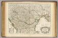
Le royaume de Hongrie
1 : 260000 Uhersko Delisle, Guillaume Covens et Mortier
Ungarn und seine Nebenlande vom Regierungs-Antritte des Hauses Anjou bis zur Schlacht von Mohacs 1526.
1 : 3800000 Spruner von Merz, Karl
Der Donauraum
1 : 1500000 Dunaj-oblast Justus Perthes
Galizien, Ungarn, Slavonien, Kroatien, Siebenburgen, Dalmatien, Moldau, Wallachey.
1 : 10000000 Brudin, J. L.; Stieler, Adolf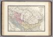
Dacie, Pannonie, Illyrie, Moesie Ancienne.
1 : 2886000 Levasseur, E.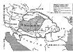
Ungarn nach dem Ersten Weltkrieg
Ungarn Weltkrieg <1914-1918>, Grenze
Le Royaume de Hongrie...
Totius Regni Hungariae maximaeque partis Danubii fluminis, una cum adjacentibus et finitimis regionibus novissima delineatio / per Nicolaum Visscher
1 : 2000000 Annotatie: Origineel is Blad 130 in atlas factice; Annotatie geografische gegevens: Met 2 schaalstokken Nicolaes Jansz. Visscher jr. 1649-1702 [Amsterdam : per Nicolaum Visscher]
Le Royaume de Hongrie et des pays qui en dependoient autrefois ; Nova et accurata Regni Hungariae tabula, ad usum serenissimi Burgundiae ducis
Ungarn, Osmanisches Reich L'Isle, Guillaume de
Nieuwe kaart van Hongarien en het noordelyke deel van Turkyen
1 : 5000000 [S.l.] : [s.n.]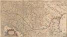
Totius Regni Hungariae, Maximaeque Partis Danubii Fluminis, una cum adjacentibus et finitimis Regionibus Novissima Delineatio [Karte], in: Novus atlas absolutissimus, Bd. 2, S. 293.
1 Karte aus Atlas Janssonius Offizin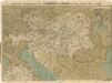
Prochaska ́s Neue Eisenbahnkarte von Österreich-Ungarn für 1898

Hvngaria Magna In Regna et Prouincias diuisa
1 : 7400000 Mollova mapová sbírka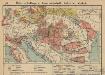
Österreich-Ungarn. Landwirtschaft und Fischerei
1 : 9000000 Österreich-Ungarn Landwirtschaft, Fischerei
90-91. Danube Countries. The World Atlas.
1 : 2500000 USSR (Union of Soviet Socialist Republics).
General Charte vom Ungarn
1 : 890000 Bukovina (Rumunsko a Ukrajina) Güssefeld, Franz L. Rausch, J. Homannischen Erben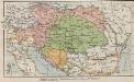
Österreich-Ungarn. Staaten
1 : 9000000 Österreich-Ungarn Verwaltungsgliederung