Maps of Magallanes y Antártica Chilena

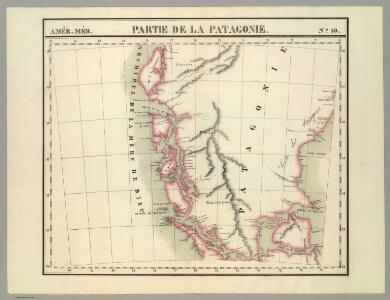
Partie, la Patagonie. Amer. Merid. 40.
1 : 1641836 Vandermaelen, Philippe, 1795-1869
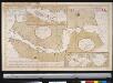
Exquisita & magno aliquot mensium periculo lustrata et iam retecta Freti Magellanici Facies. [...] [Karte], in: Gerardi Mercatoris Atlas, sive, Cosmographicae meditationes de fabrica mundi et fabricati figura, S. 562.
1 Karte aus Atlas Mercator, Gerhard Montanus, Petrus
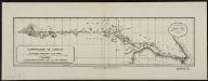
Chart Of The Straits Of Magellan.
1 : 880000 Jefferys, Thomas
Carte du Detroit de Magellan dressée sur les memoires de Mr. de la Morliere Doct.r de Sorbonne dediée à Monseigneur l'évêque de Viviers
Chile Gerard van Keulen
(Mapa de la Republica de Chile 11)
1 : 11000000 Pissis, Aime, 1812-1889
Mapa de la region patagonica entre los grados 47 y 52 sur
1 : 500000 Argentine. Oficina de Límites Internacionales [Buenos Aires ?] :
Demarcacion de limites entre la Republica argentina y la de Chile. Region meridional de la Patagonia
1 : 500000 Argentine. Oficina de Límites Internacionales [Buenos Aires ?] :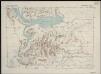
Magallanes [50°-51° S]
1 : 250000 Comisión Chilena de Límites [Santiago du Chili] : Comision chilena de limites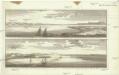
Vue de la riviere S. Julien ; Vue du port S. Julien
Schley, Jacobus van der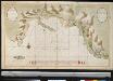
Port Galland of Haven van Gallan geleegen int midde van de Straet van Magelanus aen de Noordwal
Chile Grout Gerard van Keulen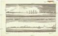
Vue du detroit de la maire entre la Terre de Feu et celle des etats
Ohňová země (Argentina a Chile) Schley, Jacobus van der
Composite: (Mapa de la Republica de Chile 9-15)
1 : 11000000 Pissis, Aime, 1812-1889
S. extremity of America.
1 : 4500000 Cook, James, 1728-1779
Tabula Magellanica, quâ Tierrae del fuego [...] [Karte], in: Theatrum orbis terrarum, sive, Atlas novus, Bd. 2, S. 359.
1 Karte aus Atlas Blaeu, Joan Blaeu, Willem Janszoon
Tabula Magellanica, quâ Tierrae del Fuego [...] [Karte], in: Le théâtre du monde, ou, Nouvel atlas contenant les chartes et descriptions de tous les païs de la terre, Bd. 2, S. 344.
1 Karte aus Atlas Blaeu, Willem Janszoon und Blaeu, Joan Blaeu, Willem Janszoon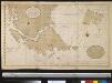
Verbeeterde caert van de uijthoek van Zuijd America waer in vervat sijn de onlangs ondekte eijlanden, door de scheepen van St. Malo, zedert den jaaren 1700, welker west sijde nog onbekent is, de doortogt, die hier met de naam van St. Barbara genaemt word is, onlangs den 25 Maij 1713 ontdeckt door een schip t welk dien naam hadt
Chile Gerard van Keulen
TABVLA MAGELLANICA, | quâ Tierræ del fuego, cum celeberrimis fretis a | F. Magellano et I. Le Maire detectis novissima et | accuratissima descriptio exhibetur.
[Amsterdam : Joan Blaeu]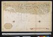
Afteekening van een gedeelte van de kust van Chili in de Zuijd Zee van El Laguia tot C. de la Victoria
Chile Gerard van Keulen
Tabula Magellanica, quâ Tierrae del fuego [...] [Karte], in: Novus Atlas, das ist, Weltbeschreibung, Bd. 2, S. 349.
1 Karte aus Atlas Blaeu, Joan Blaeu, Willem Janszoon
Tabula Magellanica, Qua Tierrae Del Fuego [...] [Karte], in: Novus atlas absolutissimus, Bd. 6, S. 252.
1 Karte aus Atlas Janssonius Offizin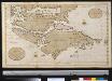
Het zuijdelijkste deel van America vertoonende de Straet Magellanus, de Straat La Maire en Caap de Hoorn in 't groot
Chile Gerard van Keulen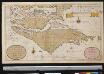
Het Zuijdelijckste deel van America vertoonende de Straet Magelanus, de Straat La Maire en Caap de Hoorn int groodt
Chile Gerard van Keulen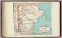
Gobernacion de Santa Cruz.
1 : 2160000 Paz Soldan, Mariano Felipe, 1821-1886
Freti Magellanici ac novi Freti vulgo Le Maire exactissima delineatio
1 : 2000000 [Amsterdam] : [Joannes Janssonius]
Freti Magellanici ac novi Freti vulgo Le Maire exactissima delineatio. [Karte], in: Gerardi Mercatoris et I. Hondii Newer Atlas, oder, Grosses Weltbuch, Bd. 2, S. 419.
1 Karte aus Atlas Mercator, Gerhard und Hondius, Jodocus Jansson, Jan
223. Buenos Aires, Galapagos, Falklands, Tierra del Fuego, Straits of Magellan. The World Atlas.
1 : 250000 USSR (Union of Soviet Socialist Republics).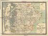
Plano parcial del territorio de Santa Cruz
1 : 681000 Argentina Cobos, Norberto B. Greiner, Ulrich G. Siniscalchi