Maps of Provincia de Magallanes
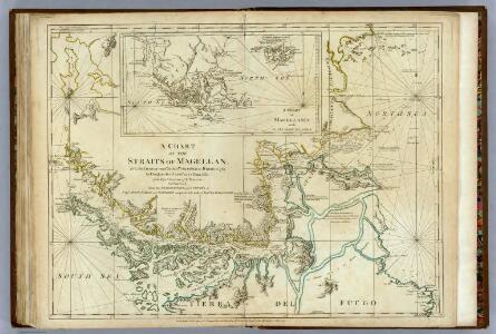
Chart Of The Straits Of Magellan.
1 : 880000 Jefferys, Thomas
Carte du Detroit de Magellan dressée sur les memoires de Mr. de la Morliere Doct.r de Sorbonne dediée à Monseigneur l'évêque de Viviers
Chile Gerard van Keulen

Vue du detroit de la maire entre la Terre de Feu et celle des etats
Ohňová země (Argentina a Chile) Schley, Jacobus van der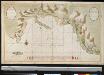
Port Galland of Haven van Gallan geleegen int midde van de Straet van Magelanus aen de Noordwal
Chile Grout Gerard van Keulen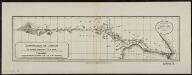
Demarcacion de limites entre la Republica argentina y la de Chile. Region meridional de la Patagonia
1 : 500000 Argentine. Oficina de Límites Internacionales [Buenos Aires ?] :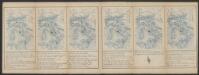
Exquisita & magno aliquot mensium periculo lustrata et iam retecta Freti Magellanici Facies. [...] [Karte], in: Gerardi Mercatoris Atlas, sive, Cosmographicae meditationes de fabrica mundi et fabricati figura, S. 562.
1 Karte aus Atlas Mercator, Gerhard Montanus, Petrus
Tabula Magellanica, quâ Tierrae del fuego [...] [Karte], in: Novus Atlas, das ist, Weltbeschreibung, Bd. 2, S. 349.
1 Karte aus Atlas Blaeu, Joan Blaeu, Willem Janszoon
Tabula Magellanica, Qua Tierrae Del Fuego [...] [Karte], in: Novus atlas absolutissimus, Bd. 6, S. 252.
1 Karte aus Atlas Janssonius Offizin
TABVLA MAGELLANICA, | quâ Tierræ del fuego, cum celeberrimis fretis a | F. Magellano et I. Le Maire detectis novissima et | accuratissima descriptio exhibetur.
[Amsterdam : Joan Blaeu]
Tabula Magellanica, quâ Tierrae del Fuego [...] [Karte], in: Le théâtre du monde, ou, Nouvel atlas contenant les chartes et descriptions de tous les païs de la terre, Bd. 2, S. 344.
1 Karte aus Atlas Blaeu, Willem Janszoon und Blaeu, Joan Blaeu, Willem Janszoon
Freti Magellanici ac novi Freti vulgo Le Maire exactissima delineatio
1 : 2000000 [Amsterdam] : [Joannes Janssonius]
Freti Magellanici ac novi Freti vulgo Le Maire exactissima delineatio. [Karte], in: Gerardi Mercatoris et I. Hondii Newer Atlas, oder, Grosses Weltbuch, Bd. 2, S. 419.
1 Karte aus Atlas Mercator, Gerhard und Hondius, Jodocus Jansson, Jan
[Terra del Fuego]
1 : 875000 [S.l. : s.n.]
223. Buenos Aires, Galapagos, Falklands, Tierra del Fuego, Straits of Magellan. The World Atlas.
1 : 250000 USSR (Union of Soviet Socialist Republics).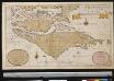
Het Zuijdelijckste deel van America vertoonende de Straet Magelanus, de Straat La Maire en Caap de Hoorn int groodt
Chile Gerard van Keulen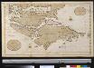
Het zuijdelijkste deel van America vertoonende de Straet Magellanus, de Straat La Maire en Caap de Hoorn in 't groot
Chile Gerard van Keulen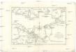
Détroit de Magellan avec les plans des principaux ports, bayes & c. de ce détroit
1 : 1780000 Argentina Bonne, Rigobert André
Partie, la Patagonie. Amer. Merid. 40.
1 : 1641836 Vandermaelen, Philippe, 1795-1869
[Chart of Tierra del Fuego and the Strait of Magellan]
1 : 1
Kaart van Straat Magellaan, Straat Le Maire, het Vuurland en Kaap Hoorn / [getekend door] R. van Wijk
Dordrecht : J. de Vos
Kaart van Straat Magellaan, Straat Le Maire, het Vuurland en Kaap Hoorn
1 : 1400000 R. van Wijk Jacobus Zn. del. [Dordrecht] : [J. de Vos]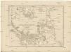
Karte der Magellanischen Strasse
Falklandy De la Cruz Cano y Olmedilla, Juan Bougainville, Jean-Pierre de F.A. Schraembl
Freti Magellanici ac novi freti vulgo le Maire
1 : 2050000
(Mapa de la Republica de Chile 14)
1 : 11000000 Pissis, Aime, 1812-1889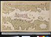
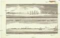
Afteekening van een gedeelte der Straet Magellanus, vertoonende t eijland Catherin of I. Louis le Grand
Chile Gerard van Keulen
Tabula Magellanica, quâ Tierrae del fuego [...] [Karte], in: Theatrum orbis terrarum, sive, Atlas novus, Bd. 2, S. 359.
1 Karte aus Atlas Blaeu, Joan Blaeu, Willem Janszoon