Maps of Tierra Del Fuego


Kaart van Straat Magellaan, Straat Le Maire, het Vuurland en Kaap Hoorn
1 : 1400000 R. van Wijk Jacobus Zn. del. [Dordrecht] : [J. de Vos]
Freti Magellanici ac novi Freti vulgo Le Maire exactissima delineatio. [Karte], in: Gerardi Mercatoris et I. Hondii Newer Atlas, oder, Grosses Weltbuch, Bd. 2, S. 419.
1 Karte aus Atlas Mercator, Gerhard und Hondius, Jodocus Jansson, Jan
Freti Magellanici ac novi Freti vulgo Le Maire exactissima delineatio
1 : 2000000 [Amsterdam] : [Joannes Janssonius]
223. Buenos Aires, Galapagos, Falklands, Tierra del Fuego, Straits of Magellan. The World Atlas.
1 : 250000 USSR (Union of Soviet Socialist Republics).
Freti Magellanici ac novi freti vulgo le Maire
1 : 2050000
Kaart van Straat Magellaan, Straat Le Maire, het Vuurland en Kaap Hoorn / [getekend door] R. van Wijk
Dordrecht : J. de Vos
[Chart of Tierra del Fuego and the Strait of Magellan]
1 : 1
Het Zuijdelijckste deel van America vertoonende de Straet Magelanus, de Straat La Maire en Caap de Hoorn int groodt
Chile Gerard van Keulen
Détroit de Magellan avec les plans des principaux ports, bayes & c. de ce détroit
1 : 1780000 Argentina Bonne, Rigobert André
Gobernacion de la Tierra del Fuego, Islas Malvinas.
1 : 1800000 Paz Soldan, Mariano Felipe, 1821-1886
Plan del Rio Negro
1 : 588200 Rio Negro (Argentina)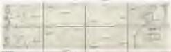
Mapa poříčí řeky Chubutu v stejnojmenném území Patagonie (Republika Argentina)
Patagonie (Argentina a Chile) Tůma, Emil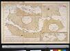
Carte du Detroit de Magellan dressée sur les memoires de Mr. de la Morliere Doct.r de Sorbonne dediée à Monseigneur l'évêque de Viviers
Chile Gerard van Keulen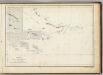
(Mapa de la Republica de Chile 15)
1 : 11000000 Pissis, Aime, 1812-1889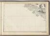
(Mapa de la Republica de Chile 14)
1 : 11000000 Pissis, Aime, 1812-1889

Demarcacion de limites con Chile. Tierra del Fuego
1 : 500000 Argentine. Oficina de Límites Internacionales [Buenos Aires ?] :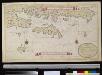
Afteekening van de Nassausche Voert [!] en t'Hermitens Eijlandt geleegen aen de Suijthoek van America, met alle dessels gelegentheden int groodt
Chile Gerard van Keulen
Vue du detroit de la maire entre la Terre de Feu et celle des etats
Ohňová země (Argentina a Chile) Schley, Jacobus van der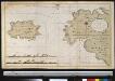
Afteekening van de Straet van Le Maire geleegen aent uijt eijnde van Zuijdt America, tussen Terre de Feu en het Staaten Land, op 55 grade 45 min. Z.breete
Argentina Gerard van Keulen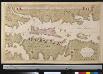
Afteekening van een gedeelte der Straet Magellanus, vertoonende t eijland Catherin of I. Louis le Grand
Chile Gerard van Keulen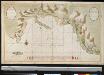
Port Galland of Haven van Gallan geleegen int midde van de Straet van Magelanus aen de Noordwal
Chile Grout Gerard van Keulen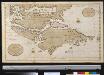
Het zuijdelijkste deel van America vertoonende de Straet Magellanus, de Straat La Maire en Caap de Hoorn in 't groot
Chile Gerard van Keulen
[Terra del Fuego]
1 : 875000 [S.l. : s.n.]
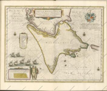
Tabula Magellanica, quâ Tierrae del fuego [...] [Karte], in: Novus Atlas, das ist, Weltbeschreibung, Bd. 2, S. 349.
1 Karte aus Atlas Blaeu, Joan Blaeu, Willem Janszoon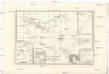
Extrémité méridionale de l'Amérique
Jižní Amerika Bonne, Rigobert André
Tabula Magellanica, Qua Tierrae Del Fuego [...] [Karte], in: Novus atlas absolutissimus, Bd. 6, S. 252.
1 Karte aus Atlas Janssonius Offizin
TABVLA MAGELLANICA, | quâ Tierræ del fuego, cum celeberrimis fretis a | F. Magellano et I. Le Maire detectis novissima et | accuratissima descriptio exhibetur.
[Amsterdam : Joan Blaeu]