Maps of Serra Do Mar

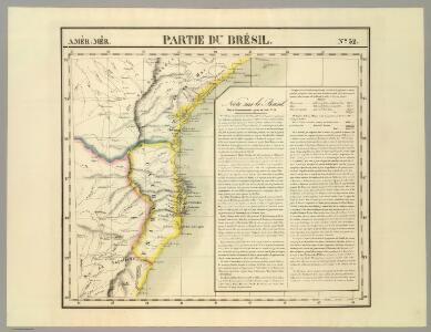
Partie du Bresil. Amer. Merid. 32.
1 : 1641836 Vandermaelen, Philippe, 1795-1869
Nieuwe afteekening van het eijland Ste Catharina geleegen aen de kust van Brazil, op 27 graden 30 min. Zuijder Breete
Brazil Gerard van Keulen
Barra de Santos
1 : 100000 Comissão Geográfica e Geológica. São Paulo, Brésil São Paulo : Weiszflog Irmaos
Een gedeelte van de kust van Brazilia tussen C. St. Thome en I. St. Catharina
Brazil Gerard van Keulen
Porto de San Vincente aen de kust van Brazilia leggende op 24 graade breete int grood bestek
Brazil Gerard van Keulen
L. Das kaiserthum Brasilien. Provinz 13-14, 15, 19. Q. Die Rep. Montevideo
1 : 2000000 Schlieben, Wilhelm Ernst August von (1781 - 1839)
157-58. Brasile Meridionale, Uruguay.
1 : 3000000 Touring club italiano
Rio De La Plata. Brazil - Sao Paulo - Rio De Janeiro. Pergamon World Atlas.
1 : 2500000 Polish Army Topography Service
South America 4.
1 : 6969600 Letts, Son & Co.
Brasil du Sud.
1 : 6000000 Vivien St Martin, L.
S. Brazil, Paraguay, Uruguay.
1 : 6630000 Society for the Diffusion of Useful Knowledge (Great Britain)
A map of Brazil, now called New Portugal
1 : 9600000 Carey, Mathew, 1760-1839 M. Carey
Argentina, Chile, &c.
1 : 5000000 John Bartholomew & Co.
Brazil, Paraguay, and Uruguay (southern half).
1 : 5020000 Rand McNally and Company
[Süd-Amerika in 6 Blättern, Blatt 4]
Adolf Stieler's Handatlas über alle Theile der Erde und über das Weltgebäude Stieler, Adolf Justus Perthes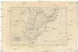
Brésil et pays des Amazones, avec le gouvernement de Buenos-Aires
1 : 10700000 Amazonka-oblast Bonne, Rigobert André
Brazil - East - Central. Pergamon World Atlas.
1 : 5000000 Polish Army Topography Service
South America 6.
1 : 2800000 Arrowsmith, Aaron
Novus Brasiliae Typus [Karte] [Baya de todos os Sanctos] [Nebenkarte], in: Novus Atlas, das ist, Weltbeschreibung, Bd. 2, S. 343.
1 Karte aus Atlas Blaeu, Joan Blaeu, Willem Janszoon
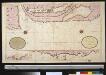
Een gedeelte van de kust van Brazilia tussen I. St. Catharina en C. St. Anthonio
Uruguay Gerard van Keulen
Estado de Sao Paulo, mappa geologico physico politico e economico
1 : 1000000 Paris : Girard et Barrère
Carta de progresso da Commissao Geographica e Geologica de S. Paulo
1 : 2000000 Comissão Geográfica e Geológica. São Paulo, Brésil [São Paulo] : Commissão Geográphica e Geológica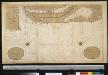
De kust van Brazilia tussen I. St. Catharina en C. St. Anthonio
Uruguay Gerard van Keulen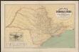
Carta geral do estado de Sao Paulo. Organizada pela Commissao Geographica e Geologica
1 : 1000000 Comissão Geográfica e Geológica. São Paulo, Brésil São Paulo : Weiszflog Irmãos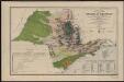
Carta geral do estado de Sao Paulo. Com indicaçoes sobre a agricultura, commercio, instrucçao publica, industria e colonisaçao
1 : 2000000 Comissão Geográfica e Geológica. São Paulo, Brésil [São Paulo] : Commissão Geográphica e Geológica
Carte Historique de la Province des Missions et des Établissements des Jésuites sur le Parana et l'Uruguay
1 : 2000000 Description géographique et statistique de la Confédération Argentine Martin de Moussy, Victor Librairie de Firmin Didot frères, fils et Cie
Paraguay, pays adjacants.
1 : 8600000 Bonne, Rigobert, 1727-1794
La Plata - Chili (sic) and Southern Brazil.
1 : 8400000 Sharpe, J.