Maps of Nile Delta

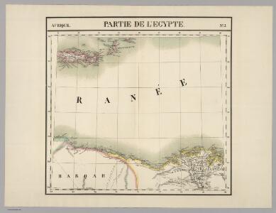
Partie, l'Egypte. Afrique 5.
1 : 1641836 Vandermaelen, Philippe, 1795-1869
Feuille 47 (E VII), uit: Carte géologique internationale de l'Europe : la carte, votée au congrès géologique international de Bologne en 1881, est exécutée conformément aux décisions d'une commission internationale, avec le concours des gouvernements, sous le dir. de M.M. Beyrich et Hauchecorne
Annotatie: Blad 48 gamme des couleurs; blad 49: bladwijzer en titelblad Heinrich Ernst Beyrich 1815-1896; Wi. Hauchecorne Berlin : Reimer / (Berlin: Institut lithographique)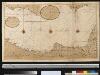
De kuste van Egipten en Barbaria beginnende van Jaffa tot I: Soliman int groot
Egypt Gerard van Keulen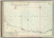
Carte De La Mer Mediterranee. IX.
Roux, Joseph
Europe 1:1.000.000
1 : 1000000 Kréta (Řecko) Geographical Section, General Staff
Feuille No. 7, uit: Carte de la Turquie d'Asie (moins l'Arabie) / dessiné et héliogravé au Service géographique de l'Armée
1 : 1000000 titelvariant: Turquie d'Asie; Annotatie: Titel boven de kaart: Turquie d'Asie; Bl. genummerd 1-4 en 7-10; Met lijst van de meest gebruikte woorden op de kaart vertaald uit het Turks, Arabisch en Perzisch; Annotatie geografische gegevens: Inzetkrt. op bl. 9: Plan de Jérusalem et de ses environs, Plan d'Alep, Plan de Damas et de ses faubourgs, Plan de Beyrout et de ses environs (alle 1:50.000) Service géographique de l'Armée [S.l. : Service géographique de l'Armée]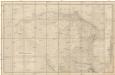
Carte hydrographique de la Basse Égypte et d'une partie de l'isthme de Suez
1 : 250000 Egypt Linant de Bellefonds, Louis Maurice Adolphe Schwaerzlé, J. Dépôt général de la guerre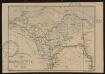
Carte de la Basse Egypte
1 : 1500000 Société de géographie de Toulouse Toulouse : Lith. Cussan Fils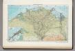
163. Nile Delta, Suez Canal, Alexandria. The World Atlas.
1 : 750000 USSR (Union of Soviet Socialist Republics).
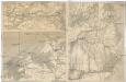
Das Nil - Delta und der Sues-Kanal
[Nil-Delta]
1 : 1000000 Alexandrie (Egypt) Mitterwallner, J.
Das Nil-Delta und der Sues-Kanal
1 : 800000 Egypt Ed. Hölzel
Communications map of lower Egypt and the Fayum
1 : 300000 Egypt Survey of Egypt
Carte de la Basse, Égypte et du Canal Maritime de Suez
1 : 500000 Suezský průplav (Egypt) Desbuissons, Edouard Méa, Paul E. Andriveau-Coujon
Europa.
1 : 15000000 Petermann, A.
Plan of the Operations of the British & Ottoman Forces in Egypt, From the 8th. of March to the 2d. of Sept.r 1801, when the French were Finally expelled from that Country
Neele, Samuel John Arrowsmith
Das Nil-Delta und der Sues-Kanal
1 : 800000 Egypt Eduard Hölzel
Carte De L'Egypte et des Postes Militaires occupés et Fortifiés par les Français sous les ordres du Géneral en Chef Bounaparte, depuis leur invasion le 1. Juillet 1798, jusqu'à ce jour; Dressée d'après les relations fidelles des Chefs interceptées, et sur le compte qui en a eté rendu par les deserteurs
Kauffer, François
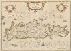
INSULA | CANDIA | olim | CRETA.
N. Visscher exc.
Candia olim Creta
1 : 3830000 Kréta (Řecko)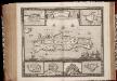
Insula Candia ejusque fortificatio / edita per F. de Wit
1 : 475000 Annotatie: Rechtsboven: 23; Origineel is Blad 173 in atlas factice; Annotatie geografische gegevens: Schaalstok: 15 Milliaria Germanica communia; Inzetkaarten van: Canea, Candia, Spina Longa, Retimo, Thine, Suda Frederick de Wit 1630-1706 Amsterdam : Gedruckt by Frederick de Wit inde Kalverstraet inde Witte Paskaert
CANDIA, | olim | CRETA
[Amsterdam : Joan Blaeu]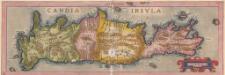
Candia Insula. [Karte], in: Theatrum orbis terrarum, S. 246.
1 Karte aus Atlas Ortelius, Abraham

Candia cum Insulis aliquot circa Graeciam[:] [Zypern] [Karte], in: Gerardi Mercatoris et I. Hondii Newer Atlas, oder, Grosses Weltbuch, Bd. 2, S. 336.
1 Karte aus Atlas Mercator, Gerhard und Hondius, Jodocus Jansson, Jan
Candia cum Insulis aliquot circa Graeciam[:] [Zypern] [Karte], in: Gerardi Mercatoris Atlas, sive, Cosmographicae meditationes de fabrica mundi et fabricati figura, S. 493.
1 Karte aus Atlas Mercator, Gerhard Montanus, Petrus
Candia, olim Creta. [Karte], in: Le théâtre du monde, ou, Nouvel atlas contenant les chartes et descriptions de tous les païs de la terre, Bd. 3, S. 309.
1 Karte aus Atlas Blaeu, Willem Janszoon und Blaeu, Joan Blaeu, Willem Janszoon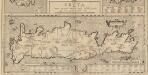
Creta Iovis magni, medio iacet insula ponto. [Karte], in: Theatrum orbis terrarum, S. 520.
1 Karte aus Atlas Ortelius, Abraham Vrients, Jan Baptista
Insula Candia olim Creta
Kréta (Řecko) Weiland, Karl Ferdinand Visscher, Nicolaus N. Visscher