Maps of Crete

Europe 1:1.000.000
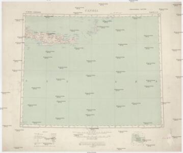
1 : 1000000 Kréta (Řecko) Geographical Section, General Staff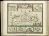
[83][83] Insula Candia ..., uit: Atlas sive Descriptio terrarum orbis
Annotatie: Gedigitaliseerde versie. Amsterdam. Heiloo : Picturae (vervaardiger), 2015. tiff-bestand. Gedigitaliseerd: 07-01-2015; Origineel: Universiteitsbibliotheek Vrije Universiteit (XL.05127.-) ; Netherlands; Titelpagina ontbreekt Wit, Frederik de Amsterdam : Frederick de Wit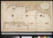
Een gedeelte van het eijland Candia vertoonende de de Noord Oost zijde
Greece Gerard van Keulen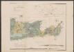
Carte orographique et géognostique de l'île de Crête
1 : 300000 Ostblatt Raulin, Victor R. Janson
Candia olim Creta
1 : 3830000 Kréta (Řecko)
Greece 1:250, 000, Iraklion (Candia)
Greece 1:250,000 , Series GSGS 4410. Great Britain. War Office. [London] : War Office
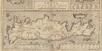
CANDIA, | olim | CRETA
[Amsterdam : Joan Blaeu]
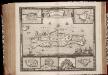
Insula Candia ejusque fortificatio / edita per F. de Wit
1 : 475000 Annotatie: Rechtsboven: 23; Origineel is Blad 173 in atlas factice; Annotatie geografische gegevens: Schaalstok: 15 Milliaria Germanica communia; Inzetkaarten van: Canea, Candia, Spina Longa, Retimo, Thine, Suda Frederick de Wit 1630-1706 Amsterdam : Gedruckt by Frederick de Wit inde Kalverstraet inde Witte Paskaert
INSULA | CANDIA | olim | CRETA.
N. Visscher exc.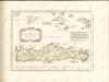

Isle et royaume de Candie
1 : 810000 Kréta (Řecko) Sanson, Nicolas Cordier, Louis Pierre Mariette
Candia cum Insulis aliquot circa Graeciam[:] [Zypern] [Karte], in: Gerardi Mercatoris et I. Hondii Newer Atlas, oder, Grosses Weltbuch, Bd. 2, S. 336.
1 Karte aus Atlas Mercator, Gerhard und Hondius, Jodocus Jansson, Jan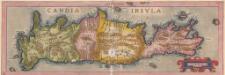
Candia Insula. [Karte], in: Theatrum orbis terrarum, S. 246.
1 Karte aus Atlas Ortelius, Abraham
Tabula Neoterica Crete Sive Candie Insule [Karte], in: Claudii Ptolemei viri Alexandrini mathematice discipline philosophi doctissimi geographie opus [...], S. 281.
1 Karte aus Atlas Waldseemüller, Martin [und Ptolemaeus, Claudius] Übelin, Georg
Creta Iovis magni, medio iacet insula ponto. [Karte], in: Theatrum orbis terrarum, S. 520.
1 Karte aus Atlas Ortelius, Abraham Vrients, Jan Baptista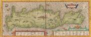
Creta Iovis magni, medio iacet insula ponto. [Karte], in: Theatrum orbis terrarum, S. 416.
1 Karte aus Atlas Ortelius, Abraham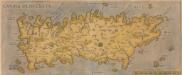
[Candia, Olim Creta.] [Karte], in: Theatrum orbis terrarum, S. 93.
1 Karte aus Atlas Ortelius, Abraham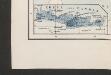
[Nebenkarte Kreta] Ethnographische Karte der europäischen Türkei und ihrer Dependenzen zu Anfang des Jahres 1877
Griechenland Kreta Ethnische Gruppe Sax, Carl
Candia cum Insulis aliquot circa Graeciam[:] [Zypern] [Karte], in: Gerardi Mercatoris Atlas, sive, Cosmographicae meditationes de fabrica mundi et fabricati figura, S. 493.
1 Karte aus Atlas Mercator, Gerhard Montanus, Petrus
Candia, olim Creta. [Karte], in: Le théâtre du monde, ou, Nouvel atlas contenant les chartes et descriptions de tous les païs de la terre, Bd. 3, S. 309.
1 Karte aus Atlas Blaeu, Willem Janszoon und Blaeu, Joan Blaeu, Willem Janszoon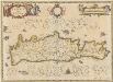
Candia olim Creta. [Karte], in: Novus atlas absolutissimus, Bd. 5, S. 294.
1 Karte aus Atlas Janssonius Offizin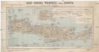
Die Insel Candia oder Creta
1 : 500000 Kréta (Řecko : ostrov) Dietrich Reimer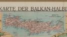
[Kreta]
Griechenland Kreta Osmanisches Reich
Candia cum insulis aliquot circa Græciam
1 Karte : Kupferdruck ; 22 x 46 cm, Bildgrösse 34 x 48 cm Mercator; Hondius Henricus Hondius
Candia cum insulis aliquot circa Græciam
1 Karte : Kupferdruck ; 22 x 46 cm, Bildgrösse 34 x 48 cm Mercator s.n.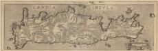
Candia Insula. [Karte], in: Theatrum orbis terrarum, S. 341.
1 Karte aus Atlas Ortelius, Abraham Vrients, Jan Baptista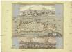
Insula Candia olim Creta
Kréta (Řecko) Weiland, Karl Ferdinand Visscher, Nicolaus N. Visscher