Maps of El Daba
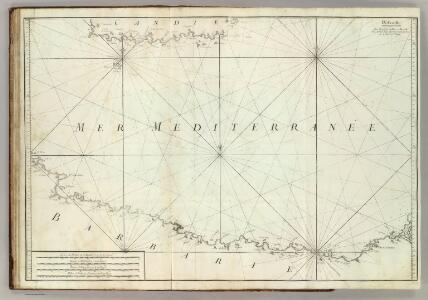
Carte De La Mer Mediterranee. IX.
Roux, Joseph
Partie, l'Egypte. Afrique 5.
1 : 1641836 Vandermaelen, Philippe, 1795-1869
Europe 1:1.000.000
1 : 1000000 Kréta (Řecko) Geographical Section, General Staff
Feuille No. 7, uit: Carte de la Turquie d'Asie (moins l'Arabie) / dessiné et héliogravé au Service géographique de l'Armée
1 : 1000000 titelvariant: Turquie d'Asie; Annotatie: Titel boven de kaart: Turquie d'Asie; Bl. genummerd 1-4 en 7-10; Met lijst van de meest gebruikte woorden op de kaart vertaald uit het Turks, Arabisch en Perzisch; Annotatie geografische gegevens: Inzetkrt. op bl. 9: Plan de Jérusalem et de ses environs, Plan d'Alep, Plan de Damas et de ses faubourgs, Plan de Beyrout et de ses environs (alle 1:50.000) Service géographique de l'Armée [S.l. : Service géographique de l'Armée]
Egypt and Cyrenaica 1:250,000, Salum-Torbruch
Egypt and Cyrenaica 1:250,000 , Series GSGS 4386. Great Britain. Army. Middle East Command. [London] : War Office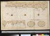
Een gedeelte vant eijland Candia vertoonende de Zuyd west kust
Greece Gerard van Keulen
Candia olim Creta
1 : 3830000 Kréta (Řecko)
CANDIA, | olim | CRETA
[Amsterdam : Joan Blaeu]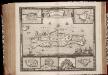
Insula Candia ejusque fortificatio / edita per F. de Wit
1 : 475000 Annotatie: Rechtsboven: 23; Origineel is Blad 173 in atlas factice; Annotatie geografische gegevens: Schaalstok: 15 Milliaria Germanica communia; Inzetkaarten van: Canea, Candia, Spina Longa, Retimo, Thine, Suda Frederick de Wit 1630-1706 Amsterdam : Gedruckt by Frederick de Wit inde Kalverstraet inde Witte Paskaert

Candia cum Insulis aliquot circa Graeciam[:] [Zypern] [Karte], in: Gerardi Mercatoris et I. Hondii Newer Atlas, oder, Grosses Weltbuch, Bd. 2, S. 336.
1 Karte aus Atlas Mercator, Gerhard und Hondius, Jodocus Jansson, Jan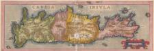
Candia Insula. [Karte], in: Theatrum orbis terrarum, S. 246.
1 Karte aus Atlas Ortelius, Abraham
INSULA | CANDIA | olim | CRETA.
N. Visscher exc.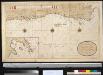
Een gedeelte van het eijland Candia vertoonende de Zuijd Oost zijden
Greece Gerard van Keulen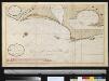
Afteekening van een gedeelte van de kust van Egipten vertoonende de haven van Alexandria ent land daer beoosten
Egypt Gerard van Keulen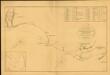
Chart of the Coast of Egypt, from Alexandria to the Western Branch of the Nile
Chart of the Coast of Egypt, from Alexandria to the Western Branch of the Nile; with the Bay of Aboukir, shewing the position of the French and English Fleets, at the Battle of the Nile, August 1, 1798. London : A. Arrowsmith.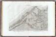
37 Alexandrie.
1 : 100000 Jacotin, Pierre, 1765-1827
39 Ile d'Abouqir.
1 : 100000 Jacotin, Pierre, 1765-1827
38 El Hammam.
1 : 100000 Jacotin, Pierre, 1765-1827
Tobruch, Libya 1:50,000
Tobruch 1:50, 000, Series MDR 537. Great Britain. Army. Royal Engineers. Field Survey Company, 512th. [Cairo] : [Survey Directorate, Middle East]
Tobruch, Libya 1:50,000, Acroma
Tobruch 1:50, 000, Series MDR 537. Great Britain. Army. Royal Engineers. Field Survey Company, 512th. [Cairo] : [Survey Directorate, Middle East]
Tobruch, Libya 1:50,000, El Adem
Tobruch 1:50, 000, Series MDR 537. Great Britain. Army. Royal Engineers. Field Survey Company, 512th. [Cairo] : [Survey Directorate, Middle East]
Plan de la Bataille d'Abukir à l'Ambouchure du Nil donnée le 1. 2. et 3. d'Aoust 1798 par la Flotte des S. M. Brittanique commandée par l'Admiral Nelson, et la Flotte Francoise sous les ordres de l'Admiral Bruis
Artaria
Stadtplan von Alexandria, 1:15,000
Stadtplan von Alexandria, 1:15,000. Germany. Luftwaffe Berlin : Luftwaffe.
Map of Mersa Matruh & Râs Allem Rum
1 : 25000 Survey department Egypt
Piano dei due porti di Allesandria, e posezione della squadra Turco-Egizia in Agosto 1831
1 : 43000 Alexandrie (Egypt)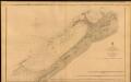
The Port of Alexandria, Egypt
The Port of Alexandria. Surveyed by Lieut. E. W. Brooker, etc. 1857. [Admiralty Chart] London
Alexandria ... Dikheila Extension. Scale 1 : 10,000
Alexandria ... Dikheila Extension. Scale 1 : 10,000. [El Giza] : Survey of Egypt.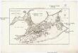
Geometrischer Grundiss der Stadt Alexandria
1 : 158000 Alexandrie (Egypt) Ausfeld, Johann Carl Gleditsch