Maps of Guiana Shield

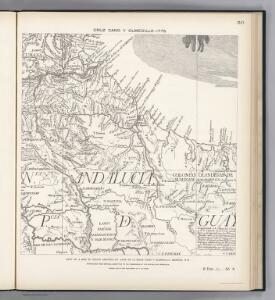
Facsimile: Part of South America by Cruz Cano Y Olmedilla.
Cruz Cano y Olmedilla, Juan de la, d. 1790
Facsimile: Part of Venezuela, Guiana by Arrowsmith.
1 : 4850000 Arrowsmith, John
Partie, Colombie. Amer. Merid. 6.
1 : 1641836 Vandermaelen, Philippe, 1795-1869
British Guayana.
1 : 2800000 Tallis, J. & F.
Orinoco.
1 : 2650000 Restrepo, Jose Manuel, 1781-1863
Carta del Canton de Upata, Provincia de Guayana.
1 : 1300000 Codazzi, Agustin, 1793-1859
Carta del Canton de Rio Negro, Provincia de Guayana.
1 : 1300000 Codazzi, Agustin, 1793-1859
Übersicht der bekannteren Gabeltheilungen des Strömenden Wassers
Erster Band, enthaltend in vier Abtheilungen die Erscheinungen der anorganischen Natur: 1. Meteorologie und Klimatographie. 2. Hydrologie und Hydrographie. 3. Geologie. 4. Tellurischer Magnetismus Humboldt, Alexander von Verlag von Justus Perthes
Carta del Canton de Angostura, Provincia de Guayana.
1 : 1300000 Codazzi, Agustin, 1793-1859
Partie du Bresil. Amer. Merid. 10.
1 : 1641836 Vandermaelen, Philippe, 1795-1869
Map of British Guiana.
1 : 1520640 Arrowsmith, John
[Land- und Wasserteilung]
Atlas der Hydrographie Berghaus, Hermann Justus Perthes
Facsimile: Part of the Great Colonial Map by Schomburgk.
1 : 1430000 Brown, Charles B.
Ubersicht der bekannteren Gabeltheilungen des Stromenden Wassers.
Berghaus, Heinrich
A new chart of the coast of Guyana from Rio Orinoco to River Berbice.
1 : 550000 Jefferys, Thomas
Grand View of European Occupation, 1597-1803 (1814).
1 : 2027520 Venezuela-British Guiana Boundary Commission
European Occupation in 1626.
1 : 2027520 Venezuela-British Guiana Boundary Commission
European Occupation in 1724.
1 : 2027520 Venezuela-British Guiana Boundary Commission
European Occupation in 1674.
1 : 2027520 Venezuela-British Guiana Boundary Commission
European Occupation in 1756.
1 : 2027520 Venezuela-British Guiana Boundary Commission
European Occupation in 1796.
1 : 2027520 Venezuela-British Guiana Boundary Commission
European Occupation in 1648.
1 : 2027520 Venezuela-British Guiana Boundary Commission
European Occupation in 1773.
1 : 2027520 Venezuela-British Guiana Boundary Commission
European Occupation in 1703.
1 : 2027520 Venezuela-British Guiana Boundary Commission
European Occupation in 1803 (1814).
1 : 2027520 Venezuela-British Guiana Boundary Commission
European Occupation in 1597.
1 : 2027520 Venezuela-British Guiana Boundary Commission
Facsimile: Part of South America by Arrowsmith.
1 : 2800000 Arrowsmith, John
Drainage Basins.
1 : 2027520 Venezuela-British Guiana Boundary Commission
Forests and Savannas.
1 : 2027520 Venezuela-British Guiana Boundary Commission