Maps of Bolivia
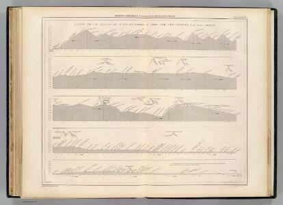
Coupe de la route de Buenos-Ayres a Lima.
1 : 1949000 Martin de Moussy, V. (Victor), 1810-1869
Mapa de Bolivia / tomado de la Carta general y compilación de datos hecha por el ingeniero auxiliar de Obras Públicas Javier Valdez Reinoso
1 : 2400000 1 Mapa, col. Valdez Reinoso, Javier Arnó Hermanos , Hernich y Ca. (Barcelona)
Richard Mayer's commercial map of Northern Chili, Bolivia, & southern Peru
1 : 1000000
West Coast of South America.
Fullarton, A. & Co.
South America 3.
1 : 2800000 Arrowsmith, Aaron
Een gedeelte van de Zuijdt-Zee van Quilca tot Po. El Guasco geleegen aen de kust van Peru
Chile Gerard van Keulen
Carte des Provinces de Catamarca de Rucuman et des régions voisines
1 : 2000000 Description géographique et statistique de la Confédération Argentine Martin de Moussy, Victor Librairie de Firmin Didot frères, fils et Cie
Catamarca et Tucuman.
1 : 1850000 Martin de Moussy, V. (Victor), 1810-1869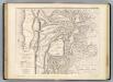
Carte, provinces de Salta et Jujuy, partie de la Bolivie.
1 : 1850000 Martin de Moussy, V. (Victor), 1810-1869
Carte des Provinces de Salta et de Jujuy et d'une partie de la Bolivie
1 : 2000000 Description géographique et statistique de la Confédération Argentine Martin de Moussy, Victor Librairie de Firmin Didot frères, fils et Cie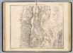
Carte, provinces de La Rioja et San Juan.
1 : 1850000 Martin de Moussy, V. (Victor), 1810-1869
Partie du Perou. Amer. Merid. 25.
1 : 1641836 Vandermaelen, Philippe, 1795-1869
Carte des Provinces de la Rioja de San Juan et des régions voisines
1 : 2000000 Description géographique et statistique de la Confédération Argentine Martin de Moussy, Victor Librairie de Firmin Didot frères, fils et Cie
Partie du Chili. Amer. Merid. 29.
1 : 1641836 Vandermaelen, Philippe, 1795-1869
Partie du Perou. Amer. Merid. 21.
1 : 1641836 Vandermaelen, Philippe, 1795-1869
Partie, la Plata. Amer. Merid. 30.
1 : 1641836 Vandermaelen, Philippe, 1795-1869
West Coast of South America. Peru and Bolivia (mostly Chile) ... Quilca to Cobija.
1 : 1230000 Berghaus, Henry
Mapa del sur del Peru y parte de Bolivia
1 : 1000000 Arequipa : J.L. Villanueva
Partie du Perou. Amer. Merid. 20.
1 : 1641836 Vandermaelen, Philippe, 1795-1869
Provincia de La Rioja
1 : 1250000 Seelstrang, Arthur Eduard von 1838-1896 Buenos-Aires : J. Ruland
La Paz : South America, 1:1,000,000
1 : 1000000
Carta de la rejion salitrera comprendida entre los paralelos 19° y 27°30' lat. sur
1 : 500000 (Chili) Delegacion fiscal de salitreras Antofagasta : Delegacion fiscal de salitreras
Puno - Rio Beni : South America, 1:1,000,000
1 : 1000000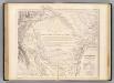
Carte, Province de Santiago del Estero, Grand Chaco.
1 : 1850000 Martin de Moussy, V. (Victor), 1810-1869
Carte de la Province de Santiago del Estero et du Territoire Indien du Nord ou Grand Chaco
1 : 2000000 Description géographique et statistique de la Confédération Argentine Martin de Moussy, Victor Librairie de Firmin Didot frères, fils et Cie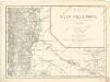
Map of the river Pilcomayo

Plano Nuevo de los Territorios del Chaco argentino
1 : 800000 Jorge Rohde Buenos Aires : G. Kraft
Carte des Provinces de Cordova de San Luis et des régions voisines
1 : 2000000 Description géographique et statistique de la Confédération Argentine Martin de Moussy, Victor Librairie de Firmin Didot frères, fils et Cie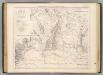
Carte des provinces de Cordova et San Luis.
1 : 1850000 Martin de Moussy, V. (Victor), 1810-1869