Maps of Salta
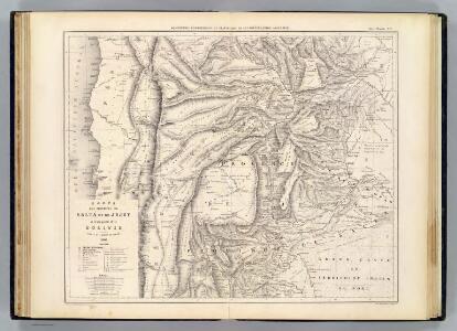
Carte, provinces de Salta et Jujuy, partie de la Bolivie.
1 : 1850000 Martin de Moussy, V. (Victor), 1810-1869
Carte des Provinces de Salta et de Jujuy et d'une partie de la Bolivie
1 : 2000000 Description géographique et statistique de la Confédération Argentine Martin de Moussy, Victor Librairie de Firmin Didot frères, fils et Cie
Partie du Perou. Amer. Merid. 25.
1 : 1641836 Vandermaelen, Philippe, 1795-1869
Provincia de Salta.
1 : 1800000 Paz Soldan, Mariano Felipe, 1821-1886
Carta de la rejion salitrera comprendida entre los paralelos 19° y 27°30' lat. sur
1 : 500000 (Chili) Delegacion fiscal de salitreras Antofagasta : Delegacion fiscal de salitreras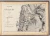
Mapa de la Republica de Chile (1)
1 : 11000000 Pissis, Aime, 1812-1889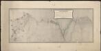
Plano topografico de la region norte argentina limitrofe con Bolivia
1 : 575000 (Argentine) Comision Argentina Demarcadora de Limites con Bolivia [Buenos Aires] :
Provincias de Jujuy y Tucuman.
1 : 1800000 Paz Soldan, Mariano Felipe, 1821-1886
Demarcacion de limites con Chile. Puna de Atacama.
1 : 500000 Argentine. Oficina de Límites Internacionales [Buenos Aires ?] :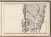
(Mapa de la Republica de Chile 2)
1 : 11000000 Pissis, Aime, 1812-1889
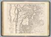
Map of the river Pilcomayo

West Coast of South America.
Fullarton, A. & Co.
South America 3.
1 : 2800000 Arrowsmith, Aaron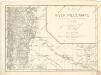
Map of the river Pilcomayo

Carte des Provinces de Catamarca de Rucuman et des régions voisines
1 : 2000000 Description géographique et statistique de la Confédération Argentine Martin de Moussy, Victor Librairie de Firmin Didot frères, fils et Cie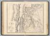
Catamarca et Tucuman.
1 : 1850000 Martin de Moussy, V. (Victor), 1810-1869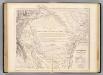
Carte, Province de Santiago del Estero, Grand Chaco.
1 : 1850000 Martin de Moussy, V. (Victor), 1810-1869
West Coast of South America. Peru and Bolivia (mostly Chile) ... Quilca to Cobija.
1 : 1230000 Berghaus, Henry
Partie, la Plata. Amer. Merid. 30.
1 : 1641836 Vandermaelen, Philippe, 1795-1869
Departamento de Moquegua.
1 : 1080000 Paz Soldan, Mariano Felipe, 1821-1886
Mapa de Bolivia / tomado de la Carta general y compilación de datos hecha por el ingeniero auxiliar de Obras Públicas Javier Valdez Reinoso
1 : 2400000 1 Mapa, col. Valdez Reinoso, Javier Arnó Hermanos , Hernich y Ca. (Barcelona)
Coupe de la route de Buenos-Ayres a Lima.
1 : 1949000 Martin de Moussy, V. (Victor), 1810-1869
Ober-Paraguarien nebst denen Ländern Baures, Tschikiten, Schareyes, Payaguas, Toromonas, Moschos, Ytonamas, etc., samt einem Theil dern Königreichen Tschili und Peru etc. etc
1 : 6680000 Chile Dietell, Christoph Chri. Dietell
Vereinigte Provinzen von Süd America
1 : 10570000 Jižní Amerika Finlayson im Verlage des Geographischen Instituts
Chili, La Plata or the Argentine Republic & Bolivia.
1 : 7850000 Hughes, William
Chile
1 : 6630000 Chile im Verlage des Geographischen Instituts
La Plata.
1 : 11500000 Arrowsmith, Aaron; Lewis, Samuel
Chili.
1 : 8950000 Lucas, Fielding Jr.
Argentina, Chile, Paraguay, Uruguay.
1 : 4250000 Rand McNally and Company