Maps of Allegheny Plat.

Map of New Jersey and Pennsylvania : exhibiting the post offices, post roads, canals, rail roads, &c. / by David H. Burr (late topographer to the Post Office), geographer to the House of Representatives of the U.S.
from Parts
New York, New Jersey, Pennsylvania, and Delaware.
1 : 3652000 Fisher, Richard Swainson
A general map of the middle British colonies, in America, containing Virginia, Maryland, the Delaware counties, Pennsylvania and New Jersey : with the addition of New York, and the greatest part of New England, as also of the bordering parts ...

A general map of the middle British colonies in America, viz. Virginia, Maryland, Delaware, Pensilvania, New-Jersey, New York, Connecticut & Rhode-Island, of Aquanishuonigy the country of the confederate Indians comprehending Aquanishuonigy proper ...

Middle States.
1 : 5700000 Grigg, John
Bowles's new pocket map of the following independent states of North America: viz. Virginia, Maryland, Delaware, Pensylvania, New Jersey, New York, Connecticut & Rhode Island: comprehending also the habitations & hunting countries of the confederate Indians / by Lewis Evans.
from Charts and maps Lewis Evans,
Middle States.
1 : 3050000 Smiley, Thomas T.
A map of the province of Pensilvania / drawn from the best authorities, by T. Kitchin, gr.
from John H. Levine Collection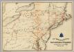
Lines and Metallic Circuit Connections.
1 : 2534400 American Telephone and Telegraph Company
Map of the middle states of North America : shewing the position of the Geneseo country comprehending the counties of Ontario & Steuben as laid off in townships of six miles squar[e] each
1 : 2250000 Maverick, Peter, 1780-1831 Printed by T. & J. Swords, no. 99 Pearl-Street.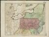
Map of the middle states of America, comprehends New-York, New-Jersey, Pennsylvania, Delaware, and the territory N.W. of Ohio
Russell, John Symonds, Henry Delahoy
New York / drawn by S. Lewis ; Tanner, sc.
from Whole
Northern or Middle States.
1 : 3000000 Cornell, S. S. (Sarah S.)
Middle States.
1 : 3600000 Huntington, Nathaniel G. (Nathaniel Gilbert), 1785-1848
Neu York, Pennsylvanien u. Neu Jersey.
1 : 3400000 Lange, Henry, 1821-1893.
Map of the Middle States.
1 : 3041280 Mitchell, Samuel Augustus
Virginia and Maryland / By H. Moll, geographer.
from Parts
Map of the interior travels through America, delineating the march of the army

Ohio.
1 : 1830000 Carey, Mathew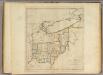
State of Ohio.
1 : 1750000 Carey, Mathew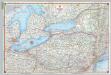
Shell Sectional Map No. 2 - North Atlantic States.
1 : 1457280 Shell Oil Company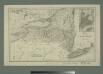
Map of the state of New York with part of Upper Canada / engraved & printed by Fenner Sears & Co.
from Whole
Middle States.
1 : 2800000 Olney, J. (Jesse), 1798-1872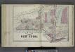
Plan of The State of New York.
from Atlas of Steuben County, New York : from actual surveys and official records / compiled & published by D.G. Beers & Co.
County map of Pennsylvania, New Jersey, Maryland and Delaware ; City of Philadelphia [inset]; City of Baltimore [inset].
from Mitchell's new general atlas, containing maps of the various countries of the world, plans of cities, etc., embraced in fifty-three quarto maps., forming a series of eighty four maps and plans, together with valuable statistical tables.
Railroad & Express Map of the Middle States
1 : 1267200 Railroad & Express Map of the Middle States. R. Blanchard.
Middle & Southern States.
Goodrich, S.G.
A map of the country between Albemarle Sound and Lake Erie : comprehending the whole of Virginia, Maryland, Delaware and Pennsylvania, with parts of several other of the United States of America / engraved by S. J. Neele, No. 352 Strand, London.
from Notes on the state of Virginia; written in the year 1781, somewhat corrected and enlarged in the winter of 1782, for the use of a foreigner of distinction, in answer to certain queries proposed by him ...
Pennsylvania.
1 : 2175000 Schonberg & Co.


