Maps of New York
Shell Sectional Map No. 2 - North Atlantic States.
1 : 1457280 Shell Oil Company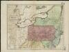
Map of the middle states of America, comprehends New-York, New-Jersey, Pennsylvania, Delaware, and the territory N.W. of Ohio
Russell, John Symonds, Henry Delahoy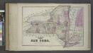
Plan of the State of New York.
from Atlas of Columbia County, New York. From actual surveys and official records. Compiled & published by D. G. Beers & Co.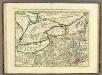
La Pensilvania, la Nuova York, il Jersey Settentriole.
1 : 2100000 Zatta, Antonio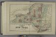
Plan of the State of New York.
from Atlas of Madison County, New York : from actual surveys / by and under the direction of D. G. Beers.
New York, New Jersey, Pennsylvania, and Delaware.
1 : 3652000 Fisher, Richard Swainson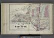
Plan of The State of New York.
from Atlas of Steuben County, New York : from actual surveys and official records / compiled & published by D.G. Beers & Co.
Map of New Jersey and Pennsylvania : exhibiting the post offices, post roads, canals, rail roads, &c. / by David H. Burr (late topographer to the Post Office), geographer to the House of Representatives of the U.S.
from Parts
Neu York, Pennsylvanien u. Neu Jersey.
1 : 3400000 Lange, Henry, 1821-1893.
La Pensilvania, la Nuova York, il Jersey Settentrio[na]le: con la parte occidentale del Connecticut, Massachusset-s-bay e l'Irochesia.
from Parts A. (Antonio) Zatta:[Venezia],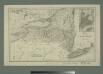
Map of the state of New York with part of Upper Canada / engraved & printed by Fenner Sears & Co.
from Whole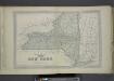
Plan of The State of New York.
from County atlas of Orange, New York / from actual surveys by and under the direction of F.W. Beers.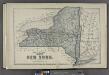
Plan of the State of New York.
from County atlas of Cayuga, New York. From recent and actual surveys and records under the superintendence of F. W. Beers.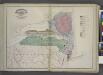
Geological Map
from New topographical atlas and gazetteer of New York, comprising a topographical view of the several counties of the state, ... including ... map of the United States and territories ... Compiled from the latest astronomical observations, official surveys and records of the United States and territories ...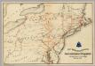
Lines and Metallic Circuit Connections.
1 : 2534400 American Telephone and Telegraph Company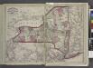
Railroads of the state.
from New topographical atlas and gazetteer of New York, comprising a topographical view of the several counties of the state, ... including ... map of the United States and territories ... Compiled from the latest astronomical observations, official surveys and records of the United States and territories ...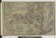
Oswego ; Buffalo ; Rochester ; Syracuse ; New York ; Albany ; Troy ; Vicinity of New York
from Atlas of Montgomery and Fulton counties, New York. From actual surveys / by and under the direction of B. Nichols ; assisted by H.B. Stranahan ... [et al.]
New York / by H.S. Tanner ; engraved ... by H.S. Tanner.
from Whole
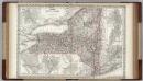
Map of the state of New York : compiled from the latest authorities.
from Whole
Map of the state of New York : compiled from the latest authorities.
from Whole
A map of the province of Pensilvania / drawn from the best authorities, by T. Kitchin, gr.
from John H. Levine Collection
Map of the state of New York : compiled from the latest authorities.
from Whole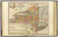
New-York State, surrounding country.
1 : 1300000 Burr, David H., 1803-1875
Map of the State of New York / J.H. Young.
from Whole
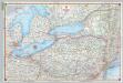
Canada West (Upper).
1 : 1980000 Mitchell, Samuel Augustus
Canada West (Upper).
1 : 1980000 Mitchell, Samuel Augustus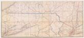
Post route map of the state of New York : and parts of Vermont, Massachusetts, Connecticut, New Jersey and Pennsylvania, showing also the adjacent portions of the dominion of Canada : Southern sheet
1 : 380160 Nicholson, Walter L U.S. Post Office Dept.
Post route map of the state of New York : and parts of Vermont, Massachusetts, Connecticut, New Jersey and Pennsylvania, showing also the adjacent portions of the dominion of Canada : Northern sheet
1 : 380160 Nicholson, Walter L U.S. Post Office Dept.
Map of the state of New York : showing the boundaries of counties & townships, the location of cities, towns and villages, the courses of rail roads, canals & stage roads / by J. Calvin Smith ; engraved on steel by Sherman & Smith.
from Whole