Maps of Allegheny Plat.

A map of the country between Albemarle Sound and Lake Erie : comprehending the whole of Virginia, Maryland, Delaware and Pennsylvania, with parts of several other of the United States of America / engraved by S. J. Neele, No. 352 Strand, London.
from Notes on the state of Virginia; written in the year 1781, somewhat corrected and enlarged in the winter of 1782, for the use of a foreigner of distinction, in answer to certain queries proposed by him ...
Virginia / S. Lewis, del.
from Virginia
Middle States.
1 : 3050000 Smiley, Thomas T.
Virginia, Maryland, and Delaware / J. Knight sc.
from View of the United States, historical, geographical, and statistical, exhibiting, in a convenient form, the natural and artificial features of the several states, and embracing those leading branches of history and statistics best adapted to develop the present condition of the North American union ... By William Darby.
A correct map of Virginia.
from Carey's general atlas, improved and enlarged : being a collection of maps of the world and quarters, their principal empires, kingdoms, &c.
A map of those parts of Virginia, North Carolina, South Carolina & Georgia which were the scenes of the most important operations of the southern armies
from Parts
The State of Virginia from the best authorities, 1796 / B. Tanner sculpt.
from Charts and maps
Virginia, Maryland, and Delaware / by H.S. Tanner.
from Charts and maps
A new chart of the coast of North America : from New York to Cape Hatteras, including the bays of Delaware and Chesapeak, with the coasts of New Jersey, Maryland, Virginia and part of the coast of North Carolina / by Captain N. Holland.
from Parts
Map of the Middle States.
1 : 3041280 Mitchell, Samuel Augustus
The marches of Lord Cornwallis in the Southern Provinces : now States of North America, comprehending the two Carolinas, with Virginia and Maryland, and the Delaware counties / by William Faden, geographer to the King.
from Charts and maps
Soil Map of the United States, Section 8. Atlas of American Agriculture.
1 : 2500000 Marbut, Curtis F.
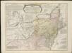
A General Map of the Middle British Colonies, in America.
1 : 2200000 Robert Sayer and John Bennett (Firm)
Virginia.
from Supplement to the New York observer.
The state of Virginia : from the best authorities / by Samuel Lewis, 1809 ; Smither, sculpt.
from Carey's American atlas.
The tourist's pocket map of the state of Virginia : exhibiting its internal improvements, roads, distances, &c. / by J.H. Young ; engraved by E. Yeager & F. Dankworth.
from Virginia
County map of Virginia and West Virginia.
from New general atlas.
The state of Virginia : from the best authorities / by Samuel Lewis, 1794 ; Smither, sculpt.
from Notes on the State of Virginia. By Thomas Jefferson.
Il Maryland, il Jersey Meridionale, la Delaware e la parte orientale della Virginia, e Carolina Settentrionale.
from Le colonie unite dell' America settentrle : di nuova projezione a s.s.e.e. li Signori Riformatori dello Studio di Padova.
County Map Of Virginia, and North Carolina.
1 : 2800000 Mitchell, Samuel Augustus
Il Maryland, il Jersey Meridionale, la Delaware.
1 : 2100000 Zatta, Antonio
Middle States.
1 : 5700000 Grigg, John
Middle States.
1 : 2800000 Huntington, Hezekiah, 1795-1865
Middle States.
1 : 2900000 Mitchell, Samuel Augustus
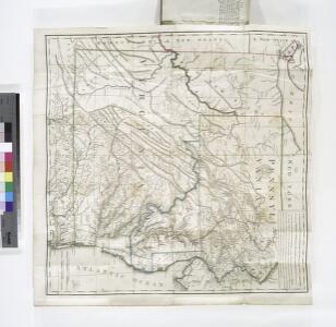
A general map of the middle British colonies, in America, containing Virginia, Maryland, the Delaware counties, Pennsylvania and New Jersey : with the addition of New York, and the greatest part of New England, as also of the bordering parts ...
A general map of the middle British colonies in America, viz. Virginia, Maryland, Delaware, Pensilvania, New-Jersey, New York, Connecticut & Rhode-Island, of Aquanishuonigy the country of the confederate Indians comprehending Aquanishuonigy proper ...

County map of Pennsylvania, New Jersey, Maryland and Delaware ; City of Philadelphia [inset]; City of Baltimore [inset].
from Mitchell's new general atlas, containing maps of the various countries of the world, plans of cities, etc., embraced in fifty-three quarto maps., forming a series of eighty four maps and plans, together with valuable statistical tables.
179. Center manufactures, population 1790-1900.
1 : 3900000 Gannett, Henry, 1846-1914
16. Center of population 1790-1900.
1 : 3900000 Gannett, Henry, 1846-1914