Maps of Spain
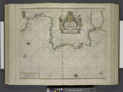
Paskaert van Spanjen, vertoonende de Kusten van Granade, Andaluzie, Algarve, Portugael, Galissen en Biscajen, met een gedeelte van Vranckrijck streckende van Heyssant tot de Straet van Gibralter.
from De zee-atlas ofte water-wereld : waer in vertoont werden alle de zee-kusten van het bekende des aerd-bodems : seer dienstigh voor alle heeren en kooplieden, als oock voor alle schippers en stuurlieden / by Pieter Goos.
Carte des costes de France et d'Espagne
1 Karte : Kupferdruck ; 21 x 26 cm Bellin Arkstée et Merkus
Pas-Caart van Hispaengien vertoonende Custen van Granade, Andaluzie, Algarve Portugael, Galissen, en Biscajen [...] [Karte], in: De Nieuwe Groote Vermeerderde Zee-Atlas ofte Water-Werelt, S. 49.
1 Karte aus Atlas Doncker, Hendrick
Tabula Secunda Europe [Hispania] [Karte], in: Claudii Ptolemei viri Alexandrini mathematice discipline philosophi doctissimi geographie opus [...], S. 154.
1 Karte aus Atlas Waldseemüller, Martin [und Ptolemaeus, Claudius] Übelin, Georg
Tabula Europae II. [Karte], in: Geographia universalis vetus et nova complectens Claudii Ptolemaei Alexandrini enarrationis libros VIII, S. 225.
1 Karte aus Atlas Münster, Sebastian [und Ptolemaeus, Claudius]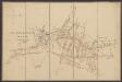
Secunda Europe Tabula [Karte], in: [Clavdii Ptholomei Cosmographi ...], S. 248.
1 Karte aus Atlas Nicolaus Germanus [und Ptolemaeus, Claudius]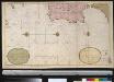
Een gedeelte van de Spaanse Zee van t Canaal tot t Naauw van de Straat
Portugal Gerard van Keulen
The seat of war on the coast of France being a new chart of the coast of Holland, Flanders, France, Spain & Portugal, with the adjacent islands, part of Barbary, England and Ireland
Anglie Bowen, Emanuel T. Jefferys
France.
from A new systeme of the mathematicks: containing I. Arithmetick, as well natural and decimal, as in species, or the principles of algebra. II. Practical geometry, together with the first six books of Euclid's Elements, as also the eleventh and twelfth, symbo
Mapa de España y Portugal: dividido en sus actuales provincias y orlado con los de las posesiones ultramarinas españolas y los planos de las principales ciudades
1 : 800000 . Conté 3 mapes: Islas Canarias, Islas Antillas, Islas Filipinas; i 8 plantes de ciutats: S. Sebastián, Sevilla, La Habana, Madrid, Palma, Zaragoza, Valencia, Barcelona. - Fotografia: T-VI-1-17698 Martín de López, Pedro; Alabern, Ramon Gaspar y Roig
Spanien und Portugal
Schul-Atlas über alle Theile der Erde nach dem neuesten Zustande, und über das Weltgebäude Stieler, Adolf Justus Perthes
Carte generale de toute l'Europe, 4
1 Blatt : 56 x 48 cm J.M. Will
[Jihozápadní Evropa]
1 : 5800000 Evropa jihozápadní
Pas-caart van Hispangien
1 Karte : Kupferdruck ; 43 x 54 cm Doncker; Bree; Bree by Hendrick Doncker boekverkoper en graadbooghmaker in de Nieuwbrugh-steech in 't Stuurmans gereedschap
Pascaart Vande Custen Van Andaluzia, Portugal, Gallißien, Biscajen, en eengedeelt von Vranckryck [...] [Karte], in: Het vijfde Deel Des Grooten Atlas : Vervatende De Water-Weereld, S. 175.
1 Karte aus Atlas Jansson, Jan Jansson, Jan
Pascaart Vande Custen Van Andaluzia, Portugal Gallißien, Biscajen, en een gedeelte van Vranckryck [...] [Karte], in: Novus atlas absolutissimus, Bd. 9, S. 232.
1 Karte aus Atlas Janssonius Offizin
[XVI], uit: Geognostische Karte des Oesterreichischen Kaiserstaates mit einem grossen Theile Deutschland's u. Italien / hauptsachlich nach ... Haidinger's geognostischer Karte dieses Staates bearb. von Josef Scheda
1 : 3000000 titelvariant: General-Karte von Europa in 25 Blättern; Annotatie: Bijlage bij: General-Karte von Europa in 25 Blättern. - 1:2.592.000. - 1845-1847 Scheda, Joseph Wien : K.K. Militär. Geografisch. Institut
Regnorum Hispaniae nova descriptio
1 mapa, col.. Text: francès. Reclam: A, 1. - Originàriament dins: Le Theatre du monde ou novvel atlas, mis en lumiere par Gvillavme & Iean Blaeu. Amsterdam, 1643. Blaeu, Willem Jansz.; Blaeu, Joan mis en lumiere par Gvillavme & Iean Blaeu
France, Spain, and Portugal.
1 : 3650000 Johnson, A.J.
France, Spain, and Portugal.
1 : 3650000 Johnson, A.J.
Spanien und Portugal
E. von Sydow's Schul-Atlas in sechs und dreissig Karten Sydow, Emil von bei Justus Perthes
Tabula Moderna Et Nova Hispanie [Karte], in: Claudii Ptolemei viri Alexandrini mathematice discipline philosophi doctissimi geographie opus [...], S. 239.
1 Karte aus Atlas Waldseemüller, Martin [und Ptolemaeus, Claudius] Übelin, Georg
Spain, Portugal, W. France.
1 : 3000000 Philip, George
Carte générale de l'Espagne et du Portugal / par A.H. Brué
1 Mapa. Atlas universel; 22 Brué. Adrien-Hubert chez l'auteur et chez Simonneau
France, Spain, and Portugal.
1 : 3658000 Johnson, A.J.
[Spanien und Portugal, Iberische Halbinsel]
Geographischer Atlas über alle Theile der Erde Ziegler, Jakob Melchior Verlag von Dietrich Reimer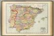
Spain, Portugal.
1 : 1930000 Rand McNally and Company
Hispaniae Veteris Descriptio. [Karte], in: Theatrum orbis terrarum, S. 459.
1 Karte aus Atlas Ortelius, Abraham Vrients, Jan Baptista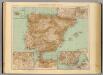
37-38. Spagna, Portogallo.
1 : 3000000 Touring club italiano