Maps of Spain

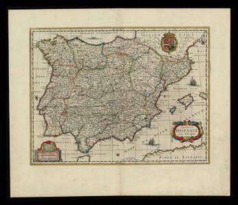
Regnorum Hispaniae nova descriptio
1 mapa, col.. Text: francès. Reclam: A, 1. - Originàriament dins: Le Theatre du monde ou novvel atlas, mis en lumiere par Gvillavme & Iean Blaeu. Amsterdam, 1643. Blaeu, Willem Jansz.; Blaeu, Joan mis en lumiere par Gvillavme & Iean Blaeu
Spanien und Portugal
Schul-Atlas über alle Theile der Erde nach dem neuesten Zustande, und über das Weltgebäude Stieler, Adolf Justus Perthes
Spanien und Portugal
E. von Sydow's Schul-Atlas in sechs und dreissig Karten Sydow, Emil von bei Justus Perthes
Mapa de España y Portugal: dividido en sus actuales provincias y orlado con los de las posesiones ultramarinas españolas y los planos de las principales ciudades
1 : 800000 . Conté 3 mapes: Islas Canarias, Islas Antillas, Islas Filipinas; i 8 plantes de ciutats: S. Sebastián, Sevilla, La Habana, Madrid, Palma, Zaragoza, Valencia, Barcelona. - Fotografia: T-VI-1-17698 Martín de López, Pedro; Alabern, Ramon Gaspar y Roig
Carte générale de l'Espagne et du Portugal / par A.H. Brué
1 Mapa. Atlas universel; 22 Brué. Adrien-Hubert chez l'auteur et chez Simonneau
Hispaniae Veteris Descriptio. [Karte], in: Theatrum orbis terrarum, S. 459.
1 Karte aus Atlas Ortelius, Abraham Vrients, Jan Baptista
[Spanien und Portugal, Iberische Halbinsel]
Geographischer Atlas über alle Theile der Erde Ziegler, Jakob Melchior Verlag von Dietrich Reimer
Spain and Portugal
Gent. Mag.
Hispania III. Nova Tabula [Karte], in: Claud. Ptolemaeus. Geographia lat. cum mappis [...], S. 338.
1 Karte aus Atlas Münster, Sebastian [und Ptolemaeus, Claudius]
Hispaniae Veteris Descriptio. [Karte] [Blastophoenices, Region Cádiz] [Nebenkarte], in: Theatrum orbis terrarum, S. 368.
1 Karte aus Atlas Ortelius, Abraham
Hispania III. Nova Tabula [Karte], in: Geographia universalis vetus et nova complectens Claudii Ptolemaei Alexandrini enarrationis libros VIII, S. 308.
1 Karte aus Atlas Münster, Sebastian [und Ptolemaeus, Claudius]
Tabula Moderna Hispanie [Karte], in: [Clavdii Ptholomei Cosmographi ...], S. 251.
1 Karte aus Atlas Nicolaus Germanus [und Ptolemaeus, Claudius]
Mare Mediterraneum, 1
1 Blatt : 47 x 58 cm G. und L. Valck
37-38. Spagna, Portogallo.
1 : 3000000 Touring club italiano
Secunda Europe Tabula [Karte], in: [Clavdii Ptholomei Cosmographi ...], S. 248.
1 Karte aus Atlas Nicolaus Germanus [und Ptolemaeus, Claudius]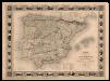
Carte administrative, physique et routiere de l'Espagne et du Portugal indiquant les canaux, les rivieres naviables, les routes de poste et les nouvelles divisions des provinces, &c.
1 Mapa, col. Orla amb 32 vistes de ciutats i monuments. - Limits acolorits Dufour, A.-H. Dufour, Bulla et Jouy
Hispaniae Veteris Descriptio.[Karte] [Iulia Gaditana Aug. und Umgebung] [Nebenkarte], in: Gerardi Mercatoris et I. Hondii Newer Atlas, oder, Grosses Weltbuch, Bd. 2, S. 207.
1 Karte aus Atlas Mercator, Gerhard und Hondius, Jodocus Jansson, Jan
L'Espagne divisée en tous ses Royaumes Et Principautés [...] [Karte], in: Atlas nouveau, contenant toutes les parties du monde [...], Bd. 2, S. 107.
1 Karte aus Atlas Sanson, Nicolas Jaillot, Alexis Hubert und Mortier, Pieter
France.
from A new systeme of the mathematicks: containing I. Arithmetick, as well natural and decimal, as in species, or the principles of algebra. II. Practical geometry, together with the first six books of Euclid's Elements, as also the eleventh and twelfth, symbo
Hispaniae Veteris Descriptio. [Karte] [Iulia Gaditana Aug. und Umgebung] [Nebenkarte], in: Novus atlas absolutissimus, Bd. 6, S. 8.
1 Karte aus Atlas Janssonius Offizin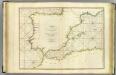
Coasts Spain, Portugal, Barbary.
1 : 3200000 Faden, William, 1750?-1836
Emirat von Cordoba bis zum Untergange der Ommijaden; christlichen Reiche im Norden der iberischen Halbinsel 711 bis 1028.
1 : 3700000 Spruner von Merz, Karl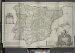
A new & exact map of Spain and Portugal, divided into its kingdoms and principalities &c. ...
from The world described, or, A new and correct sett of maps : shewing the kingdoms and states in all the known parts of the earth, with the principal cities, and most considerable towns in the world ... / ... by Herman Moll, geographer ...
Tabula Moderna Et Nova Hispanie [Karte], in: Claudii Ptolemei viri Alexandrini mathematice discipline philosophi doctissimi geographie opus [...], S. 239.
1 Karte aus Atlas Waldseemüller, Martin [und Ptolemaeus, Claudius] Übelin, Georg
L'Espagne
1 Karte : Kupferdruck ; 47 x 59 cm L'Isle; Luchtenburg; Silva chez I. Covens et C. Mortier
Die iberische Halbinsel bis in die Mitte des XIIIten Jahrhundert's.
1 : 3800000 Spruner von Merz, Karl
Die iberische Halbinsel seit dem Anfange des XVIten. Jahrhundert's (1479).
1 : 3800000 Spruner von Merz, Karl
Regnorum Hispaniæ et Portugalliæ tabula generalis de l'Isliana
1 Karte : Kupferdruck ; 46 x 58 cm Homann; L'Isle Johann Baptist Homann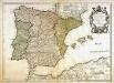
L'Espagne
1 Karte : Kupferdruck ; 44 x 61 cm L'Isle; Berey; Silva; Simonneau chez l'auteur sur le quai de l'horloge