Maps of Portugal
Een gedeelte van de Spaanse Zee van t Canaal tot t Naauw van de Straat
Portugal Gerard van Keulen
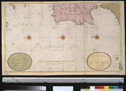
Paskaert van Spanjen, vertoonende de Kusten van Granade, Andaluzie, Algarve, Portugael, Galissen en Biscajen, met een gedeelte van Vranckrijck streckende van Heyssant tot de Straet van Gibralter.
from De zee-atlas ofte water-wereld : waer in vertoont werden alle de zee-kusten van het bekende des aerd-bodems : seer dienstigh voor alle heeren en kooplieden, als oock voor alle schippers en stuurlieden / by Pieter Goos.
Pas-Caart van Hispaengien vertoonende Custen van Granade, Andaluzie, Algarve Portugael, Galissen, en Biscajen [...] [Karte], in: De Nieuwe Groote Vermeerderde Zee-Atlas ofte Water-Werelt, S. 49.
1 Karte aus Atlas Doncker, Hendrick
[XVI], uit: Geognostische Karte des Oesterreichischen Kaiserstaates mit einem grossen Theile Deutschland's u. Italien / hauptsachlich nach ... Haidinger's geognostischer Karte dieses Staates bearb. von Josef Scheda
1 : 3000000 titelvariant: General-Karte von Europa in 25 Blättern; Annotatie: Bijlage bij: General-Karte von Europa in 25 Blättern. - 1:2.592.000. - 1845-1847 Scheda, Joseph Wien : K.K. Militär. Geografisch. Institut
Pas-caart van Hispangien
1 Karte : Kupferdruck ; 43 x 54 cm Doncker; Bree; Bree by Hendrick Doncker boekverkoper en graadbooghmaker in de Nieuwbrugh-steech in 't Stuurmans gereedschap
Pascaart Vande Custen Van Andaluzia, Portugal, Gallißien, Biscajen, en eengedeelt von Vranckryck [...] [Karte], in: Het vijfde Deel Des Grooten Atlas : Vervatende De Water-Weereld, S. 175.
1 Karte aus Atlas Jansson, Jan Jansson, Jan
Pascaart Vande Custen Van Andaluzia, Portugal Gallißien, Biscajen, en een gedeelte van Vranckryck [...] [Karte], in: Novus atlas absolutissimus, Bd. 9, S. 232.
1 Karte aus Atlas Janssonius Offizin
Feuille 29 (A V), uit: Carte géologique internationale de l'Europe : la carte, votée au congrès géologique international de Bologne en 1881, est exécutée conformément aux décisions d'une commission internationale, avec le concours des gouvernements, sous le dir. de M.M. Beyrich et Hauchecorne
Annotatie: Blad 48 gamme des couleurs; blad 49: bladwijzer en titelblad Heinrich Ernst Beyrich 1815-1896; Wi. Hauchecorne Berlin : Reimer / (Berlin: Institut lithographique)
Neueste Karte von Portugal
Grosser Hand-Atlas über alle Theile der Erde in 170 Karten Meyer, J. Verlag des Bibliographischen Instituts
Carte réduite des costes d'Espagne et de Portugal
1 Karte : Kupferdruck ; 87 x 54 cm Bellin s.n.
Spain & Portugal - western section.
1 : 2000000 John Bartholomew and Son

Pas caert van 't in komen van de Canael
1 Karte : Kupferdruck ; 42 x 53 cm Doncker bÿ Hendrick Doncker boeckverkoper inde Nieuwbrugh steegh in 't Stuurmans gereetschap
Hispaniæ, et Portugalliæ maritimi tractus, à S. Andero, ad Malagam
1 Karte : Kupferdruck ; 47 x 56 cm Renard Louis Renard
[132][135] Hispaniae, et Portugalliae Maritimi tractus, uit: Atlas sive Descriptio terrarum orbis
Annotatie: Gedigitaliseerde versie. Amsterdam. Heiloo : Picturae (vervaardiger), 2015. tiff-bestand. Gedigitaliseerd: 07-01-2015; Origineel: Universiteitsbibliotheek Vrije Universiteit (XL.05127.-) ; Netherlands; Titelpagina ontbreekt Wit, Frederik de Amsterdam : Frederick de Wit
Feuille 22 (A IV), uit: Carte géologique internationale de l'Europe : la carte, votée au congrès géologique international de Bologne en 1881, est exécutée conformément aux décisions d'une commission internationale, avec le concours des gouvernements, sous le dir. de M.M. Beyrich et Hauchecorne
Annotatie: Blad 48 gamme des couleurs; blad 49: bladwijzer en titelblad Heinrich Ernst Beyrich 1815-1896; Wi. Hauchecorne Berlin : Reimer / (Berlin: Institut lithographique)
Carte de la Peninsule Hispanique.
1 : 2750000 Vivien de St Martin, L.
Feuille 36 (A VI), uit: Carte géologique internationale de l'Europe : la carte, votée au congrès géologique international de Bologne en 1881, est exécutée conformément aux décisions d'une commission internationale, avec le concours des gouvernements, sous le dir. de M.M. Beyrich et Hauchecorne
Annotatie: Blad 48 gamme des couleurs; blad 49: bladwijzer en titelblad Heinrich Ernst Beyrich 1815-1896; Wi. Hauchecorne Berlin : Reimer / (Berlin: Institut lithographique)
Portugall.
from A new systeme of the mathematicks: containing I. Arithmetick, as well natural and decimal, as in species, or the principles of algebra. II. Practical geometry, together with the first six books of Euclid's Elements, as also the eleventh and twelfth, symbo
The coasts of PORTUGALL and part of SPAIN from cape finifterre to Gibralter
from The sea-atlas : containing an hydrographical description of most of the sea-coasts of the known parts of the world.
Portugalliæ et Algarbiæ regna
1 Karte : Kupferdruck ; 48 x 56 cm Seutter Matthäus Seutter
Portugalliæ et Algarbiæ cum finitimis Hispanniæ regnis
1 Karte : Kupferdruck ; 48 x 54 cm Homann Johann Baptist Homann
Portugalliae et Algarbiae Regna / per Nicolaum Visscher
1 : 1500000 Annotatie: Cum privilegio ordinum Hollandiæ et West-Frisiæ; Origineel is Blad 6 in atlas factice; Annotatie geografische gegevens: Met 3 schaalstokken; Legenda Nicolaes Jansz. Visscher jr. 1649-1702 [Amsterdam : Nicolaes Visscher]
Portugalliae et Algarbiae Regna
1 : 1500000 per Nicolaum Visscher [Amsterdam] : nunc apud Petrum Schenk Junior
Regna Portugalliæ et Algarbiæ
1 Karte : Kupferdruck ; 56 x 47 cm Lotter; Lotter Tobias Konrad Lotter
Portugallia et Algarbia quae olim Lusitania. [Karte], in: Le théâtre du monde, ou, Nouvel atlas contenant les chartes et descriptions de tous les païs de la terre, Bd. 2, S. 219.
1 Karte aus Atlas Blaeu, Willem Janszoon und Blaeu, Joan Blaeu, Willem Janszoon
Portugalliæ et Algarbiæ regna
1 Karte : Kupferdruck ; 45 x 55 cm Visscher Nicolaes Visscher
Les estats de la couronne de Portugal en Espagne
1 Karte : Kupferdruck ; 41 x 43 cm Sanson; Somer chez l'autheur
Portugallia et Algarbia quae olim Lusitania. [Karte], in: Novus Atlas, das ist, Weltbeschreibung, Bd. 2, S. 228.
1 Karte aus Atlas Blaeu, Joan Blaeu, Willem Janszoon