Maps of Belarus

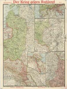
Paasche's Frontenkarte, Nr.12. Der Krieg gegen Russland

Ostmitteleuropa 1795
Ostmitteleuropa Kunz, Andreas ; Treiling, Thomas
Lithuania. [Karte], in: Gerardi Mercatoris Atlas, sive, Cosmographicae meditationes de fabrica mundi et fabricati figura, S. 161.
1 Karte aus Atlas Mercator, Gerhard Montanus, Petrus
Lithuania. [Karte], in: Atlas, sive, Cosmographicae meditationes de fabrica mundi et fabricati figura, S. 156.
1 Karte aus Atlas Mercator, Gerhard
Magni dvcatvs Lithvaniae, et regionum adiacentium exacta descriptio
1 : 2000000 Bělorusko Blaeu, Joan I. Blaeu
Westliches Russland
1 : 2000000 Evropa východní Handtke, Friedrich Carl Flemming
Estats de la couronne de Pologne
1 : 2800000 Evropa východní Jaillot, Alexis-Hubert H. Jaillot
ESTATS DE LA COURONNE DE POLOGNE
1 : 2800000 Evropa východní Jaillot, Alexis-Hubert H. Jaillot
Západní Rusko a přilehlé části říše Německé a Rakousko-Uherska
1 : 1250000 Německo východní Machát, František V. Neubert
Poland, Prussia, and Hungary.
1 : 5000000 Lavoisne, M.
Neueste karte von Polen und Lithauen nebst Theilen der angränzenden Länder
Litva C. Hoffmann

(La Pologne)
1 : 13000000 Bruyset, Jean-Marie; Schneider, J. H.
Mapa Polski
1 : 1500000 Evropa střední a východní Pokorny, Wilhelm Tomaszewski, Adam Księgarnia polska Bernarda Połonieckiego
Paasche's Frontenkarte, Nr.4. Der Krieg gegen Russland

Paasche's Frontenkarte, Nr.4. Der Krieg gegen Russland

Dritte Theilung Polens 1795
Polen Teilung Polens <1795>
MAGNI DVCATVS | LITHVANIÆ | et Regionum Adiacentium
exacta Descriptio | Ill.mi ac Excell.mi Principis et Dni. D. Nicolai Christophori Radziwil... opera, cura et impensis olim facta, ac nunc denuo hac forma edita a I. Blaeu. Ioannes Blaeu | Excudebat.
Paasche's Frontenkarte, Nr.6. Der Krieg gegen Russland

Dritte Theilung Polens 1795
Polen Teilung Polens <1795>
Poland: Natural increase
1 : 3000000 Series of maps on various aspects of Poland. Natural increase. Annual increase of population. War Office
Nyugat – Oroszország

Nova descriptio regni Poloniae et magni ducatus Lithuaniae
1 : 6600000 Litva
Magni Dvcatvs Lithvaniae caeterarum. regionum illi adiacentium exacta descrip
1 : 2800000 Bělorusko Janssonius, Johannes sumptibus Ioannis Ianßonii
Magni dvcatvs Lithvaniae caeterarumqve regionum illi adiacentivm exacta descriptio
1 : 1300000 Litva Hessel, Gerard excudebat Guilhelmus Ianßonius
Erste Theilung Polens 1772
Polen Teilung Polens <1772>
Polens Umwandelungen von 1772-1809
1 : 2100000 Polsko zu finden in der Dykischen Buchhandlung
Charte von Polen
1 : 2300000 Bělorusko Kipferling, Karl Joseph Artaria
Zweite Theilung Polens 1793
Polen Teilung Polens <1793>