Maps of Veleslavín

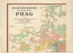
Orientační plán hlavního města Prahy s okolím

Orientační plán hlavního města Prahy s okolím
1 : 5000
Výškopisný plán hlavního města Prahy s okolím

Welleslawin - c8362-1-002 - Kaiserpflichtexemplar der Landkarten des stabilen Katasters
1 : 2880
Welleslawin - c8362-1-001 - Kaiserpflichtexemplar der Landkarten des stabilen Katasters
1 : 2880
Plan von den Wilden Scharka und Hlubotsch bey Prag
Liboc (Praha, Česko) Bittner, Joseph
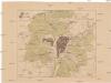
Gross Brzewnow (Welky Břewnow) - c0558-1-001 - Kaiserpflichtexemplar der Landkarten des stabilen Katasters
1 : 2880
Gross Brzewnow (Welky Břewnow) - c0558-1-002 - Kaiserpflichtexemplar der Landkarten des stabilen Katasters
1 : 2880
Gross Brzewnow (Welky Břewnow) - c0558-1-003 - Kaiserpflichtexemplar der Landkarten des stabilen Katasters
1 : 2880
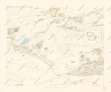
Orientační plán Prahy a obcí sousedních List 9a.
1 : 5000
Wokowitz (Wokowice) - c8748-1-001 - Kaiserpflichtexemplar der Landkarten des stabilen Katasters
1 : 2880
Wokowitz (Wokowice) - c8748-1-002 - Kaiserpflichtexemplar der Landkarten des stabilen Katasters
1 : 2880
Wokowitz (Wokowice) - c8748-1-003 - Kaiserpflichtexemplar der Landkarten des stabilen Katasters
1 : 2880
Plan der Gegend vor dem Strahofer Thor der Hauptstadt Prag
Strahov (Praha, Česko) Thurn-Taxis, Wilhelm von Renner, Emanuel von
Orientační plán hlavního města Prahy
Orientierungsplan der Hauptstadt Prag
Jiřík, Rudolf
Grundris der kaisel. königl. Hauptstadt Prag im Königreich Böhmen
Praha (Česko) Scheidlen, CH. F. Seybold, I.
Libotz (Liboc) - c1327-1-002 - Kaiserpflichtexemplar der Landkarten des stabilen Katasters
1 : 2880
Libotz (Liboc) - c1327-1-001 - Kaiserpflichtexemplar der Landkarten des stabilen Katasters
1 : 2880
Libotz (Liboc) - c1327-1-003 - Kaiserpflichtexemplar der Landkarten des stabilen Katasters
1 : 2880
Auto-Praha : automobilní plán Velké Prahy a příručka pro automobilisty
1 : 50000
Situations-Plan der königl. Hauptstadt Prag nebst Smichov u. Karolinenthal
1 : 4000 Karlín (Praha, Česko) Mayr, Josef Spolek notářů v Čechách
Plán voj. cvičiště v Motole
1 : 10000 Motol (Praha, Česko) Vojenský zeměpisný ústav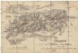
Croquis zur schriftlichen Ausarbeitung
1 : 13500 Bílá Hora (Praha, Česko)
Kriegs-Expedit. Karte in Böhmen III Blat in welcher die Belagerung Prag A. 1742 von den 28. Iul. bis 13. 7br. zuversichtlich vorgestellet wird
Malá Strana (Praha, Česko) Sinsart Perizot von Homaenn. Erben
Orientační plán Prahy a obcí sousedních List 14.

Orientační plán král. Hl. města Prahy
Okolí pražské
Praha (Česko) Hurtig, Alfred Seybold, I.
Plan der Stadt Prag mit denen umliegenden Gegenden wie es von der preussischen Armée unter comando des Königs von Preussen und des Feld Mareschal Keith von den 8 May biss den 19 Juny 1757 ist belagert worden
1 : 168000 Praha (Česko) Prasser, Baptist bey Herrn Baptist Prasser