Maps of Dejvice
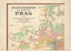
Orientierungsplan der Hauptstadt Prag
Jiřík, Rudolf
Orientační plán hlavního města Prahy
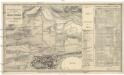
Situations-Plan der Gegend vor dem Carls-Thore zum Gebrauche bei der Beurtheilung der Distanzen
1 : 26000 Praha (Česko) Situations-Zeichnungs-Schule des k. k. G.F.M.L. Graf Künigl 1. Feld-Artilerie-Regiments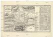
Situations-Plan der Gegend vor dem Carls-Thore zum Gebrauche bei der Beurtheilung der Distanzen
1 : 26000 Praha (Česko) Situations-Zeichnungs-Schule des k. k. G.F.M.L. Graf Künigl 1. Feld-Artilerie-Regiments
Nebuschitz (Nebussic) - c4983-1-001 - Kaiserpflichtexemplar der Landkarten des stabilen Katasters
1 : 2880
Nebuschitz (Nebussic) - c4983-1-002 - Kaiserpflichtexemplar der Landkarten des stabilen Katasters
1 : 2880
Nebuschitz (Nebussic) - c4983-1-003 - Kaiserpflichtexemplar der Landkarten des stabilen Katasters
1 : 2880
Nebuschitz (Nebussic) - c4983-1-004 - Kaiserpflichtexemplar der Landkarten des stabilen Katasters
1 : 2880
Nebuschitz (Nebussic) - c4983-1-005 - Kaiserpflichtexemplar der Landkarten des stabilen Katasters
1 : 2880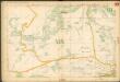
Auto-Praha : automobilní plán Velké Prahy a příručka pro automobilisty
1 : 50000
Libotz (Liboc) - c1327-1-002 - Kaiserpflichtexemplar der Landkarten des stabilen Katasters
1 : 2880
Libotz (Liboc) - c1327-1-001 - Kaiserpflichtexemplar der Landkarten des stabilen Katasters
1 : 2880
Libotz (Liboc) - c1327-1-003 - Kaiserpflichtexemplar der Landkarten des stabilen Katasters
1 : 2880
Horoměřitz (Horoměřic) - c2184-1-003 - Kaiserpflichtexemplar der Landkarten des stabilen Katasters
1 : 2880
Horoměřitz (Horoměřic) - c2184-1-001 - Kaiserpflichtexemplar der Landkarten des stabilen Katasters
1 : 2880
Horoměřitz (Horoměřic) - c2184-1-002 - Kaiserpflichtexemplar der Landkarten des stabilen Katasters
1 : 2880
Horoměřitz (Horoměřic) - c2184-1-004 - Kaiserpflichtexemplar der Landkarten des stabilen Katasters
1 : 2880
Degwitz (Degwic) - c1085-1-001 - Kaiserpflichtexemplar der Landkarten des stabilen Katasters
1 : 2880
Degwitz (Degwic) - c1085-1-002 - Kaiserpflichtexemplar der Landkarten des stabilen Katasters
1 : 2880
Degwitz (Degwic) - c1085-1-003 - Kaiserpflichtexemplar der Landkarten des stabilen Katasters
1 : 2880
Degwitz (Degwic) - c1085-1-004 - Kaiserpflichtexemplar der Landkarten des stabilen Katasters
1 : 2880
Plan von den Wilden Scharka und Hlubotsch bey Prag
Liboc (Praha, Česko) Bittner, Joseph
Orientační plán Prahy a obcí sousedních List 9a.
1 : 5000
Monumentální plán královského města Prahy

Mapový obraz Malé Strany a Strahova ze 17. století : [faksimile plánů]

Wokowitz (Wokowice) - c8748-1-001 - Kaiserpflichtexemplar der Landkarten des stabilen Katasters
1 : 2880
Wokowitz (Wokowice) - c8748-1-002 - Kaiserpflichtexemplar der Landkarten des stabilen Katasters
1 : 2880
Wokowitz (Wokowice) - c8748-1-003 - Kaiserpflichtexemplar der Landkarten des stabilen Katasters
1 : 2880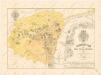
Polohopisný plán Malé Strany a Hradčan


