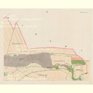
Maps of Nebušice

Nebuschitz (Nebussic) - c4983-1-001 - Kaiserpflichtexemplar der Landkarten des stabilen Katasters
1 : 2880
Nebuschitz (Nebussic) - c4983-1-002 - Kaiserpflichtexemplar der Landkarten des stabilen Katasters
1 : 2880
Nebuschitz (Nebussic) - c4983-1-003 - Kaiserpflichtexemplar der Landkarten des stabilen Katasters
1 : 2880
Nebuschitz (Nebussic) - c4983-1-004 - Kaiserpflichtexemplar der Landkarten des stabilen Katasters
1 : 2880
Nebuschitz (Nebussic) - c4983-1-005 - Kaiserpflichtexemplar der Landkarten des stabilen Katasters
1 : 2880
Výškopisný plán hlavního města Prahy s okolím

Orientační plán hlavního města Prahy s okolím

Orientační plán hlavního města Prahy s okolím

Orientační plán Prahy a obcí sousedních List 3a.

Orientační plán hlavního města Prahy s okolím

Orientační plán Prahy a obcí sousedních List 3a.
1 : 5000
Orientační plán hlavního města Prahy s okolím
1 : 5000
Orientační plán hlavního města Prahy s okolím
1 : 5000
Vorder Kopanina (Přednj Kopanina) - c6177-1-003 - Kaiserpflichtexemplar der Landkarten des stabilen Katasters
1 : 2880
Vorder Kopanina (Přednj Kopanina) - c6177-1-002 - Kaiserpflichtexemplar der Landkarten des stabilen Katasters
1 : 2880
Vorder Kopanina (Přednj Kopanina) - c6177-1-001 - Kaiserpflichtexemplar der Landkarten des stabilen Katasters
1 : 2880
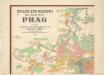
Auto-Praha : automobilní plán Velké Prahy a příručka pro automobilisty
1 : 50000
Wokowitz (Wokowice) - c8748-1-001 - Kaiserpflichtexemplar der Landkarten des stabilen Katasters
1 : 2880
Wokowitz (Wokowice) - c8748-1-002 - Kaiserpflichtexemplar der Landkarten des stabilen Katasters
1 : 2880
Wokowitz (Wokowice) - c8748-1-003 - Kaiserpflichtexemplar der Landkarten des stabilen Katasters
1 : 2880
Horoměřitz (Horoměřic) - c2184-1-003 - Kaiserpflichtexemplar der Landkarten des stabilen Katasters
1 : 2880
Horoměřitz (Horoměřic) - c2184-1-001 - Kaiserpflichtexemplar der Landkarten des stabilen Katasters
1 : 2880
Horoměřitz (Horoměřic) - c2184-1-002 - Kaiserpflichtexemplar der Landkarten des stabilen Katasters
1 : 2880
Horoměřitz (Horoměřic) - c2184-1-004 - Kaiserpflichtexemplar der Landkarten des stabilen Katasters
1 : 2880
Orientační plán král. Hl. města Prahy

Orientační plán Prahy a obcí sousedních List 3.
1 : 5000
Orientační plán Prahy a obcí sousedních List 9a.
1 : 5000
Orientační plán hlavního města Prahy
Orientierungsplan der Hauptstadt Prag
Jiřík, Rudolf