Maps of Argyll and Bute

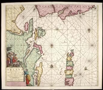
Pascaart van de noortcust van Yrland als meede de westcust van Schotland / by Johannes van Keulen.
Keulen, Johannes van, 1654-1715
De West kust van Schot Landt de Noord kust van IJrland en de Lewijs Eijlanden na een Engels caertie gelegt
Scotland Gerard van Keulen
De West cust van Schotlandt, de Noord cust Irlandt en de Lewijs Eijlanden int groodt met al de bijleggende eijlanden
Scotland Gerard van Keulen
ÆBUDÆ INSULÆ | Sive | HEBRIDES; | Quæ Scotiæ ad occasum prætenduntur, [...] THE WESTERNE ILES | OF SCOTLAND.
lustratæ et descriptæ a | Timotheo Pont. [Amsterdam : Joan Blaeu]
A general chart of the west coast and western islands of Scotland from Cantire to Cape Wrath and Butt of the Lewis.
Mackenzie, Murdoch (Senior), 1712-1797 Terry, G.
To the Honorable Sr. Charles Wager, this Draught of Part of the Highlands of Scotland / is humblely Presented by... Mark Tiddeman.
Tiddeman, Mark, fl. ca. 1730
Scotland SW.
1 : 486830 Stanford, Edward
Nieuwe afteekening van de West kust van Schotlant en de Lewijs Eijlanden met alle de tussen leggende eijlanden
Scotland Gerard van Keulen
A general map of Scotland and islands thereto belonging, 3
2 Blätter : 91 x 76 cm s.n.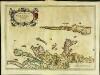
Æbudæ insulæ sive Hebrides
1 Karte : Kupferdruck ; 37 x 52 cm Blaeu; Pont Joan Blaeu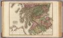
Scotland, southern part.
1 : 518000 Pinkerton, John, 1758-1826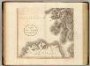
Scotland SW.
1 : 500000 Cary, John, ca. 1754-1835
Carte particuliere de la cote occidentale d'Escosse, depuis la Pointe d'Ardnamurchan jusqu'au Mull de Galloway.
Depot Generale de la Marine, Paris
Lochabria, omnesque Insulae versus Occidentem sitae, ut Uisto, Mulla, aliaeque. [Karte], in: Novus atlas absolutissimus, Bd. 8, S. 172.
1 Karte aus Atlas Janssonius Offizin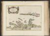
Aebudae Insulae sive Hebrides ; quae Scotiae ad occasum praetenduntur / lustratae et descriptae a Timotheo Pont. Western Isles of Scotland.
Pont, Timothy, 1560?-1614? Blaeu, Joan, 1596-1673
Lorna, Knapdalia, Cantire, Iura, Ila, Glota, et Buthe Insulae. [Karte], in: Novus atlas absolutissimus, Bd. 8, S. 175.
1 Karte aus Atlas Janssonius Offizin
Lochabria, omnesq[ue] insulæ versus occidentem sitæ, ut Visto, Mulla, aliæque
1 Karte : Kupferdruck ; 42 x 51 cm Valck; Schenk sumptibus Gerardi Valk et Petri Schenk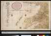
Nieuwe afteekening van de West kust van SchotLandt als mede een gedeelte van de Lewijs Eijlanden en Skie, Mulla, Tijrrif, Col int groot
Scotland Gerard van Keulen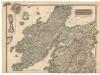
Northern Part of Argyll Shire.
Thomson, John, 1777- ca. 1840 Johnson, William, fl. 1806-1840
Southern Part of Argyll Shire.
Thomson, John, 1777- ca. 1840 Johnson, William, fl. 1806-1840
A map of such part of his Grace the Duke of Argyle's heritable dukedom, and justiciary territories, islands, superiorities & jurisdictions as lye contiguous upon the western Coast of North Britain
Cowley, J. (John)
Nieuwe Caart van de Rivier van Glasgow in 't Groot.
Keulen, Johannes van, 1654-1715
Composite: Argyllshire.
1 : 175000 Thomson, John
Ordnance Survey of Great Britain, Scotland
Ordnance Survey
Map of St Kilda or Hirta and adjacent islands...
Mathieson, John
St Kilda.
Stevenson, Robert, 1772-1850
delineation of the strata of England and Wales, with part of Scotland
1 : 320000 Blatt 1 Smith, William Cary
A Map of the North West part of the Western Islands / by H. Moll.
Moll, Herman, d. 1732
A new chart of the West coast of Scotland from the Mull of Galloway to Dunan Point in Sky.
Huddart, Joseph, 1740/1-1816 Laurie, Robert Whittle, James
Carte particuliere de la cote occidentale d'Escosse, depuis le Cape Wrath jusqu'a la Pointe d'Ardnamurchan.
Depot Generale de la Marine, Paris