Maps of Argyll and Bute

Scotland SW.
1 : 486830 Stanford, Edward
A general map of Scotland and islands thereto belonging, 3
2 Blätter : 91 x 76 cm s.n.
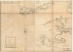
Pascaart van de noortcust van Yrland als meede de westcust van Schotland / by Johannes van Keulen.
Keulen, Johannes van, 1654-1715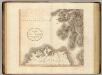
Scotland SW.
1 : 500000 Cary, John, ca. 1754-1835
Carte particuliere de la cote occidentale d'Escosse, depuis la Pointe d'Ardnamurchan jusqu'au Mull de Galloway.
Depot Generale de la Marine, Paris
Lorna, Knapdalia, Cantire, Iura, Ila, Glota, et Buthe Insulae. [Karte], in: Novus atlas absolutissimus, Bd. 8, S. 175.
1 Karte aus Atlas Janssonius Offizin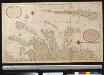
Nieuwe afteekening van de West kust van Schotlant en de Lewijs Eijlanden met alle de tussen leggende eijlanden
Scotland Gerard van Keulen
A map of such part of his Grace the Duke of Argyle's heritable dukedom, and justiciary territories, islands, superiorities & jurisdictions as lye contiguous upon the western Coast of North Britain
Cowley, J. (John)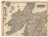
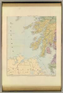
Northern Part of Argyll Shire.
Thomson, John, 1777- ca. 1840 Johnson, William, fl. 1806-1840
Southern Part of Argyll Shire.
Thomson, John, 1777- ca. 1840 Johnson, William, fl. 1806-1840
Composite: Argyllshire.
1 : 175000 Thomson, John
Scotland / J. Ainslie, 7
1 Blatt : 67 x 58 cm Ainslie, Faden
Nieuwe Caart van de Rivier van Glasgow in 't Groot.
Keulen, Johannes van, 1654-1715
Nieuwe afteekening van de West kust van SchotLand als ook de eijlanden van Jura, Collensa, IJla, Cantijra en Arren
Great-Britain Gerard van Keulen
Ordnance Survey of Great Britain, Scotland
Ordnance Survey
Scotland[Motoring Map of]
London : "Geographia
delineation of the strata of England and Wales, with part of Scotland
1 : 320000 Blatt 1 Smith, William Cary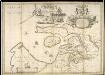
A new and exact map of the River Clyde done by the late Mr. John Adair / now publish'd for the good of the publick by Geo. Scott.
Adair, John, ca. 1650-1722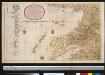
Nieuwe afteekening van de West kust van SchotLandt als mede een gedeelte van de Lewijs Eijlanden en Skie, Mulla, Tijrrif, Col int groot
Scotland Gerard van Keulen
Scotland / J. Ainslie, 4
1 Blatt : 67 x 58 cm Ainslie, Faden
Belfast
1 : 250000 Belfast (Severní Irsko) War Office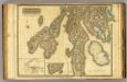
Argyllshire N.
1 : 175000 Thomson, John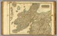
Argyllshire N.
1 : 175000 Thomson, John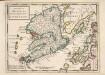
The Isle of Mull &c. Part of Argyle Shire / by H. Moll.
Moll, Herman, d. 1732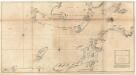
The west coast of Scotland from Ila to Mull.
Mackenzie, Murdoch (Senior), 1712-1797
Mvla insvla
1 Karte : Kupferdruck ; 41 x 53 cm Blaeu; Pont Joan Blaeu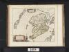
Mula Insula, quae ex Aebudarum numero una est, et Lochabriae ad occasum praetenditur. The Yle of Mul whiche is one of the Westerne Yles, and lyeth ovir against Lochabyr / Auct. Timoth. Pont.
Pont, Timothy, 1560?-1614? Blaeu, Joan, 1596-1673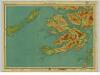
Mull & Iona, Sheet 10 - Bartholomew's "Half Inch to the Mile Maps" of Scotland
1 : 126720 Topographic maps John Bartholomew & Son, Ltd John Bartholomew & Son, Ltd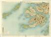
Mull, Sheet 10 - Bartholomew's "Half Inch to the Mile Maps" of Scotland
1 : 126720 Topographic maps Bartholomew, John George John Bartholomew & Co