Maps of Argyll and Bute

Composite: Argyllshire.
1 : 175000 Thomson, John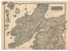
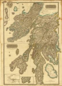
Northern Part of Argyll Shire.
Thomson, John, 1777- ca. 1840 Johnson, William, fl. 1806-1840
Southern Part of Argyll Shire.
Thomson, John, 1777- ca. 1840 Johnson, William, fl. 1806-1840
A map of such part of his Grace the Duke of Argyle's heritable dukedom, and justiciary territories, islands, superiorities & jurisdictions as lye contiguous upon the western Coast of North Britain
Cowley, J. (John)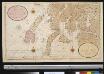
Nieuwe afteekening van de West kust van SchotLand als ook de eijlanden van Jura, Collensa, IJla, Cantijra en Arren
Great-Britain Gerard van Keulen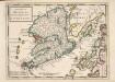
The Isle of Mull &c. Part of Argyle Shire / by H. Moll.
Moll, Herman, d. 1732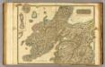
Argyllshire N.
1 : 175000 Thomson, John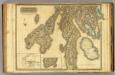
Argyllshire N.
1 : 175000 Thomson, John
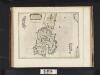
Mvla insvla
1 Karte : Kupferdruck ; 41 x 53 cm Blaeu; Pont Joan Blaeu
Mula Insula, quae ex Aebudarum numero una est, et Lochabriae ad occasum praetenditur. The Yle of Mul whiche is one of the Westerne Yles, and lyeth ovir against Lochabyr / Auct. Timoth. Pont.
Pont, Timothy, 1560?-1614? Blaeu, Joan, 1596-1673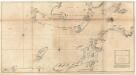
The west coast of Scotland from Ila to Mull.
Mackenzie, Murdoch (Senior), 1712-1797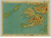
Mull & Iona, Sheet 10 - Bartholomew's "Half Inch to the Mile Maps" of Scotland
1 : 126720 Topographic maps John Bartholomew & Son, Ltd John Bartholomew & Son, Ltd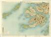
Mull, Sheet 10 - Bartholomew's "Half Inch to the Mile Maps" of Scotland
1 : 126720 Topographic maps Bartholomew, John George John Bartholomew & Co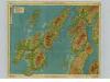
Islay & Jura, Sheet 6 - Bartholomew's "Half Inch to the Mile Maps" of Scotland
1 : 126720 Topographic maps John Bartholomew & Son, Ltd John Bartholomew & Son, Ltd
Islay, Jura, Colonsay, Sheet 6 - Bartholomew's "Half Inch to the Mile Maps" of Scotland
1 : 126720 Topographic maps Bartholomew, John George John Bartholomew & Co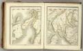
Sheets 73-74. (Cary's England, Wales, and Scotland).
1 : 360000 Cary, John, ca. 1754-1835
Islay, Jura, Colonsay &c.
Great Britain. Hydrographic Office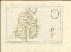

IVRA INSVLA | The Yle of IVRA | one of the westerne Iles | of SCOTLAND.
Auct. Timoth. Pont. [Amsterdam : Joan Blaeu]
MVLA INSVLA, | quæ ex Æbudarum numero una est, | et Lochabriæ ad occasum prætenditur. | THE YLE OF MVL | whiche is one of the westerne Yles, | and lyeth ovir [!] against Lochabyr
Auct. Timoth. Pont. [Amsterdam : Joan Blaeu]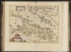
Lorna cum insulis vicinis et provinciis eidem conterminis. Lorn wt the Yles and provinces bordering there-upon / Auct. Timoth. Pont.
Pont, Timothy, 1560?-1614? Blaeu, Joan, 1596-1673
Lorna cum insulis vicinis et provinciis eidem conterminis
1 Karte : Kupferdruck ; 38 x 51 cm Blaeu; Pont Joan Blaeu
Ila insvla
1 Karte : Kupferdruck ; 53 x 51 cm Blaeu; Pont Joan Blaeu
Iura Insula, The Yle of Iura one of the westerne Iles of Scotland / Auct. Timoth. Pont.
Pont, Timothy, 1560?-1614? Blaeu, Joan, 1596-1673
Ivra insvla
1 Karte : Kupferdruck ; 40 x 51 cm Blaeu; Pont Joan Blaeu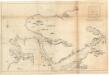
The sound of Mull.
Mackenzie, Murdoch (Senior), 1712-1797
LORNA cum insulis vicinis | et provinciis eidem conterminis. | LORN Wt the Yles and provinces | bordering there-vpon.
Auct. Timoth. Pont. [Amsterdam : Joan Blaeu]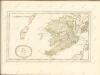

ILA INSVLA, | ex Æbudarum majoribus una. | THE YLE OF ILA, | being one of the biggest of the Westerne Yles.
Auct. Tim. Pont. [Amsterdam : Joan Blaeu]