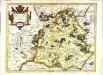
Maps of Landkreis Kassel
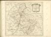
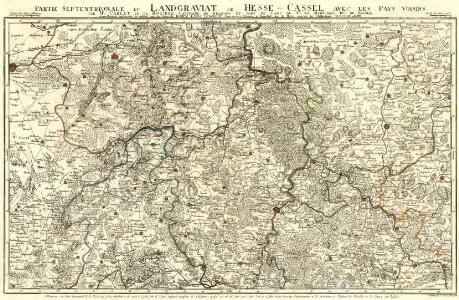
Partie Septentrionale du Landgraviat de Hesse-Cassel avec les Pays Voisins
1 : 130000 Mollova mapová sbírka Carlet, Louis-François Back, Jakob Conrad Broenner, Heinrich Ludwig II.
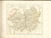
Eveché de Paderborn
1 : 230000 Mollova mapová sbírka Le Rouge, Georges-Louis Baisiez Le Rouge, Georges-Louis
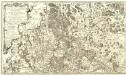
Recens et Accurata Designatio Episcopatus Paderbornensis in suas Dioecenses et Praefect. Exacte Distincti
1 : 230000 Mollova mapová sbírka Seutter, Matthäus Seutter, Matthäus
Carte de l'Evêché de Paderborn
1 : 180000 Mollova mapová sbírka Carlet, Louis-François Lotter, Tobias Conrad
Landgrafiatvs Hasso-Cassellanvs typo geographico quatuor Foliorum expressus Cura Homannianorum Heredum Norimb: 1761
1 : 160000 Mollova mapová sbírka Homann, Johann Baptist Homann, Johann Baptista - dědici
Le Landgraviat de Hesse-Cassel Meridional et Septentr: avec une Partie du Landgraviat de Hesse-Darmstat et de la Vetteravie avec autres dependences
1 : 200000 Mollova mapová sbírka Carlet, Louis-François Lotter, Tobias Conrad
Le Landgraviat de Hesse-Cassel Meridional et Septentr: avec une Partie du Landgraviat de Hesse-Darmstat et de la Vetteravie avec autres dependences
1 : 200000 Mollova mapová sbírka Carlet, Louis-François Lotter, Tobias Conrad
Landgraviatus Hassiae Inferioris Comitatvs Waldeciae Eichsfeldiae Tabvla Geographica
1 : 140000 Mollova mapová sbírka Berger, Daniel
Waldeccensis Comitatus Descriptio Accuratissima. [Karte], in: Theatrum orbis terrarum, S. 145.
1 Karte aus Atlas Ortelius, Abraham

Waldeck comitatus
1 Karte : Kupferdruck ; 34 x 44 cm Hondius; Mercator Henricus Hondius
Waldeck comitatus
1 Karte : Kupferdruck ; 34 x 44 cm Mercator s.n.
Waldeck Comitatus. [Karte], in: Le théâtre du monde, ou, Nouvel atlas contenant les chartes et descriptions de tous les païs de la terre, Bd. 1, S. 175.
1 Karte aus Atlas Blaeu, Willem Janszoon und Blaeu, Joan Blaeu, Willem Janszoon
WALDECK | COMITATVS
Amsterdami | Apud Guiljelmum Blaeu
Waldeck Comitatus. [Karte], in: Gerardi Mercatoris Atlas, sive, Cosmographicae meditationes de fabrica mundi et fabricati figura, S. 355.
1 Karte aus Atlas Mercator, Gerhard Montanus, Petrus
Waldeck Comitatus. [Karte], in: Novus atlas absolutissimus, Bd. 2, S. 165.
1 Karte aus Atlas Janssonius Offizin
Waldeck Comitatus. [Karte], in: Novus Atlas, das ist, Weltbeschreibung, Bd. 1, S. 144.
1 Karte aus Atlas Blaeu, Joan Blaeu, Willem Janszoon
Waldeck Comitatus. [Karte], in: Theatrum orbis terrarum, sive, Atlas novus, Bd. 1, S. 236.
1 Karte aus Atlas Blaeu, Joan Blaeu, Willem Janszoon
Waldeck Comitatus. [Karte], in: Gerardi Mercatoris et I. Hondii Newer Atlas, oder, Grosses Weltbuch, Bd. 1, S. 215.
1 Karte aus Atlas Mercator, Gerhard und Hondius, Jodocus Jansson, Jan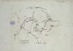
Verproviantirung von Göttingen im Januar 1761
Carte Demi-Topo-Graphique De La Partie Septentrionale du Landgraviat de Hesse-Cassel
1 : 190000 Mollova mapová sbírka Carlet, Louis-François Beaurain, Jean de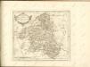

Ducatus Westphaliae Cum annexis
1 : 270000 Mollova mapová sbírka Gigas, Johann Michael Gigas, Johannes
Ducatus Westphaliae Cum annexis
1 : 270000 Mollova mapová sbírka Gigas, Johann Michael Gigas, Johannes
Waldeccensis comitatvs descriptio accvratissima
1 Karte : Kupferdruck ; 31 x 21 cm Moers; Ortelius s.n.
Waldecciae ac Finitimorum Dominiorum Itterani & Casteiniani nec non infertae Dioeceses Eimelrodensis accurata Tabula excusa
1 : 110000 Mollova mapová sbírka Homann, Johann Baptist Homann, Johann Baptista - dědici
111. Arolsen, uit: Topographische Uebersichtskarte des Deutschen Reiches / herausgegeben v. d. Kartogr. Abt. d. Königl. Preuß. Landesaufnahme
1 : 200000 titelvariant: Topogr. Übersichtskarte des Deutschen Reiches; Annotatie: Titel boven bladen ook: Topogr. Übersichtskarte des Deutschen Reiches; Annotatie geografische gegevens: Op elk blad twee maatstokken: 10 Kilometer = 5,5 cm; 1 geogr. Meile = 3,6 cm; Legenda onder op elk blad Königlich Preußische Landesaufnahme. Kartographische Abtheilung [S.l : Königlich Preußische Landesaufnahme, Kartographische Abtheilung]