Maps of Landkreis Kassel

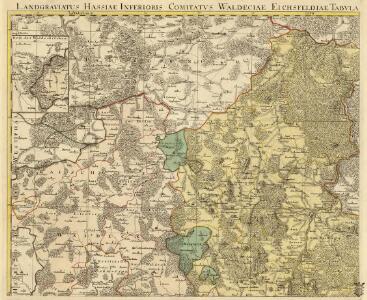
Landgraviatus Hassiae Inferioris Comitatvs Waldeciae Eichsfeldiae Tabvla Geographica
1 : 140000 Mollova mapová sbírka Berger, Daniel
Landgrafiatvs Hasso-Cassellanvs typo geographico quatuor Foliorum expressus Cura Homannianorum Heredum Norimb: 1761
1 : 160000 Mollova mapová sbírka Homann, Johann Baptist Homann, Johann Baptista - dědici

Plan de la Bataille de Wilhelmsthal
1 : 55000 Mollova mapová sbírka Bauer, Friedrich Wilhelm von Schley, Jacobus van der Gosse, Pierre II.
Sect. Warburg
1 : 80000 titelvariant: Warburg; Annotatie geografische gegevens: Legenda rechts van de kaart [Berlin : Simon Schropp'sche Hof-Landkartenhandlung]
Tableau Topographique Qui comprend la Partie Septentrionale du Landgraviat de Hesse Cassel et de la Principauté de Waldeck, l'Eveché de Paderborn, Partie du Comté de Grubenhague et les Frontieres de ces Etats]
1 : 130000 Mollova mapová sbírka Julien, Roch-Joseph Julien, Roch Joseph
Waldecciae ac Finitimorum Dominiorum Itterani & Casteiniani nec non infertae Dioeceses Eimelrodensis accurata Tabula excusa
1 : 110000 Mollova mapová sbírka Homann, Johann Baptist Homann, Johann Baptista - dědici
Plan du Siege de Cassel, avec les Travaux et les Tranchées des Alliés devant cette Place
1 : 20000 Mollova mapová sbírka Gerlach, H. D. Schley, Jacobus van der Gosse, Pierre II.
Plan du siege de Cassel, avec les travaux et les tranchées des alliés devant cette place, commande par S. A. S. Monseigneur Le Prince Frederic Auguste Duc de Brunswic et de Luneburg, ... depuis le 18. d'Aout jusqu'au 1. Novembre 1762 où la place se [...]
1 : 22000 ... levé par H.D. Gerlach lieutenant du Genie gravé sous la direction de J. v. Schley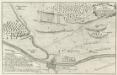
Plan der Action welche zwischen denen Französischen und Hessischen Trouppen d: 23 Jul: 1758 ohnweit Cassel bey Hof- Ellenbach vorgefallen
Mollova mapová sbírka
Uebersicht der nicht geschlossenen Gewässer des Regierungsbezirks Cassel und deren Schonzeiten
Kassel (Německo) Wenderoth, Georg
Meßtischblatt 2732 : Waldeck, 1914
1 : 250000 Waldeck. - Aufn. 1906, hrsg. 1908, Aufl.-dr. 1914. - 1:25000. - [Berlin]: Reichsamt für Landesaufnahme, 1914. - 1 Kt.
Meßtischblatt 2731 : Korbach, 1936
1 : 250000 Korbach. - Hrsg. 1908, einz. Nachtr. 1924, gedr. [19]36. - 1:25000. - [Berlin]: Reichsamt für Landesaufnahme, 1936. - 1 Kt.
Meßtischblatt 2665 : Kassel (Ost), 1927
1 : 250000 Kassel (Ost). - Hrsg. 1909, einz. Nachtr. 1927. - 1:25000. - [Berlin]: Reichsamt für Landesaufnahme, 1927. - 1 Kt.
Meßtischblatt 2665 : Cassel (Ost), 1909
1 : 250000 Cassel (Ost). - Aufn. 1907. - 1:25000. - [Berlin]: Reichsamt für Landesaufnahme, 1909. - 1 Kt.
Meßtischblatt 2664 : Cassel (West), 1909
1 : 250000 Cassel (West). - Aufn. 1907. - 1:25000. - [Berlin]: Reichsamt für Landesaufnahme, 1909. - 1 Kt.
Meßtischblatt 2663 : Wolfhagen, 1908
1 : 250000 Wolfhagen. - Aufn. 1906. - 1:25000. - [Berlin]: Reichsamt für Landesaufnahme, 1908. - 1 Kt.
Meßtischblatt 2662 : Arolsen, 1933
1 : 250000 Arolsen. - Aufn. 1906, einz. Nachtr. 1926. - 1:25000. - [Berlin]: Reichsamt für Landesaufnahme, [19]33. - 1 Kt.
Meßtischblatt 2662 : Arolsen, 1908
1 : 250000 Arolsen. - Aufn. 1906. - 1:25000. - [Berlin]: Reichsamt für Landesaufnahme, 1908. - 1 Kt.
Meßtischblatt 2661 : Mengeringhausen, 1932
1 : 250000 Mengeringhausen. - Hrsg. 1908, einz. Nachtr. 1926. - 1:25000. - [Berlin]: Reichsamt für Landesaufnahme, [19]32. - 1 Kt.
Meßtischblatt 2661 : Mengeringhausen, 1908
1 : 250000 Mengeringhausen. - Aufn. 1906. - 1:25000. - [Berlin]: Reichsamt für Landesaufnahme, 1908. - 1 Kt.
Messtischblatt 2591 : Hann. Münden, 1926 Hann. Münden
1 : 250000 Hann. Münden. - Aufn. 1907, einz. Nachtr. 1926. - 1:25000. - [Berlin]: Reichsamt für Landesaufnahme, 1926. - 1 Kt.
Messtischblatt 2588 : Warburg, 1933 Warburg
1 : 250000 Warburg. - Hrsg. 1909, einz. Nachtr. 1932, [gedr. 19]33. - 1:25000. - [Berlin]: Reichsamt für Landesaufnahme, 1933. - 1 Kt.
Messtischblatt 2587 : Marsberg, 1909 Marsberg
1 : 250000 Marsberg. - Aufn. 1907. - 1:25000. - [Berlin]: Reichsamt für Landesaufnahme, 1909. - 1 Kt.
Meßtischblatt 2518 : Ödelsheim, 1926
1 : 250000 Ödelsheim. - Aufn. 1896, einz. Nachtr. 1926. - 1:25000. - [Berlin]: Reichsamt für Landesaufnahme, 1926. - 1 Kt.
Meßtischblatt 2518 : Ödelsheim, 1898
1 : 250000 Ödelsheim. - Aufn. 1896. - 1:25000. - [Berlin]: Reichsamt für Landesaufnahme, 1898. - 1 Kt.
Meßtischblatt 2517 : Trendelburg, 1898
1 : 250000 Trendelburg. - Aufn. 1896. - 1:25000. - [Berlin]: Reichsamt für Landesaufnahme, 1898. - 1 Kt.
Meßtischblatt 2516 : Borgentreich, 1932
1 : 250000 Borgentreich. - Hrsg. 1898, bericht. 1907, einz. Nachtr. 1932. - 1:25000. - [Berlin]: Reichsamt für Landesaufnahme, 1932. - 1 Kt.
Meßtischblatt 2516 : Borgentreich, 1907
1 : 250000 Borgentreich. - Aufn. 1896, hrsg. 1898, bericht. 1907. - 1:25000. - [Berlin]: Reichsamt für Landesaufnahme, 1907. - 1 Kt.