Maps of Landkreis Göttingen
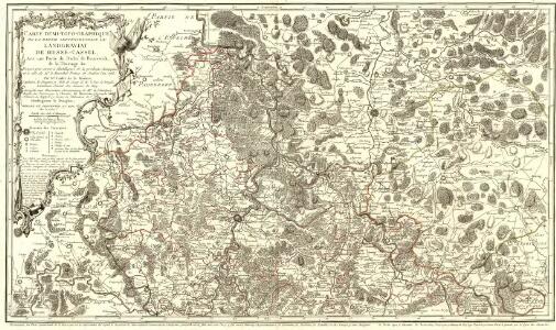
Carte Demi-Topo-Graphique De La Partie Septentrionale du Landgraviat de Hesse-Cassel
1 : 190000 Mollova mapová sbírka Carlet, Louis-François Beaurain, Jean de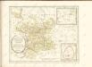

Cassel 72, uit: [W. Liebenow's Special-Karte von Mittel-Europa]
1 : 300000 titelvariant: W. Liebenow's Mittel-Europa; Annotatie: Titel boven de bladen: W. Liebenow's Mittel-Europa Johannes Wilhelm Liebenow 1822-1897 Hannover : Hermann Oppermann
Cassel-Göttingen 72, uit: Special-Karte von Mittel-Europa / nach amtlichen Quellen bearbeitet von W. Liebenow
1 : 300000 titelvariant: W. Liebenow's Mittel-Europa; Annotatie: Titel boven de bladen: W. Liebenow's Mittel-Europa Johannes Wilhelm Liebenow 1822-1897 Frankfurt a. M. : Ludwig Ravenstein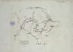
Verproviantirung von Göttingen im Januar 1761

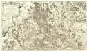
Le Landgraviat de Hesse-Cassel Meridional et Septentr: avec une Partie du Landgraviat de Hesse-Darmstat et de la Vetteravie avec autres dependences
1 : 200000 Mollova mapová sbírka Carlet, Louis-François Lotter, Tobias Conrad
99. Göttingen, uit: Topographische Uebersichtskarte des Deutschen Reiches / herausgegeben v. d. Kartogr. Abt. d. Königl. Preuß. Landesaufnahme
1 : 200000 titelvariant: Topogr. Übersichtskarte des Deutschen Reiches; Annotatie: Titel boven bladen ook: Topogr. Übersichtskarte des Deutschen Reiches; Annotatie geografische gegevens: Op elk blad twee maatstokken: 10 Kilometer = 5,5 cm; 1 geogr. Meile = 3,6 cm; Legenda onder op elk blad Königlich Preußische Landesaufnahme. Kartographische Abtheilung [S.l : Königlich Preußische Landesaufnahme, Kartographische Abtheilung]
Landt Tafel des Eyßfeldts
1 : 180000 Mollova mapová sbírka Fluck, Johann Merian, Matthäus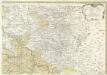
Landgrafiatvs Hasso-Cassellanvs typo geographico quatuor Foliorum expressus Cura Homannianorum Heredum Norimb: 1761
1 : 160000 Mollova mapová sbírka Homann, Johann Baptist Homann, Johann Baptista - dědici
Tractvs Eichsfeldiae in suas Praefecturas divisae nec non Territorii Mvlhvsani Chorographia
1 : 160000 Mollova mapová sbírka Homann, Johann Baptist Homann, Johann Baptista - dědici
Landgraviatus Hassiae Inferioris Comitatvs Waldeciae Eichsfeldiae Tabvla Geographica
1 : 140000 Mollova mapová sbírka Berger, Daniel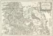
Tableau Topographique Qui comprend la Partie Septentrionale du Landgraviat de Hesse Cassel et de la Principauté de Waldeck, l'Eveché de Paderborn, Partie du Comté de Grubenhague et les Frontieres de ces Etats
1 : 130000 Mollova mapová sbírka Julien, Roch-Joseph Julien, Roch Joseph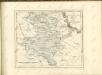

Composite: 335. Einbeck.
1 : 100000 Reichsamt fur Landesaufnahme
335. Einbeck.
1 : 100000 Reichsamt fur Landesaufnahme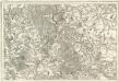
Tableau Topographique Qui comprend la Partie Septentrionale du Landgraviat de Hesse Cassel et de la Principauté de Waldeck, l'Eveché de Paderborn, Partie du Comté de Grubenhague et les Frontieres de ces Etats]
1 : 130000 Mollova mapová sbírka Julien, Roch-Joseph Julien, Roch Joseph
75. Friedland a. d. Alle. (Germany)
1 : 100000 Reichsamt fur Landesaufnahme
Composite: 75. Friedland a. d. Alle. (Germany)
1 : 100000 Reichsamt fur Landesaufnahme
334. Hoxter.
1 : 100000 Reichsamt fur Landesaufnahme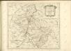

Les Environs de Cassel en Hesse et le Plan de la Battaille entre Sandershausen et Lutternberg le 10. Octobre 1758
Mollova mapová sbírka Back, Jakob Conrad
Composite: 334. Hoxter.
1 : 100000 Reichsamt fur Landesaufnahme
Uebersicht der nicht geschlossenen Gewässer des Regierungsbezirks Cassel und deren Schonzeiten
Kassel (Německo) Wenderoth, Georg
Meßtischblatt 4727 : Küllstedt, 1937
1 : 250000 Küllstedt. - Hrsg. 1909, einz. Nachtr. 1936. - 1:25000. - [Berlin]: Reichsamt für Landesaufnahme, 1937. - 1 Kt.
Meßtischblatt 2738 : Grebendorf, 1936
1 : 250000 Grebendorf. - Hrsg. 1909, einz. Nachtr. 1936. - 1:25000. - [Berlin]: Reichsamt für Landesaufnahme, 1936. - 1 Kt.
Meßtischblatt 2737, neue Nr. 4725 : Bad Sooden- Allendorf, 1936
1 : 250000 Bad Sooden - Allendorf. - Hrsg. 1909, einz. Nachtr. 1936. - 1:25000. - [Berlin]: Reichsamt für Landesaufnahme, 1936. - 1 Kt.
Meßtischblatt 2737 : Allendorf- Sooden, 1913
1 : 250000 Allendorf- Sooden. - [Hrsg. 1909, gedr. 19]13. - 1:25000. - [Berlin]: Reichsamt für Landesaufnahme, 1913. - 1 Kt.
Meßtischblatt 2736 : Großalmerode, 1936
1 : 250000 Großalmerode. - Hrsg. 1909, einz. Nachtr. 1936. - 1:25000. - [Berlin]: Reichsamt für Landesaufnahme, 1936. - 1 Kt.
Meßtischblatt 2669, neue Nr. 4627 : Dingelstädt, 1937
1 : 250000 Dingelstädt. - Hrsg. 1908, einz. Nachtr. 1937. - 1:25000. - [Berlin]: Reichsamt für Landesaufnahme, 1937. - 1 Kt.