Maps of Landkreis Emsland

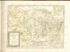
L'Eveché de Munster Le Comté de Bentheim Tecklenbourg Stenford Lingen, Diepholtz Delmenhorst, Ritberg &c.
1 : 420000 Mollova mapová sbírka Le Rouge, Georges-Louis Le Rouge, Georges-Louis
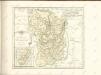
Basse Partie de l'Evesché de Munster, et le Comté de Benthem
1 : 300000 Mollova mapová sbírka Sanson, Guillaume Mortier, Pierre
Basse Partie De L'Evesché De Munster, Et Le Comté De Benthem. [Karte], in: Atlas nouveau, contenant toutes les parties du monde [...], Bd. 1, S. 307.
1 Karte aus Atlas Sanson, Nicolas Jaillot, Alexis Hubert und Mortier, Pieter
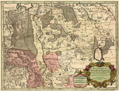
Carte Nouvelle de l'Eveché de Munster
1 : 180000 Mollova mapová sbírka Grancourt
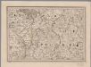
Territorium Seculare Episcopatvs Monasterii Mvnster Germanis dicti
1 : 420000 Mollova mapová sbírka Homann, Johann Baptist Homann, Johann Baptista - dědici
Monasteriensis et Osnabvrgensis episcopatvs descriptio
1 Karte : Kupferdruck ; 36 x 25 cm Mascop; Ortelius s.n.
Monasteriensis et Osnabvrgensis episcopatvs descriptio
1 Karte : Kupferdruck ; 25 x 36 cm Mascop; Ortelius s.n.
Carta del vescovato di Mvnster
1 : 480000 Münster in Westfalen-oblast (Německo) Bouttats, Gerhaert Hacque, Johann Baptist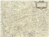
Carta del vescovato di Mvnster
1 : 480000 Münster in Westfalen-oblast (Německo) Bouttats, Gerhaert Hacque, Johann Baptist
Monasteriensis episcopatvs
1 : 485000 Münster in Westfalen-oblast (Německo) Janssonius, Johannes apud Ioannem Ianßonium
Monasteriensis episcopatus
1 : 485000 Münster in Westfalen-oblast (Německo) Gigas, Johann Michael Blaeu, Willem Janszoon apud Guiljelmum Blaeuw
MONASTERIENSIS | Episcopatus
Judocus Hondius excudit.
Monasteriensis Episcopatvs
1 : 470000 Mollova mapová sbírka Schenk, Pieter Schenk, Peter I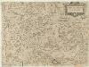
Carta del Vescovato di Mvnster
1 : 450000 Mollova mapová sbírka Hacque, Johann Baptist
Monasteriensis Episcopatus
1 : 460000 Mollova mapová sbírka Hondius, Jodocus Hondius, Jodocus
Monasteriensis Episcopatvs
1 : 460000 Mollova mapová sbírka Gigas, Johann Michael Blaeu, Joan I.
Monasteriensis Episcopatus
1 : 460000 Mollova mapová sbírka Gigas, Johann Michael Blaeu, Willem Jansz.
1:250 000 Europe
1 : 250000 Osnabrück (Německo) War Office
Episcopatvs Monasteriensis Pars Septentrionalis
1 : 290000 Mollova mapová sbírka Gigas, Johann Michael
Episcopatvs Monasteriensis Pars Septentrionalis
1 : 290000 Mollova mapová sbírka Gigas, Johann Michael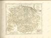

Carte topographique d'Allemagne
1 : 214500 Friesland (Německo) Jaeger, Johann Wilhelm Abraham I.W.A. Iaeger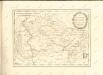

Le Theatre de Bellone :
Mollova mapová sbírka Schenk, Pieter Braakman, Adriaan
[8], uit: Hydro-Oro und Chorographische General Karte des Koenigreichs der Niederlande und der angrenzenden Länder bis Paris : mit der Angabe der Kunst und Heer-Strassen und der Entfernung der Poststationen / ... zusammengetragen und reducirt von ... Wilhelm Müller
1 : 400000 titelvariant: Generalkarte des Koenigreichs Hannover; Annotatie: 1e supplement bij: Generalkarte des Koenigreichs Hannover (1818) Müller, Wilhelm (fl. 1818) [Hannover : Wilhelm Müller]
Bremen 44, uit: [W. Liebenow's Special-Karte von Mittel-Europa]
1 : 300000 titelvariant: W. Liebenow's Mittel-Europa; Annotatie: Titel boven de bladen: W. Liebenow's Mittel-Europa Johannes Wilhelm Liebenow 1822-1897 Hannover : Hermann Oppermann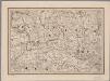
[12], uit: Hydro-Oro und Chorographische General Karte des Koenigreichs der Niederlande und der angrenzenden Länder bis Paris : mit der Angabe der Kunst und Heer-Strassen und der Entfernung der Poststationen / ... zusammengetragen und reducirt von ... Wilhelm Müller
1 : 400000 titelvariant: Generalkarte des Koenigreichs Hannover; Annotatie: 1e supplement bij: Generalkarte des Koenigreichs Hannover (1818) Müller, Wilhelm (fl. 1818) [Hannover : Wilhelm Müller]