Maps of Landkreis Cloppenburg


Bremen 44, uit: [W. Liebenow's Special-Karte von Mittel-Europa]
1 : 300000 titelvariant: W. Liebenow's Mittel-Europa; Annotatie: Titel boven de bladen: W. Liebenow's Mittel-Europa Johannes Wilhelm Liebenow 1822-1897 Hannover : Hermann Oppermann
Bremen 44, uit: Special-Karte von Mittel-Europa / nach amtlichen Quellen bearbeitet von W. Liebenow
1 : 300000 titelvariant: W. Liebenow's Mittel-Europa; Annotatie: Titel boven de bladen: W. Liebenow's Mittel-Europa Johannes Wilhelm Liebenow 1822-1897 Frankfurt a. M. : Ludwig Ravenstein
Nobilis Saxoniae Fl. Visvrgis cum Terris adjacentib. Ab Inclyta Brema ad Ostium Maris
1 : 130000 Mollova mapová sbírka Merian, Matthaeus Merian, Matthäus - dědici
Composite: 206. Bremen. (Germany)
1 : 100000 Reichsamt fur Landesaufnahme
Central Europe 1:1,000,000, Bremen
Sheet M3 of the 287 sheet series: Central Europe. 1 : 100,000. G.S.G.S. No. 4416. AMS. M641, M651, M671. [London?] ; Washington, D.C. : War Office : Army Map Service, U.S. Army.
205. Oldenburg. (Germany)
1 : 100000 Reichsamt fur Landesaufnahme
206. Bremen. (Germany)
1 : 100000 Reichsamt fur Landesaufnahme
Composite: 205. Oldenburg. (Germany)
1 : 100000 Reichsamt fur Landesaufnahme
204. Leer. (Germany)
1 : 100000 Reichsamt fur Landesaufnahme
Composite: 204. Leer. (Germany)
1 : 100000 Reichsamt fur Landesaufnahme
13 Bourtange, uit: Topographische en militaire kaart van het Koningrijk der Nederlanden / vervaardigd door de officieren van den Generale Staf ; en gegraveerd op het Topographisch Bureau, van het Ministerie van Oorlog
1 : 50000 titelvariant: TMK; Annotatie: Met bladwijzer op schaal 1:600.000. - 1915; Met Verklaring van de topographische en militaire kaart van het Koninkrijk der Nederlanden. - 1910; Bd. 1: titelblad, bladwijzer, verklaring, bladen 1 t/m 32; Bd. 2: bladen 33 t/m 62 Generale Staf, Nederland; Ministerie van Oorlog. Topographisch Bureau ['s-Gravenhage : Ministerie van Oorlog]
232. Sogel.
1 : 100000 Reichsamt fur Landesaufnahme
Afteekening van de rivier de Weeser, van de stad Brema tot 't eijland Hamelwerdersand in 't groodt
Germany Gerard van Keulen
233. Cloppenburg.
1 : 100000 Reichsamt fur Landesaufnahme
Composite: 233. Cloppenburg.
1 : 100000 Reichsamt fur Landesaufnahme
Composite: 232. Sogel.
1 : 100000 Reichsamt fur Landesaufnahme
234. Wildeshausen.
1 : 100000 Reichsamt fur Landesaufnahme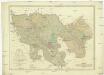
Karte des Gebiethes der Reichs und Hanse Stadt Bremen
1 : 39400 Brémy (Německo) Heineken, Christian Abraham Tischbein, Georg Heinrich
Composite: 234. Wildeshausen.
1 : 100000 Reichsamt fur Landesaufnahme
Kaart van Westerwolde : zijnde het 6e schooldistrict in de Provincie Groningen
1 : 120000 [S.l. : s.n.]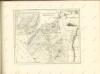

Prospect und Grundris der Keisrl. Freyen REichs und Ansee Stadt Bremen samt ihrer Gegend
1 : 30000 Mollova mapová sbírka Homann, Johann Baptist Homann, Johann Baptista
Composite: 203. Bunde. (Germany)
1 : 100000 Reichsamt fur Landesaufnahme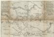
Eigendliche anweisung wie deß heiligen Reichss Statt Bremen in diesen 1666 Jahre von 30 Augusti biß den 15 Novemb.
1 : 50000 Mollova mapová sbírka Schultz, C.
231. Haren.
1 : 100000 Reichsamt fur Landesaufnahme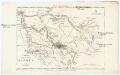
Charte der freien Stadt Bremen nebst Gebiet
1 : 85000 Brémy (Německo : oblast) Schlieben Gleditsch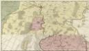
Comitatus Oldenburgensis]
Mollova mapová sbírka Loon, Jan van Schenk, Peter I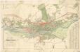
Plan von Bremen