Maps of Landkreis Osnabrück

Osnabrvgensis Episcopatvs
1 : 470000 Mollova mapová sbírka Gigas, Johann Michael Schenk, Peter I
Osnabrvgensis Episcopatvs
1 : 470000 Mollova mapová sbírka Gigas, Johann Michael
Osnabrugensis episcopatus / auctore Ioanne Gigante ; [Willem Jansz. Blaeu]
1 : 250000 Annotatie: Bij deze 2e staat zijn de lengtegraden in de kaartrand veranderd van O 28°40'-30°20' in O 25°20'-26°50'; Origineel is Blad 77 in atlas factice; Oorspr. uitg.: Atlantis appendix, sive pars altera ... - Amsterdami : apud Guiljelmum Blaeuw, 1630 Gigas, Joannes (1580-1650); Blaeu, Willem Jansz. Amstelodami : Guiljelm. Blaeu excudit [i.e. Joan Blaeu]
OSNABRVGENSIS | EPISCOPATVS
Auctore Ioanne Gigante. Amstelodami, | Guiljelm. Blaeuw | Excudit
Eveché D'Osnabruc
1 : 170000 Mollova mapová sbírka Le Rouge, Georges-Louis Baisiez Le Rouge, Georges-Louis
Territorii Episcopatvs Osnabrvgensis Tabulae geographica
1 : 160000 Mollova mapová sbírka Gigas, Johann Michael Homann, Johann Baptista - dědici
Teritorii episcopatvs Osnabrvgensis tabula geographica
1 : 161000 Osnabrück (Německo) Gigas, Johann Michael Mayer, Tobias impensis Homanniorum heredum
84. Osnabrück, uit: Topographische Uebersichtskarte des Deutschen Reiches / herausgegeben v. d. Kartogr. Abt. d. Königl. Preuß. Landesaufnahme
1 : 200000 titelvariant: Topogr. Übersichtskarte des Deutschen Reiches; Annotatie: Titel boven bladen ook: Topogr. Übersichtskarte des Deutschen Reiches; Annotatie geografische gegevens: Op elk blad twee maatstokken: 10 Kilometer = 5,5 cm; 1 geogr. Meile = 3,6 cm; Legenda onder op elk blad Königlich Preußische Landesaufnahme. Kartographische Abtheilung [S.l : Königlich Preußische Landesaufnahme, Kartographische Abtheilung]
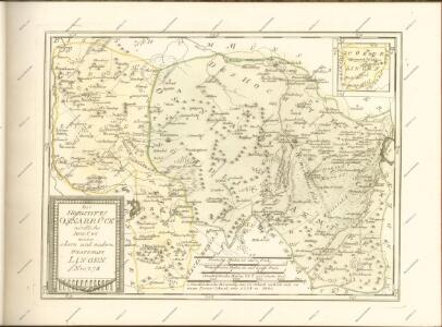
Delineatio episcopatus Osnabrugensis
Osnabrück (Německo) Reinhold, Christian Ludolph Benoit, Franz Christian de Tob. Conr. Lotter

Composite: 283. Osnabruck.
1 : 100000 Reichsamt fur Landesaufnahme
283. Osnabruck.
1 : 100000 Reichsamt fur Landesaufnahme
Composite: 257. Haselunne.
1 : 100000 Reichsamt fur Landesaufnahme
282. Rheine.
1 : 100000 Reichsamt fur Landesaufnahme
Composite: 282. Rheine.
1 : 100000 Reichsamt fur Landesaufnahme
258. Vechta.
1 : 100000 Reichsamt fur Landesaufnahme
Composite: 258. Vechta.
1 : 100000 Reichsamt fur Landesaufnahme
257. Haselunne.
1 : 100000 Reichsamt fur Landesaufnahme
Germany 1:25,000, Hunteburg
Germany 1:25,000 , Series GSGS 4414. Great Britain. War Office. [London] : War Office
Germany 1:25,000, Vorden
Germany 1:25,000 , Series GSGS 4414. Great Britain. War Office. [London] : War Office
Germany 1:25,000, Salzbergen
Germany 1:25,000 , Series GSGS 4414. Great Britain. War Office. [London] : War Office
Germany 1:25,000, Damme
Germany 1:25,000 , Series GSGS 4414. Great Britain. War Office. [London] : War Office
Germany 1:25,000, Mettingen
Germany 1:25,000 , Series GSGS 4414. Great Britain. War Office. [London] : War Office
Germany 1:25,000, Bevergen
Germany 1:25,000 , Series GSGS 4414. Great Britain. War Office. [London] : War Office
Germany 1:25,000, Hopsten
Germany 1:25,000 , Series GSGS 4414. Great Britain. War Office. [London] : War Office
Germany 1:25,000, Bramsche
Germany 1:25,000 , Series GSGS 4414. Great Britain. War Office. [London] : War Office
Meßtischblatt 2012 : Schledehausen, 1933
1 : 250000 Schledehausen. - Hrsg. 1897, einz. Nachtr. 1926, gedr. [19]33. - 1:25000. - [Berlin]: Reichsamt für Landesaufnahme, 1933. - 1 Kt.
Meßtischblatt 2010 : Hasbergen, 1929
1 : 250000 Hasbergen. - Hrsg. 1897, bericht. 1929. - 1:25000. - [Berlin]: Reichsamt für Landesaufnahme, 1929. - 1 Kt.