Maps of Landkreis Trier-Saarburg

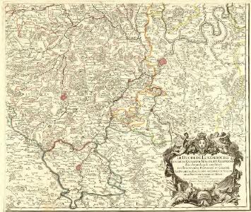
Le Duché de Luxembourg divisé en Quartier Walon, et Allemand
1 : 140000 Mollova mapová sbírka Jaillot, Alexis-Hubert Jaillot, Alexis Hubert
Le Duché de Luxembourg divisé en Quartier Walon et Allemand
1 : 140000 Mollova mapová sbírka Jaillot, Alexis-Hubert Jaillot, Alexis Hubert
Karten einiger an dem Ufer deß Rhein ligender Festungen worbey die Kaiserl. Byhler Hagenauer und Weissenburger Linien, wie auch die Battaille bey Hünninge und iezte Glorieuse Belagerung Landau angezeigt. alles mit sonderbahrem Fleiss gezeichentg
Německo Fuchs, Johann Conrad Jeremia Wolff
Estats entre la Nied la Sare et le Rhin ou sont la Lorraine allemande le duché de Deux Ponts, les comtés de Bitsche, de Spanheim et de Linange, partie du palatinat meridional l'entrée en Alsace et en Lorraine par les villes de Sarlouis de Hombourg de Landau et leurs environs
1 : 200000 Lotrinsko (Francie) Sengre, Henri Jaillot, Alexis-Hubert Iaillot
Charte des Baierschen [sic] Rheinkreises
1 : 629000 Bavorsko (Německo) Martin Gleditsch
[25], uit: Hydro-Oro und Chorographische General Karte des Koenigreichs der Niederlande und der angrenzenden Länder bis Paris : mit der Angabe der Kunst und Heer-Strassen und der Entfernung der Poststationen / ... zusammengetragen und reducirt von ... Wilhelm Müller
1 : 400000 titelvariant: Generalkarte des Koenigreichs Hannover; Annotatie: 1e supplement bij: Generalkarte des Koenigreichs Hannover (1818) Müller, Wilhelm (fl. 1818) [Hannover : Wilhelm Müller]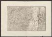
Militair Karte von Süd-Deutschland in 20 Sectionen
1 : 400000 5. Section Coulon, Alois von A. von Coulon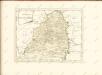

Die Pfalz oder Rhein - Bayern
Electorat et Palatinat du Rhein
1 : 190000 Mollova mapová sbírka Fer, Nicolas de Inselin, Charles Danet, Guillaume
Partie Occidentale Du Palatinat et Eslectorat Du Rhein Le Duché De Simmeren, Les Comtés De Spanheim, et De Veldentz a la Maison Palatine. [...] [Karte], in: Atlas nouveau, contenant toutes les parties du monde [...], Bd. 1, S. 180.
1 Karte aus Atlas Sanson, Nicolas Jaillot, Alexis Hubert und Mortier, Pieter
Trier 112, uit: Special-Karte von Mittel-Europa / nach amtlichen Quellen bearbeitet von W. Liebenow
1 : 300000 titelvariant: W. Liebenow's Mittel-Europa; Annotatie: Titel boven de bladen: W. Liebenow's Mittel-Europa Johannes Wilhelm Liebenow 1822-1897 Frankfurt a. M. : Ludwig Ravenstein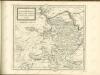

Trier 112, uit: [W. Liebenow's Special-Karte von Mittel-Europa]
1 : 300000 titelvariant: W. Liebenow's Mittel-Europa; Annotatie: Titel boven de bladen: W. Liebenow's Mittel-Europa Johannes Wilhelm Liebenow 1822-1897 Hannover : Hermann Oppermann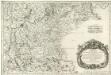
Treveri Archidiacones de Treves, et de Tholey dans le Dioecese de l'Archevesché de Treves.
Mollova mapová sbírka Sanson, Guillaume Sanson, Guillaume
Carte topographique d'Allemagne
1 : 224000 Falc Rýnská Jaeger, Johann Wilhelm Abraham I. W. A. Iaeger
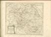
Partie Orientale du Palatinat et Eslectorat du Rhein.
1 : 260000 Mollova mapová sbírka Sanson, Guillaume Jaillot, Alexis Hubert
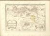
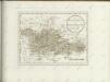
Le Duché de Luxembourg
1 : 316000 Mollova mapová sbírka Sanson, Guillaume Jaillot, Alexis Hubert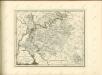

Mannheim 113, uit: [W. Liebenow's Special-Karte von Mittel-Europa]
1 : 300000 titelvariant: W. Liebenow's Mittel-Europa; Annotatie: Titel boven de bladen: W. Liebenow's Mittel-Europa Johannes Wilhelm Liebenow 1822-1897 Hannover : Hermann Oppermann
Mannheim 113, uit: Special-Karte von Mittel-Europa / nach amtlichen Quellen bearbeitet von W. Liebenow
1 : 300000 titelvariant: W. Liebenow's Mittel-Europa; Annotatie: Titel boven de bladen: W. Liebenow's Mittel-Europa Johannes Wilhelm Liebenow 1822-1897 Frankfurt a. M. : Ludwig Ravenstein
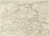
Partie Occidentale du Palatinat et Eslectorat du Rhein
1 : 125000 Mollova mapová sbírka Sanson, Guillaume Jaillot, Alexis Hubert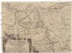
Eigentliche Entwerffung deßn Marquis Spinolae Lägern bey Maintz und Oppenheim
Mohuč (Německo)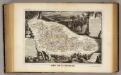
Dept. De La Moselle.
1 : 455000 Levasseur, Victor.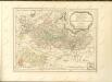

Section Worms, uit: Charte von dem Grossherzogtum Hessen und dem Herzogtum Nassau / trigonometrisch aufgenommen und hrsg. von C.L.P. Eckhardt
1 : 200000 titelvariant: Karte von Hessen und Nassau Eckhardt, C. L. P Darmstadt : Joh. Wilh. Heyer