Maps of Carpathian Mountains
Danubius Fluminum Europaerum Princeps
1 : 3200000 Mollova mapová sbírka Haupt, Gottfried Jacob Haupt, Gottfried Jacob
Galizien, Ungarn, Slavonien, Kroatien, Siebenburgen, Dalmatien, Moldau, Wallachey.
1 : 10000000 Brudin, J. L.; Stieler, Adolf
Galizien, Ungarn mit Slavonien und Croatien, Siebenbürgen und Dalmatien, Moldau, Wallachey
1 : 3700000 Chorvatsko Justus Perthes
Obščaja karta Vengrii i Transil'vanii
1 : 2700000 Maďarsko Beketov, V.
[Galizien, Ungarn Slavonien und Croatien, Siebenbürgen und Dalmatien, Moldau, Wallachey]
Hand-Atlas über alle Theile der Erde nach dem neuesten Zustande und über das Weltgebäude Stieler, Adolf bei Justus Perthes

Galizien, Ungarn mit Sclavonien und Croatien, Siebenbürgen und Dalmatien; Moldau, Walachey]
Stieler's Hand-Atlas Stieler, Adolf bei Justus Perthes
Die Karpathen im Alterthum
Karpaten Altertum
Heerstrasse von Constantinopel nach Nissa
Balkánský poloostrov
Etats orientaux de l'empereur a partir de la Baviere et de la Boheme
1 : 3170000 Evropa jihovýchodní Mentelle, Edme Tardieu, Pierre François
Ungarn und seine Nebenlande bis zum Aussterben Arpadischen Stammers 1301.
1 : 3800000 Spruner von Merz, Karl
Pohraničí Rakousko-Uherska, Rumunska, Srbska a Bulharska
1 : 1250000 Bulharsko Machát, František V. Neubert
Die Laender an der untern Donau Vten.-Xte. Jahrhundert.
1 : 3800000 Spruner von Merz, Karl
General Charte von Ungarn
1 : 2390000 Bukovina (Rumunsko a Ukrajina) Güssefeld, Franz L. Rausch, Johann Lorenz Jakob bey den Homannischen Erben
Karpatenländer, politische Übersicht
1 : 6000000 Donau-Karpaten-Gebiet
Karpatenländer, Flusz- & Gebirgskarte
1 : 6000000 Donau-Karpaten-Gebiet
Ungarn und seine sudlichen Nachbarlander seit 1526.
1 : 3800000 Spruner von Merz, Karl
Le Royaume de Hongrie
1 : 1300000 Mollova mapová sbírka Sanson, Guillaume Covens, Johannes I

Etats Orientaux De L'Empereur a partir De La Baviere Et De La Boheme : pour l'Ouvrage intitulé: De la Monarchie Prussienne
Mentelle, Edme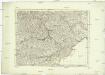
La Moldavie, la Valakie, et la Transilvanie, avec partie de la Bulgarie, de la Hongrie, et de la Pologne
Bulharsko Santini, P. P. Santini
Ungarn und seine Nebenlande nach ihrer kirchlichen Eintheilung bis in das XVte. Jahrhundert.
1 : 3800000 Spruner von Merz, Karl
Beschreibung aller laender so etwan dem künigreich Poland underworffen seind gewesen, oder sunst mi
1 : 7500000 1 Karte : Holzschnitt ; 10 x 14 cm Münster, Sebastian [Henricpetri]
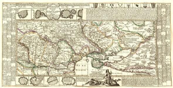
Nova et Accurata Regni Hungariae Tabula, ad Usum Serenissimi Burgundiae Ducis
1 : 2900000 Mollova mapová sbírka Jaillot, Alexis-Hubert Ottens, Josua
Nova et Accurata Tabula Regnorum Sup. et Inf. Hungariae
1 : 2500000 Mollova mapová sbírka Bodenehr, Gabriel Bodenehr, Gabriel
Russia in Europe / the map drawn & engraved by J. Rapkin ; the illustrations by A.H. Wray & engraved
1 : 15206400 1 Karte : Lithographie ; 29 x 22 cm Wray, A.H. J. & F. Tallis
Austro-Hungarian Monarchy (eastern sheet).
1 : 1642000 Johnston, Alexander Keith
Russia in Europe / drawn & engraved by J. Dower ...
1 : 15000000 1 Karte : Lithogr. (mehrfarb.) ; 25 x 20 cm Dower, John Orr & Smith
Mappa Królestwa Polskiego / ułożona na zasadzie źródeł urzędowych prez M. Nipanicza
1 : 735000 1 Karte : Lithografie, koloriert ; 126 x 99 cm Nipanicz, Mikołaj [Verlag nicht ermittelbar]