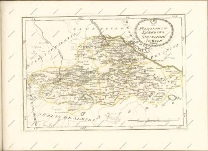
Maps of Lüchow-Dannenberg

Carte topographique d'Allemagne
1 : 214500 Braniborsko (Německo) Jaeger, Johann Wilhelm Abraham Berndt, Johann Christoph I.W.A. Iaeger
Wittenberge 46, uit: Special-Karte von Mittel-Europa / nach amtlichen Quellen bearbeitet von W. Liebenow
1 : 300000 titelvariant: W. Liebenow's Mittel-Europa; Annotatie: Titel boven de bladen: W. Liebenow's Mittel-Europa Johannes Wilhelm Liebenow 1822-1897 Frankfurt a. M. : Ludwig Ravenstein

74. Salzwedel, uit: Topographische Uebersichtskarte des Deutschen Reiches / herausgegeben v. d. Kartogr. Abt. d. Königl. Preuß. Landesaufnahme
1 : 200000 titelvariant: Topogr. Übersichtskarte des Deutschen Reiches; Annotatie: Titel boven bladen ook: Topogr. Übersichtskarte des Deutschen Reiches; Annotatie geografische gegevens: Op elk blad twee maatstokken: 10 Kilometer = 5,5 cm; 1 geogr. Meile = 3,6 cm; Legenda onder op elk blad Königlich Preußische Landesaufnahme. Kartographische Abtheilung [S.l : Königlich Preußische Landesaufnahme, Kartographische Abtheilung]
Composite: 210. Lunenburg. (Germany)
1 : 100000 Reichsamt fur Landesaufnahme
Composite: 211. Dannenberg. (Germany)
1 : 100000 Reichsamt fur Landesaufnahme
Composite: 212. Lenzen. (Germany)
1 : 100000 Reichsamt fur Landesaufnahme
212. Lenzen. (Germany)
1 : 100000 Reichsamt fur Landesaufnahme
263. Wittingen.
1 : 100000 Reichsamt fur Landesaufnahme
211. Dannenberg. (Germany)
1 : 100000 Reichsamt fur Landesaufnahme
239. Salzwedel.
1 : 100000 Reichsamt fur Landesaufnahme
209. Amelinghausen. (Germany)
1 : 100000 Reichsamt fur Landesaufnahme
240. Seehausen.
1 : 100000 Reichsamt fur Landesaufnahme
210. Lunenburg. (Germany)
1 : 100000 Reichsamt fur Landesaufnahme
Composite: 239. Salzwedel.
1 : 100000 Reichsamt fur Landesaufnahme
Composite: 237. Soltau.
1 : 100000 Reichsamt fur Landesaufnahme
58. Lauenburg a.d. Elbe, uit: Topographische Uebersichtskarte des Deutschen Reiches / herausgegeben v. d. Kartogr. Abt. d. Königl. Preuß. Landesaufnahme
1 : 200000 titelvariant: Topogr. Übersichtskarte des Deutschen Reiches; Annotatie: Titel boven bladen ook: Topogr. Übersichtskarte des Deutschen Reiches; Annotatie geografische gegevens: Op elk blad twee maatstokken: 10 Kilometer = 5,5 cm; 1 geogr. Meile = 3,6 cm; Legenda onder op elk blad Königlich Preußische Landesaufnahme. Kartographische Abtheilung [S.l : Königlich Preußische Landesaufnahme, Kartographische Abtheilung]
Composite: 240. Seehausen.
1 : 100000 Reichsamt fur Landesaufnahme
Composite: 209. Amelinghausen. (Germany)
1 : 100000 Reichsamt fur Landesaufnahme
237. Soltau.
1 : 100000 Reichsamt fur Landesaufnahme
Composite: 265. Gardelegen.
1 : 100000 Reichsamt fur Landesaufnahme
265. Gardelegen.
1 : 100000 Reichsamt fur Landesaufnahme
Germany 1:25,000, Garlstorf
Germany 1:25,000 , Series GSGS 4414. Great Britain. War Office. [London] : War Office
Germany 1:25,000, Luneberg
Germany 1:25,000 , Series GSGS 4414. Great Britain. War Office. [London] : War Office
Germany 1:25,000, Kirchgellersen
Germany 1:25,000 , Series GSGS 4414. Great Britain. War Office. [London] : War Office
Meßtischblatt 3337 : Stendal, 1938
1 : 250000 Stendal. - Hrsg. 1882, einz. Nachtr. 1938. - 1:25000. - [Berlin]: Reichsamt für Landesaufnahme, 1938. - 1 Kt.
Meßtischblatt 1756 : Stendal, 1882
1 : 250000 Stendal. - Aufn. 1880. - 1:25000. - [Berlin]: Kgl. Preuss. Landesaufnahme, 1882. - 1 Kt.
Meßtischblatt 3336 : Schinne, 1938
1 : 250000 Schinne. - Hrsg. 1902, einz. Nachtr. 1938. - 1:25000. - [Berlin]: Reichsamt für Landesaufnahme, 1938. - 1 Kt.