Maps of Uelzen

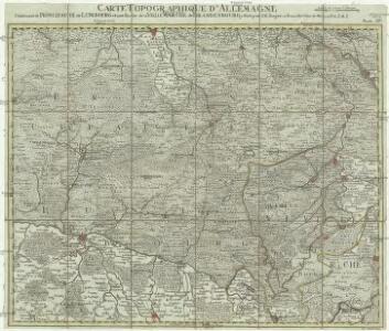
Carte topographique d'Allemagne
1 : 214500 Braniborsko (Německo) Jaeger, Johann Wilhelm Abraham Berndt, Johann Christoph I.W.A. Iaeger

74. Salzwedel, uit: Topographische Uebersichtskarte des Deutschen Reiches / herausgegeben v. d. Kartogr. Abt. d. Königl. Preuß. Landesaufnahme
1 : 200000 titelvariant: Topogr. Übersichtskarte des Deutschen Reiches; Annotatie: Titel boven bladen ook: Topogr. Übersichtskarte des Deutschen Reiches; Annotatie geografische gegevens: Op elk blad twee maatstokken: 10 Kilometer = 5,5 cm; 1 geogr. Meile = 3,6 cm; Legenda onder op elk blad Königlich Preußische Landesaufnahme. Kartographische Abtheilung [S.l : Königlich Preußische Landesaufnahme, Kartographische Abtheilung]
263. Wittingen.
1 : 100000 Reichsamt fur Landesaufnahme
Composite: 211. Dannenberg. (Germany)
1 : 100000 Reichsamt fur Landesaufnahme
Composite: 210. Lunenburg. (Germany)
1 : 100000 Reichsamt fur Landesaufnahme
264. Klotze.
1 : 100000 Reichsamt fur Landesaufnahme
Composite: 237. Soltau.
1 : 100000 Reichsamt fur Landesaufnahme
211. Dannenberg. (Germany)
1 : 100000 Reichsamt fur Landesaufnahme
239. Salzwedel.
1 : 100000 Reichsamt fur Landesaufnahme
Composite: 262. Celle.
1 : 100000 Reichsamt fur Landesaufnahme
209. Amelinghausen. (Germany)
1 : 100000 Reichsamt fur Landesaufnahme
Composite: 263. Wittingen.
1 : 100000 Reichsamt fur Landesaufnahme
Composite: 239. Salzwedel.
1 : 100000 Reichsamt fur Landesaufnahme
262. Celle.
1 : 100000 Reichsamt fur Landesaufnahme
210. Lunenburg. (Germany)
1 : 100000 Reichsamt fur Landesaufnahme
237. Soltau.
1 : 100000 Reichsamt fur Landesaufnahme
Composite: 209. Amelinghausen. (Germany)
1 : 100000 Reichsamt fur Landesaufnahme
Meßtischblatt 99 : Jeggau, 1873
1 : 250000 Jeggau. - Aufgen. 1858. - 1:25000. - [Berlin]: Reichsamt für Landesaufnahme, 1873. - 1 Kt.
Meßtischblatt 1823 : Kunrau, 1938
1 : 250000 Kunrau. - Hrsg. 1902, einz. Nachtr. 1932, redakt. Änd. 1938, Ausgabe F. - 1:25000. - [Berlin]: Reichsamt für Landesaufnahme, 1938. - 1 Kt.
Meßtischblatt 1823 : Kunrau, 1913
1 : 250000 Kunrau. - Aufn. 1900, hrsg. 1902, Auflagedr. 1913. - 1:25000. - [Berlin]: Reichsamt für Landesaufnahme, 1913. - 1 Kt.
Meßtischblatt 3431 : Steimke, 1937
1 : 250000 Steimke. - Hrsg. 1902, letzte Nachtr. 1932, gedr. [19]37. - 1:25000. - [Berlin]: Reichsamt für Landesaufnahme, 1937. - 1 Kt.
Meßtischblatt 3430 : Ehra, 1938
1 : 250000 Ehra. - Hrsg. 1901, kl. Nachtr. 1924, gedr. [19]38. - 1:25000. - [Berlin]: Reichsamt für Landesaufnahme, 1938. - 1 Kt.
Meßtischblatt 1821 : Ehra, 1901
1 : 250000 Ehra. - Aufn. 1899. - 1:25000. - [Berlin]: Reichsamt für Landesaufnahme, 1901. - 1 Kt.
Meßtischblatt 1820 : Gamsen, 1901
1 : 250000 Gamsen. - Aufn. 1899. - 1:25000. - [Berlin]: Reichsamt für Landesaufnahme, 1901. - 1 Kt.
Meßtischblatt 3428 : Müden, 1937
1 : 250000 Müden. - Hrsg. 1901, einz. Nachtr. 1932, gedr. [19]37. - 1:25000. - [Berlin]: Reichsamt für Landesaufnahme, 1937. - 1 Kt.
Meßtischblatt 1819 : Müden, 1901
1 : 250000 Müden. - Aufn. 1899. - 1:25000. - [Berlin]: Reichsamt für Landesaufnahme, 1901. - 1 Kt.
Meßtischblatt 1818 : Bröckel, 1937
1 : 250000 Bröckel. - Hrsg. 1901, einz. Nachtr. 1931, gedr. [19]37. - 1:25000. - [Berlin]: Reichsamt für Landesaufnahme, 1937. - 1 Kt.
Meßtischblatt 1817 : Wathlingen, 1901
1 : 250000 Wathlingen. - Aufn. 1899, hrsg. 1901. - 1:25000. - [Berlin]: Reichsamt für Landesaufnahme, 1901. - 1 Kt.