Maps of Lüchow-Dannenberg

Composite: 211. Dannenberg. (Germany)
1 : 100000 Reichsamt fur Landesaufnahme
211. Dannenberg. (Germany)
1 : 100000 Reichsamt fur Landesaufnahme
Meßtischblatt 2933 : Gr. Gusborn, 1940
1 : 250000 Gr. Gusborn. - Hrsg. 1881. - 1:25000. - [Berlin]: Reichsamt für Landesaufnahme, 1940. - 1 Kt.
Meßtischblatt 2932 : Breese, 1937
1 : 250000 Breese. - Hrsg. 1881, einz. Nachtr. 1924. - 1:25000. - [Berlin]: Reichsamt für Landesaufnahme, 1937. - 1 Kt.
Meßtischblatt 2931 : Gülden, 1939
1 : 250000 Gülden. - Hrsg. 1881, einz. Nachtr. 1939. - 1:25000. - [Berlin]: Reichsamt für Landesaufnahme, 1939. - 1 Kt.
Meßtischblatt 2833 : Dömitz, 1953
1 : 250000 Dömitz. - Hrsg. 1881, letzte Nachtr. 1939. - 1:25000. - [S.l.]: MdI, 1953. - 1 Kt.
Meßtischblatt 1385 : Dannenberg, 1939
1 : 250000 Dannenberg. - Hrsg. 1881, einz. Nachtr. 1939. - 1:25000. - [Berlin]: Reichsamt für Landesaufnahme, 1939. - 1 Kt.
Meßtischblatt 1384, neue Nr. 2831 : Bredenbock, 1939
1 : 250000 Bredenbock. - Hrsg. 1891, einz. Nachtr. 1939. - 1:25000. - [Berlin]: Reichsamt für Landesaufnahme, 1939. - 1 Kt.
Meßtischblatt 3033 : Woltersdorf, Stand 1939, gedruckt 1965
1 : 250000 Woltersdorf. - Hrsg. 1881, einz. Nachtr. 1939, [gedr. 19]65. - 1:25000. - [Berlin]: Reichsamt für Landesaufnahme, [19]65. - 1 Kt.
Meßtischblatt 3032 : Lüchow, 1939
1 : 250000 Lüchow. - Hrsg. 1881, einz. Nachtr. 1939. - 1:25000. - [Berlin]: Reichsamt für Landesaufnahme, 1939. - 1 Kt.
Meßtischblatt 1537 : Clenze, 1881
1 : 250000 Klenze. - Aufn. 1879, hrsg. 1881. - 1:25000. - [Berlin]: Reichsamt für Landesaufnahme, 1881. - 1 Kt.
Meßtischblatt 1463 : Himbergen, 1924
1 : 250000 Himbergen. - Aufn. 1899, Nachtr. 1924. - 1:25000. - [Berlin]: Reichsamt für Landesaufnahme, 1924. - 1 Kt.
Meßtischblatt 1383 : Dahlenburg, 1901
1 : 250000 Dahlenburg. - Aufn. 1899. - 1:25000. - [Berlin]: Reichsamt für Landesaufnahme, 1901. - 1 Kt.
Meßtischblatt 1536 : Suhlendorf, 1932
1 : 250000 Suhlendorf. - Hrsg. 1901, einz. Nachtr. 1932. - 1:25000. - [Berlin]: Reichsamt für Landesaufnahme, 1932. - 1 Kt.
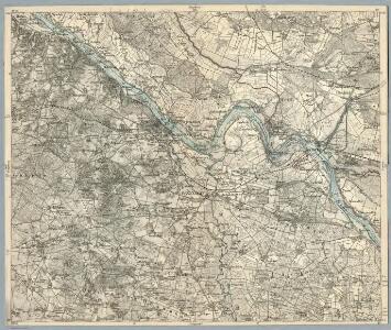
58. Lauenburg a.d. Elbe, uit: Topographische Uebersichtskarte des Deutschen Reiches / herausgegeben v. d. Kartogr. Abt. d. Königl. Preuß. Landesaufnahme
1 : 200000 titelvariant: Topogr. Übersichtskarte des Deutschen Reiches; Annotatie: Titel boven bladen ook: Topogr. Übersichtskarte des Deutschen Reiches; Annotatie geografische gegevens: Op elk blad twee maatstokken: 10 Kilometer = 5,5 cm; 1 geogr. Meile = 3,6 cm; Legenda onder op elk blad Königlich Preußische Landesaufnahme. Kartographische Abtheilung [S.l : Königlich Preußische Landesaufnahme, Kartographische Abtheilung]
Composite: 210. Lunenburg. (Germany)
1 : 100000 Reichsamt fur Landesaufnahme
239. Salzwedel.
1 : 100000 Reichsamt fur Landesaufnahme
Composite: 239. Salzwedel.
1 : 100000 Reichsamt fur Landesaufnahme
Meßtischblatt 1303 : Neuhaus a. d. Elbe, 1938
1 : 250000 Neuhaus a. d. Elbe. - Hrsg. 1881, bericht. 1906, einz. Nachtr. 1919, redakt. Änd. 1938. - 1:25000. - [Berlin]: Reichsamt für Landesaufnahme, 1938. - 1 Kt.
Meßtischblatt 1303 : Neuhaus a. d. Elbe, 1913
1 : 250000 Neuhaus a. d. Elbe. - Aufn. 1879, hrsg. 1881, Auflagedr. 1913. - 1:25000. - [Berlin]: Reichsamt für Landesaufnahme, 1913. - 1 Kt.
Meßtischblatt 2732 : Jessenitz, 1953
1 : 250000 Jessenitz. - Hrsg. 1900, bericht. 1906, letzte Nachtr. 1939. - 1:25000. - [S.l.]: 1953. - 1 Kt.
Meßtischblatt 2733 : Leussow, 1939
1 : 250000 Leussow. - Hrsg. 1881, ber. 1906, einz. Nachtr. 1939. - 1:25000. - [Berlin]: Reichsamt für Landesaufnahme, 1939. - 1 Kt.
Meßtischblatt 1302 : Bleckede, 1901
1 : 250000 Bleckede. - Aufn. 1879/99. - 1:25000. - [Berlin]: Reichsamt für Landesaufnahme, 1901. - 1 Kt.
Carte topographique d'Allemagne
1 : 214500 Braniborsko (Německo) Jaeger, Johann Wilhelm Abraham Berndt, Johann Christoph I.W.A. Iaeger
Wittenberge 46, uit: Special-Karte von Mittel-Europa / nach amtlichen Quellen bearbeitet von W. Liebenow
1 : 300000 titelvariant: W. Liebenow's Mittel-Europa; Annotatie: Titel boven de bladen: W. Liebenow's Mittel-Europa Johannes Wilhelm Liebenow 1822-1897 Frankfurt a. M. : Ludwig Ravenstein
Mappa Ducatus Megalopolitani Nova :
1 : 190000 Mollova mapová sbírka


Ducatus Luneburgicus cum comitatu Dannebergensi
1 : 336000 Lüneburg (Německo) Seutter, Matthäus Matth. Seutter