Maps of Mérida

Mappa ou carta geographica dos reinos de Portugal e Algarve, 4
1 Blatt : 55 x 44 cm Dury
Estremadura con las nuevas divisiones
1 : 600000 formado por A. H. Dufour Paris : Bulla
Provincia Extremadura
1 Karte : Kupferdruck ; 44 x 47 cm López curaverunt Homann. Heredes
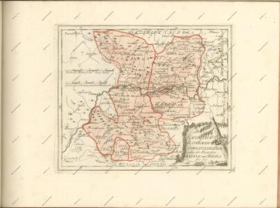
Mapa de la provincia de Estremadura
1 Karte auf 2 Blatt : Kupferdruck ; 37 x 72 cm López; Velazquez; Venegas s.n.
Mapa general del reyno de Portugal, 3
2 Blätter : 35 x 78 cm Tomás López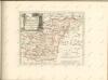

Mapa geografico de las sierras de Guadalupe
1 Karte : Kupferdruck ; 33 x 37 cm López s.n.

Parte meridional do reyno de Portugal
1 Karte : Kupferdruck ; 40 x 52 cm Sanson em casa del autor
Partie meridionale du royaume de Portugal
1 Karte : Kupferdruck ; 47 x 52 cm Bellin; Santini; Remondini chez M. Remondini
Andalvzia continens Sevillam et Cordvbam
1 Karte : Kupferdruck ; 36 x 48 cm Janssonius Joannes Janssonius
Andalvzia continens Sevillam et Cordvbam
1 Karte : Kupferdruck ; 36 x 48 cm Blaeu Joan Blaeu
Andaluzia
1 Karte : Kupferdruck ; 17 x 24 cm Mercator; Keere Cloppenburgh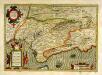
Andaluziæ nova descript
1 Karte : Kupferdruck ; 34 x 49 cm Mercator; Hondius; Hondius Henricus Hondius
Andaluziæ nova descript
1 Karte : Kupferdruck ; 34 x 49 cm Hondius; Mercator Jodocus Hondius
Regnum Portugalliae divisum in quinque provincias majores & subdivisum in sua quaeque territoria una cum Regno Algabriae speciali mappa exhibitum
1 : 1050000 Algarve (Portugalsko) Homann, Johann Baptist H., H. per Ioh. Bapt. Homannum
REGNUM PORTUGALLIAE Divisum In Quinque Provincias majores & Subdivisum in sua quaeque Territoria una cum REGNO ALGARBIAE speciali mappa exhibitum
1 : 1050000 Portugalsko Homann, Johann Baptist Nolin, Jean-Baptiste per H. H.
Regnum Portugalliae divisum in quinque provincias majores & subdivisum in sua quaeque territoria una cum Regno Algarbiae speciali mappa exhibitum
1 : 1050000 Algarve (Portugalsko) Homann, Johann Baptist Nolin, Jean-Baptiste per H. H.
Estremadura con las nuevas divisiones
1 Mapa. Atlas Nacional de España. Dufour, A.H. 0
Neueste Generalkarte von Portugal und Spanien
Portugalsko Votésky, Michael Benedicti, Hieronymus F.A. Schraembl
Andaluziae Nova Descript. [Karte], in: Gerardi Mercatoris et I. Hondii Newer Atlas, oder, Grosses Weltbuch, Bd. 2, S. 204.
1 Karte aus Atlas Mercator, Gerhard und Hondius, Jodocus Jansson, Jan
Regnorum Castellæ veteris Legionis et Gallæciæ principatuumque Biscaiæ et Asturiarum accuratissima descriptio, 4
1 Blatt : 54 x 41 cm Visscher
Portugalliae que olim Lusitania, novißima et exactißima descriptio [Karte], in: Gerardi Mercatoris Atlas, sive, Cosmographicae meditationes de fabrica mundi et fabricati figura, S. 177.
1 Karte aus Atlas Mercator, Gerhard Montanus, Petrus
Regna Portugalliae et Algarbiae, cum adjacentibus Hispaniae provinciis
1 : 1280000 Algarve (Portugalsko) Lotter, Georg F. Tob. Conr. Lotter
Royaume de Portugal
1 Karte : Kupferdruck ; 53 x 41 cm Duval; Michu chez l'autheur en l'isle du Palais sur le quay de l'Orloge proche le coin de la ruë de Harlay
A new and accurate map of Portugal
1 Karte : Kupferdruck ; 31 x 21 cm Bowen s.n.
Nova regni Portugalliæ et Algarbiæ descriptio
1 Karte auf 2 Blatt : Kupferdruck ; 73 x 54 cm Jaillot; Sanson chez H. Iaillot
Nova regni Portugalliæ et Algarbiæ descriptio
1 Karte auf 2 Blatt : Kupferdruck ; 73 x 54 cm Jaillot; Sanson chez H. Iaillot