Maps of Extremadura

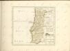
Mappa ou carta geographica dos reinos de Portugal e Algarve, 4
1 Blatt : 55 x 44 cm Dury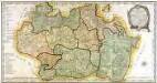
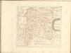
Mapa de la provincia de Estremadura
1 Karte auf 2 Blatt : Kupferdruck ; 37 x 72 cm López; Velazquez; Venegas s.n.
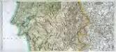
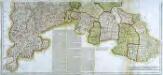
Estremadura con las nuevas divisiones
1 : 600000 formado por A. H. Dufour Paris : Bulla
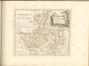
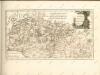
Provincia Extremadura
1 Karte : Kupferdruck ; 44 x 47 cm López curaverunt Homann. Heredes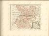
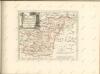

Mapa geografico de las sierras de Guadalupe
1 Karte : Kupferdruck ; 33 x 37 cm López s.n.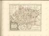


Partie meridionale du royaume de Portugal
1 Karte : Kupferdruck ; 47 x 52 cm Bellin; Santini; Remondini chez M. Remondini
L'Estremadura di Portogallo Alentejo, ed Algarve
1 Karte : Kupferdruck ; 31 x 32 cm Zatta Antonio Zatta
[Carte d'Espagne et de Portugal en neuf feuilles, 4]
1 Blatt : 31 x 41 cm P.G. Chanlaire
Espagne et Portugal, 4
1 Blatt : 31 x 42 cm Mentelle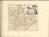
Mapa general del reyno de Portugal, 3
2 Blätter : 35 x 78 cm Tomás López
Li regni di Granata è d'Andalvcia / G. Cantelli da Vignola, 1
1 Blatt : Domenico de Rossi
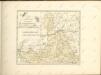
Mapa de la provincia de Alentejo
1 Karte : Kupferdruck ; 39 x 29 cm López s.n.
Mapa geografico de la provincia de Salamanca, 2
2 Blätter : 42 x 91 cm s.n.
Estremadura con las nuevas divisiones
1 Mapa. Atlas Nacional de España. Dufour, A.H. 0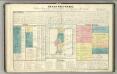
Tableau l'historie du Royaume de Portugal.
1 : 3900000 Duval, Henri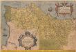
Portugalliae quae olim Lusitania novißima & exactißima descriptio [Karte], in: Theatrum orbis terrarum, S. 28.
1 Karte aus Atlas Ortelius, Abraham
Charte von Portugal
1 Karte : Kupferdruck ; 69 x 48 cm Faden im Verlage des Industrie Comptoirs
Carte de Portugal
1 : 950000 dressée par Pierre Tardieu Paris : Hocquart