Maps of Alentejo

Parte meridional do reyno de Portugal
1 Karte : Kupferdruck ; 40 x 52 cm Sanson em casa del autor
Carta de Portugal, aprovada para uso das escolas / Direccâo Geral dos Trabalhos Geodesicos e Topographicos
1 : 500000 Direcçâo Geral dos Trabalhos Geodesicos e Topographicos
Partie meridionale du royaume de Portugal
1 Karte : Kupferdruck ; 47 x 52 cm Bellin; Santini; Remondini chez M. Remondini
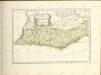
Partie méridionale du royaume de Portugal
1 Karte : Kupferdruck ; 47 x 51 cm Robert de Vaugondy G. et D. Robert de Vaugondy
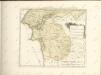
L'Estremadura di Portogallo Alentejo, ed Algarve
1 Karte : Kupferdruck ; 31 x 32 cm Zatta Antonio Zatta
Neueste Generalkarte von Portugal und Spanien
Portugalsko Votésky, Michael Benedicti, Hieronymus F.A. Schraembl
Provincias meridionales regni Portugalliae, scilicet Extremadura, Transtagana quibus regnum Algarbiae adiungitur
1 Mapa. Atlas von Spanien. Homannischen Erben ; Güssefeld, Franz Ludwig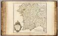
Portugal meridionale.
1 : 680000 Robert de Vaugondy, Gilles, 1688-1766
Provincias meridionales regni Portugalliæ, scilicet Extremadura, Transtagana, quibus regnum Algarbiæ adiungitur
1 Karte : Kupferdruck ; 54 x 44 cm Güssefeld; López Homann. haered
[Carte d'Espagne et de Portugal en neuf feuilles, 7]
1 Blatt : 31 x 41 cm P.G. Chanlaire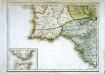
Espagne et Portugal, 7
1 Blatt : 31 x 42 cm Mentelle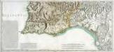
Mapa general del reyno de Portugal, 4
2 Blätter : 35 x 78 cm Tomás López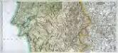
Mapa general del reyno de Portugal, 3
2 Blätter : 35 x 78 cm Tomás López

Mapa de la provincia de Alentejo
1 Karte : Kupferdruck ; 39 x 29 cm López s.n.

Mappa ou carta geographica dos reinos de Portugal e Algarve, 3
1 Blatt : 55 x 44 cm Dury
Hispalensis Conventus Delineatio [Karte], in: Theatrum orbis terrarum, S. 54.
1 Karte aus Atlas Ortelius, Abraham
Hispalensis Conventus Delineatio [Karte], in: Theatrum orbis terrarum, S. 101.
1 Karte aus Atlas Ortelius, Abraham Vrients, Jan Baptista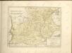

Mapa del reyno de Algarve
1 Karte : Kupferdruck ; 33 x 28 cm López s.n.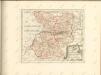


72. Madrid, Barselona (Barcelona), Lisbon, Strait of Gibraltar, Azores. The World Atlas.
1 : 250000 USSR (Union of Soviet Socialist Republics).
Quadro de juncçao das folhas que formam a carta dos arredores de Lisboa
1 : 20000
Mappa ou carta geographica dos reinos de Portugal e Algarve, 5
1 Blatt : 55 x 44 cm Dury


