Maps of Poland

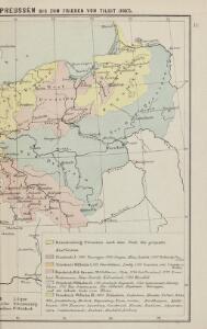
Geschichtl. Entwicklung des Königr. Preussen bis zum Frieden von Tilsit (1807)
Preußen, Polen, Tilsit / Friede
Polen unter Boleslaw Chrobry und bis 1139
1 : 12000000 Polen Bolesław I., Polen, König
Deutsch-österreich-russische Grenze
Polen Grenze
Poland, 1:2,000,000
1 : 2000000
Západní Rusko a přilehlé části říše Německé a Rakousko-Uherska
1 : 1250000 Německo východní Machát, František nákladem uměleckého ústavu grafického V. Neuberta
Nr. 18b. Hindenburgs Züge
Polen Weltkrieg <1914-1918>, Ostfront
Republika Polská

Polsko, Prusy, Poznáňsko [sic]
1 : 3890000 Polsko
Feuille 25 (D IV), uit: Carte géologique internationale de l'Europe : la carte, votée au congrès géologique international de Bologne en 1881, est exécutée conformément aux décisions d'une commission internationale, avec le concours des gouvernements, sous le dir. de M.M. Beyrich et Hauchecorne
Annotatie: Blad 48 gamme des couleurs; blad 49: bladwijzer en titelblad Heinrich Ernst Beyrich 1815-1896; Wi. Hauchecorne Berlin : Reimer / (Berlin: Institut lithographique)
Preussen und Polen
Schul-Atlas in 36 Karten Völter, Daniel Verlag der J.M. Dannheimer'schen Buchhandlung
Carte géologique de la République Polonaise
1 : 2500000 Kuźniar, Czesław; (Pologne) Service Géologique Lwów : Service Géologique de Pologne
Uebersichts Karte von Ost und West Preussen und Polen

Republika polská
1 : 1000000 Bělorusko
Polen und Preussen 1240 - 1386
1 : 6000000 Polen, Preußen (Ordensstaat)

Karte von den königl. preussischen Provinzen Preussen und Posen nebst dem kaiserlich russischen Königreiche Polen und dem Gebiete der freien Stadt Krakau
1 : 1370000 Gdaňsk (Polsko) Weiland, Karl Ferdinand Geogr. Institut
Karte von den königl. preussischen Provinzen Preussen und Posen nebst dem kaiserlich russischen Königreiche Polen und dem Gebiete der freien Stadt Krakau
1 : 1370000 Gdaňsk (Polsko) Weiland, Karl Ferdinand Mädel, J. im Verlage des geogr. Instituts
Karte von den Königl. Preussischen Provinzen Preussen und Posen nebst dem Kaiserlich Russischen Königreiche Polen und dem Gebiete der freien Stadt Krakau
1 : 1370000 Gdaňsk (Polsko) Weiland, Karl Ferdinand Mädel, J. Verlage des geogr. Instituts
Karte von den Königl. Preussischen Provinzen Preussen und Posen nebst dem Kaiserlich Russischen Königreiche Polen und dem Gebiete der freien Stadt Krakau
1 : 1370000 Gdaňsk (Polsko) Weiland, Karl Ferdinand Mädel, J. Verlage des geogr. Instituts
Zachodnie granice Polski
Polen Deutschland Deutsches Reich Grenze Wierzbicki, B.
Das Königreich Polen nebst den Königl. Preussischen Provinzen Preussen und Posen nebst dem Gebiete der freien Stadt Krakau
Preußen, Kongresspolen
Karte vom Königreiche Polen
1 : 3900000 Polsko Hamernik, Josef Lithographische Anstalt v. Zwettler & Nikl
Polen u. Nachbarländer 963 bis 992
1 : 12000000 Polen
Polen und Preussen 1140 - 1240
1 : 6000000 Polen, Preußen (Ordensstaat)
Weichsel
Weichsel (Fluss), Flusslauf
Preussen, Posen, Polen.
1 : 1370000 Weiland, C. F. (Carl Ferdinand), d. 1847
Superficie de petites exploitations privées (au-dessous de 50 ha) en proportions pour cent de la superficie générale
1 : 5000000 Polsko w Biurze kartograficznem
Mapa gęstości zaludnienia Polski
1 : 3000000 Polsko Lencewicz, Stanisław Uniwersytet Warszawski
Charte von dem Königreiche Polen, den königl. preussischen Provinzen Ost und West- Preussen und Posen nebst dem Gebiete der freien Stadt Krakau
1 : 1180000 Krakov (Polsko) Weiland, Karl Ferdinand im Verlage des Geograph. Instituts